Wednesday, November 28, 2007

Google Maps Street View Hits Knoxville, Pictures of Chevy Cobalt

google_street_view_car_002

Before the Thanksgiving weekend I was running around Knoxville, TN, doing some shopping when I ran into the familiar Google Chevy Cobalt. The Cobalt fleet was commissioned by Google to run around the country and map out parts of the U.S. for the popular Google Maps Street View.

The Google Maps Street View car looks like it was fixed up by one of our Shadetree mechanics here in the South. A wooden mount sits in the passenger seat that hold the monitor for the driver. The cameras are mounted on a metal rig on the roof held down by straps. The wires run through the window and into the back seat of the car, which is folded down, and then into the trunk where the data is stored.

google_street_view_car_008 The straps on top hold the camera rig down. You can make out the monitor in the passenger seat. google_street_view_car_007 The straps hold down the rigging with the GPS unit mounted on the rear of the structure. google_street_view_car_006 The cables from the roof run into the back seat which is folded down and into the trunk. google_street_view_car_004 The rear GPS system on the "high-tech" mounting rig. google_street_view_car_003 Another view of the cables running into the trunk. google_street_view_car_001 The Dell Monitor strapped to a cut fence post. Seriously, it's strapped to a 4x4 chunk of wood. google_street_view_car_005 The Google Maps Street View Chevy Cobalt from rear.

Google Earth Heading Towards Extinction?

Google has announced two new features for Google Maps that mimic features in Google Earth, begging the question: is Google Earth on borrowed time?

The first new feature is the additional of terrain in Google Maps. The terrain fly over feature has long been available in Google Earth, but now you can fly over a map and see the contours of the land, all without the need to download Google Earth.

The second new feature mimics the community contribution feature of Google Earth. "Our Maps" brings wiki-style collaboration to Google Maps, with users able to annotate places and share those notes with friends or the greater public.

Friday, November 23, 2007

Beijing's Environmental Challenge

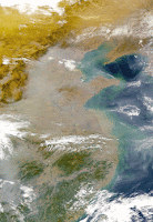
china beijing gisWith the 2008 Olympics coming up in Beijing, there's a lot of talk about air quality and traffic in the capital of China. One thousand new cars go on the road in Beijing every day, joining the three to four million cars that are already jamming the streets and threatening public health. Breath the air in Beijing and you're breathing the world's highest levels of lung-damaging nitrous oxide, according to a recent study. As well las a lot of particulates.

So China is facing a big challenge: how to move people without choking them.

Wednesday, November 21, 2007

Giant Sea Scorpion Fossil Found

sea scorpion fossilA giant fossilized claw discovered in Germany belonged to an ancient sea scorpion that was much bigger than the average man, an international team of geologists and archaeologists reported Tuesday.

The 46-centimetre-long claw was discovered by report co-author Markus Poschmann, from Germany, in a quarry near Pruem, a city about 200 kilometres east of Frankfurt.

The researchers said the scorpion lived between 460 and 255 million years ago and would have been among the top predators in its environment, feeding on early vertebrates and smaller arthropods. The report said the creature likely only lived in the water because with the construction of its body, "it is hardly imaginable how such a huge arthropod could effectively walk on land."

Black Friday Sale - Magellan Maestro 4000 GPS

GPS fans looking for a new toy for the holidays can hopefully grab the Magellan Maestro 4000 which is expected to drop $100 on Black Friday sales, the after Thanksgiving sale. Also reported to have huge price drops will be the Mio C220 and the Magellan Maestro 3100.

Friday, November 16, 2007

Tropical Cyclone Sidr in Google Earth, Hits Bangladesh Hard

Tropical Cyclone Sidr slammed into the Ganges Delta with winds of 250 kilometers (155 miles) per hour, causing devastation in Bangladesh before weakening over northern India.

At least 1,100 people in Bangladesh were killed from Tropical Cyclone Sidr, the Associated Press said today, citing the United News of Bangladesh. At least 1,000 fishermen were missing, the United Nations Office for the Coordination of Humanitarian Affairs said today in an e-mailed statement. Some 3.2 million people fled to the country's highlands or went to shelters, the UN agency said.

You can see a high resolution satellite photo in Google Earth showing Tropical Storm Sidr two days ago (before it made landfall). The photo came from the NASA MODIS Terra satellite.

Downpours and staggering winds also spawned a water surge 4 feet high that swept through low-lying areas and some offshore islands, leaving them under water, according to Nahid Sultana, an official at a cyclone control room in the capital, Dhaka.

What is a Cyclone?

Cyclones are large revolving tropical storms caused by winds blowing around a central area of low atmospheric pressure. In the southern hemisphere these tropical storms are called cyclones and rotate in a clockwise direction, while in the northern hemisphere cyclones are called hurricanes or typhoons and rotate in an anti-clockwise direction.

Cyclones develop over warm waters in the tropical regions of the oceans where areas of very low pressure are created by air being heated by the sun. This causes the air to rise very rapidly and becomes saturated with moisture that condenses into large thunderclouds.

Thursday, November 15, 2007

Bangladesh Braces For Cyclone Sidr

Cyclone Sidr Tracking Map Toward Bangladesh
With a very severe cyclonic storm likely to cross the West Bengal-Bangladesh coast near the Sagar Islands by Friday, people living in coastal areas of West Bengal were alerted by the administration on Wednesday.

State Home Secretary P. R .Roy said the cyclone which lay centred north of Andaman Islands changed direction towards coastal areas of the state and Bangladesh.

The highest alert has been raised over the imminent arrival of Cyclone Sidr, expected to hit at high tide late this evening on the west coast of Bangladesh. There is a possibility that Cyclone Sidr will hit as a category four or three, with devastating results.

Authorities have deployed more than 40,000 personnel, including police, troops, coastguards and health workers on the shoreline to warn and evacuate the people. An estimated 10 million people live in the areas, with major concerns that the storm shelters in the area are sufficient for only half a million.

Sounds From Saturn

NASA has online some great recorded noises from Saturn. NASA recently published several audio recordings collected during the Cassini-Huygens space probe's exploration of the Saturnian system.

The eerie whistling, epic whooshing and warbling echoes collected by the probe's instruments sound as though they could have been lifted directly from '50s sci-fi classics like Plan 9 From Outer Space or Forbidden Planet.

Here’s a rundown of a few of the spooky recordings, all available for your listening pleasure on the NASA site:

* A 2005 flyby of Enceladus, one of Saturn’s moons, captured the sound of powerful ion cyclotron waves (organized fluctuations in the magnetic field), providing data about what ions were present in the atmosphere.

* Radar echoes picked up as the probe descended onto Titan increase in pitch and intensity as the satellite neared the Saturnian moon, hinting at the nature and composition of its surface.

* Sound samples recorded by Huygen's microphones during that descent were pieced together in a lab to create an audio reproduction of what a traveler would have heard while hurtling through Titan’s atmosphere.

CARMA: Reveals Emissions Of More Than 50000 Power Plants

The Carbon Monitoring for Action (CARMA) database offers the first global inventory of emissions from more than 50,000 power stations on the planet. Its data is compiled by the Confronting Climate Change Initiative at the Center for Global Development (CGDev), an independent and non-partisan think tank located in Washington, DC. CARMA offers a perfect starting point for conducting comparative studies on local, regional and global emissions generated from the power sector.

CARMA's interactive maps and database includes more than 50,000 power plants of different sizes, 4,000 power companies, and nearly 200,000 geographic regions in every country on Earth. Users can view carbon emissions data for the year 2000, the present, and future plans. And all of CARMA’s data is updated quarterly to reflect changes in plant ownership and planned construction. The maps and database show each power facility in a region and gives the plant its own page that reveals the its location, ownership, power production, and CO2 emissions. Users can select individual plants from interactive maps or lists, search for specific plants, or filter and sort the data in multiple ways. The data also show which type of fuel or primary energy input the power facility utilizes to generate electricity.

Wednesday, November 14, 2007

GIS PIlot - GIS Links

GIS Pilot has over 2,000 free GIS links from around the world. This virtual library includes state and city GIS sites as well as links to county assessors and tax maps.

Hopefully, you find all the GIS-related links that you need. However, if you know of one that needs to be added to the list you can add a comment here or use the "Contact" page on GIS Pilot.

Map of Chile

Approximately 16 1/2 Million people reside in Chile, where a major earthquake struck today. Chile stretches over 4,300 km (2,700 mi) along the southwestern coast of South America, a distance roughly the same as that from San Francisco to New York. At the same time, its width never exceeds 240 km (150 mi), making the country more than eighteen times longer than its widest point. The Map of Chile shows the unusual shape of the country as it hugs the Pacific coast.

The Pacific forms the country's entire western border, with Peru to the north, Bolivia to the northeast, Argentina to the east, and the Drake Passage at the country's southernmost tip. The Andes Mountains separate Chile from the rest of South America. Chile claims 1,250,000 km² of territory in Antarctica.

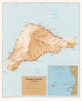
Also part of Chile are two notable Pacific possessions-the Juan Fernandez Islands and the famous Easter Island, both of which are administered as national parks. The Juan Fernandez islands are located about 670 km off the Chilean coast, while Easter Island is situated 3700 km distant.

7.7 Magnitude Earthquake Rocks Chile

A major earthquake struck northern Chile on Wednesday, toppling power lines, closing roads and sending terrified residents into the streets. Authorities reported some injuries but no deaths from the quake, which was felt in the capital as well as neighboring Peru and Bolivia.

The earthquake, which struck Chile at 12:40 p.m. local time (10:40 a.m. EST), measured magnitude 7.7 and was centered 780 miles north of Santiago, or 25 miles east-southeast of Tocopilla, the U.S. Geological Survey said.

The USGS said it occurred about 37.3 miles underground — relatively deep — which diminishes the destructive capability of quakes,

Tuesday, November 13, 2007

Geography Awareness Week (Nov. 11th-17th)

My Wonderful World, a National Geographic-led campaign for geographic literacy, and Google are working together to provide an interactive educational experience about our world. We are proud to celebrate Geography Awareness Week (Nov. 11th-17th), an initiative by National Geographic that promotes the importance of geography.

Each year, Geography Awareness Week has a different focus area. For 2007, the theme is "Asia: Continent of Contrasts." So whether you're a teacher, student, or armchair geographer, it's a great way to polish up your skills and learn all about Asia's fascinating cultures, natural wonders, animals and more.

Monday, November 12, 2007

San Francisco Oil Spill Maps

San Francisco Bay Oil Spill November 7, 2007. The Chinese-flagged Cosco Busan strikes the San Francisco-Oakland Bay Bridge, gashing the 65,000-ton ship's hull and spilling a estimated 58,000 gallons of fuel oil into the Bay. Aftermath of the oil spill. See the areas affected by the 58,000 gallons of fuel that spilled into the bay after a container ship rammed the Bay Bridge.

PacWind Turbines For The Home

Celebrities are getting on board with PacWind Turbines to turn their homes into green powered mansions. Jay Leno helped bring PacWind into the spotlight by powering his garage with their turbines.

PacWind Turbines are small, silent, and you can easily install them on your house or garage. PacWind has created revolutionary products that bring the infinite resource of wind energy into all the urban regions of our world, along with all of the rural and remote regions as well.

Sunday, November 11, 2007

Low Impact Living

As societies and corporations start to lean toward a more green output, it's crucial to have a source of information to make the right decisions. Low Impact Living can help you find the right environmental information to meet your individual needs.

Do you already know the green products you’re looking for? (shower heads, drip irrigation, composters)

Do you already know what room or area of your home you want to improve?

Do you want to learn more about green alternatives? (e.g., solar, wind, hybrids, etc.)

Answers like these can be found at Low Impact Living.

Black Sea Oil Tanker Sinks, Spills 1,000's Gallons Of Fuel

Another big shipping accident has left 560,000 of fuel leaking into the Black Sea. This follows last weeks spill in San Francisco, when a tanker collided with the Bay Bridge and spilled out its fuel. 2,000 tons of fuel oil had spilled from the tanker which broke apart in a huge storm in the Black Sea. A spill of more than 700 tons is considered large, but the biggest ones run into the tens or even hundreds of thousands.

Friday, November 09, 2007

San Francisco’s Bay Bridge Oil Spill

A couple of days ago a ship hit the Bay Bridge just outside of San Francisco and ruptured its hull. I was not aware at the time it but it leaked out 58,000 gallons of oil into the bay which has led Gov. Arnold Schwarzenegger to declare a state of emergency in the area to get it cleaned up.

San Francisco is one of my favorite places and I'll always remember it for all the sea birds, seals, sea lions, otters, and various creatures that make the situation that much more horrible to comprehend.

Although the San Francisco’s Bay Bridge Oil Spill remains largely inside the bay, tidal action and winds have spread the spill outside the Golden Gate and up the Marin County coastline, as far as Muir Beach.

Wildlife authorities said the number of birds caught in the sticky spill continues to climb, with 73 taken in for treatment and 19 found dead. Those numbers, authorities say, are likely to grow into the hundreds over the coming days. Scores of wildlife experts and volunteers are combing the shorelines for oil-blackened birds.

NOAA's Office of Response and Restoration is providing trajectory predictions to the Unified Command, which is led by the U.S. Coast Guard and includes NOAA, along with the U.S. Department of Interior and the State of California's Fish and Game Office of Oil Spill Prevention and Response.

There are several methods the oil spill response teams can use to clean up, it all depends on the type of oil, the weather and the habitat.

Today, they're using skimmers, a device that removes oil from the water's surface. The fuel that spilled into the San Francisco bay today is a nasty oil that breaks down slowly.

Crews also use these flexible floating booms to keep the oil from spreading into certain areas.

More than 200 workers and officials were cleaning up the fuel that leaked after the Cosco Busan container ship hit a base of the Bay Bridge near Treasure Island. The Coast Guard expected the clean-up force to double on Saturday.

Company uses satellite imagery to judge crops

A Chicago-based information company, Lanworth, Inc., is using twice-daily satellite images to look at crops.

With their technology and methodology, company officials hope Lanworth becomes a common name for pre-USDA forecasts.

Lanworth estimates the 2007 U.S. corn yield at 13.11 billion bushels and soybeans at 2.58 billion bushels. Their data was released five days before USDA released the official Oct. 12 report.

USDA's Oct. 12 numbers were 13.3 billion bushels for corn and 2.60 billion bushels for soybeans.

USDA's numbers were lower than some market analysts expected. (...continue article)

Remote sensing expert receives national award for teaching

Daniel Civco, a professor in the Department of Natural Resources Management and Engineering, has received a National Award for Excellence in College and University Teaching in the Food and Agricultural Sciences.

It is the highest honor an educator in the field of agriculture and natural resources can receive.

Civco, an expert on geomatics who specializes in remote sensing and Geographic Information Systems (GIS), was presented with the award on Nov. 11, during a meeting of the National Association of State Universities and Land Grant Colleges (NASULGC) in New York City. (...continue article)

Friday, November 02, 2007

What is C19A?

C19A is now the largest iceberg in the world.

Icebergs like C19A are named I believe in part to their coordinates on a map.

With an approximate size of 2,264 square miles in size, C19A became the largest iceberg in the world after the previous largest iceberg, B15 broke into two different pieces. The B15 weighed in at around 4,400 square miles in size. As the B15 iceberg continues to break up, the C19A takes the title of largest 'berg until it starts to cracks.

A giant crack across the B15 iceberg broke it off into two pieces in the last month.