
Here are some maps from the magical land of the Simpsons. Springfield, Anywhere, U.S.A. While Springfield is fictional it didn't stop mapmakers from building a replica of the cartoon town.
MAP OF SPRINGFIELD
The BIG Map of Springfield
Here are some maps from the magical land of the Simpsons. Springfield, Anywhere, U.S.A. While Springfield is fictional it didn't stop mapmakers from building a replica of the cartoon town.

 In another in a series of posts detailing how to create 'step inside panoramas' viewable in Google Earth we combine 3D models with panoramas to go inside the Tate Modern, London.

 Google Earth satellite images have unearthed Samsung’s top secret development of the World’s largest Plasma Television.
After Japanese manufacturer Matsushita topped the South Korean electronics company’s 102″ plasma with a 103″ model Samsung moved developments to the African country of Algeria where Matsushita’s spies wouldn’t know what they were up to.
Rather than risking another embarrassment Samsung have gone all out and developed a 4,975″ Plasma screen. However, this may have been a mistake - the TV is so big that it keeps falling onto its back.
Google Earth satellite images have unearthed Samsung’s top secret development of the World’s largest Plasma Television.
After Japanese manufacturer Matsushita topped the South Korean electronics company’s 102″ plasma with a 103″ model Samsung moved developments to the African country of Algeria where Matsushita’s spies wouldn’t know what they were up to.
Rather than risking another embarrassment Samsung have gone all out and developed a 4,975″ Plasma screen. However, this may have been a mistake - the TV is so big that it keeps falling onto its back.


 Textured 3D buildings in the Miami area are beginning to appear in VE. We've also just published birds eye imagery for Miami and Miami Beach. The BE imagery is so high res that if you look really really close you can actually see an episode of girls gone wild being shot.
 PRAISE ESRI!
 Google Australia is celebrating Australia Day 2007 by photographing Sydney Harbour from the air, and we want to make sure as many of us as possible squeeze into the picture.
 Some O'Reilly FOO Camp attendees took advantage of an announced Google fly-over to make their mark on Google Maps and Google Earth with some Space Invaders inspired artwork.
 A species of shark rarely seen alive because its natural habitat is 600 metres (2,000 ft) or more under the sea was captured on film by staff at a Japanese marine park this week.
Marine park staff caught the 1.6 metre (5 ft) long creature, which they identified as a female frilled shark, sometimes referred to as a "living fossil" because it is a primitive species that has changed little since prehistoric times.
 Very cool satellite image of a SR71 Black Bird on an Aircraft Carrier via Google Maps!!!
 From Vanity Fair's 2006 Year in Pictures comes an eco-photo rendition of what Manhattan might look like if sea levels continue to rise
 You may recall the long and winding tale of David Schneider, the man behind the SharkSkunker chemical shark repellent. In order to prove his invention worked the way he hoped it would, he needed to capture footage of sharks being scared away by his repellent.


 The Concorde is no more. After 30 years of service, the famous jet hit rock bottom after a fatal crash in France that killed all on board and several people on the ground. Since then the fleet has been grounded and officially retired.
 Inside story: secret test tracks
 Using NASA's Chandra X-ray Observatory, scientists have created a stunning new image of one of the youngest supernova remnants in the galaxy.
  This chart shows various religions plotted on a map of the World as well as the percentages of believers and non-believers.
 ![]()

 The Dubai Waterfront will be the largest in the World after completion with over 100 different waterfront developments and over 150 master planned communities and Dubai Waterfront will be bigger than Manhattan and Beirut.

 Approx. 15-25% of the World's Cranes are in Dubai!
By now, you probably know about my fascination with all the construction going on in Dubai. In what will not doubt be recognized as the largest building boom in the last century, Dubai is on tap to build not only the tallest skyscraper (and 2nd, if plans go right), the world's first 7-star hotel, a series of private islands shaped like palm trees and a globe, an underwater hotel, the first ski resort in the Middle East, the largest mall, and a ton of condos and private communities.
To get an idea of how much the building boom has gripped the area, look at this picture of Dubai taken from the 90's and a new one taken a year ago:


Throw in this huge, extra-fancy hotel that bills itself a the world's only 7-star hotel, The Burj al-Arab.

The iPad is a luxury condo inspired by the iPod. Serious!

Dubai set the bar higher by creating The Palm, a series of private islands shaped like a palm tree and visible from satellites. The Palm was such a success before it opened, that more islands were started. There's even one shaped like the world. Click here for satellite image of Dubai from 1973-2006!


 The Burj Dubai

The Al Burj
Thanks to Dubai is nuts for additional pictures.
 From the Google Earth Community (click link for more info):
 This article would be better with pictures. I know, I hate to be 'that person,' but seeing the riches of the Antarctic is priceless.
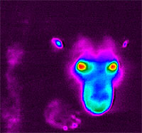 A few years ago, scientists doing an aerial census of the polar bear population in the arctic encountered a problem. The polar bears being counted were hard to spot because their white fur blended into the snow. Scientists decided to use infrared, heat sensing technology for the survey, but found that curiously, the polar bears became invisible. Scientists could see the eyes, nose and breath, but not the bear.
