If you've seen the new Hummer commercials with the bad magician, then you'll this clip. I had this uploaded in May and when I saw the HUMMER commercials with the magician I rolled over laughing. This guy is hilarious. Enjoy!
If you've seen the new Hummer commercials with the bad magician, then you'll this clip. I had this uploaded in May and when I saw the HUMMER commercials with the magician I rolled over laughing. This guy is hilarious. Enjoy!
He has a day off and needs milk for his cereal, so he goes to the store.
 A couple of GIS LINKS to mention. I have added links for Lincoln County GIS and St Joseph City GIS to the wonderful state of Missouri. The links have also been added to GIS PILOT.
"When most people use virtual globe Google Earth, they look up such sights as Sydney Opera House, Big Ben or even their own homes.
But two of the computer program’s users got an extra surprise when they explored the Dutch city of the Hague - and spotted topless sunbathers. A Dutch blogger looking for his favourite pub accidentally zeroed in on a man wearing just ..."(continue article)
NEW YORK (Reuters) - Wei-Ming Kao approaches a heavily guarded truck in a secluded parking lot in an industrial area of New York to pick up his orders -- to "stalk" and "kill" his target.
But all is not what it seems.
Kao, 27, a graduate student, is playing "StreetWars," a version of a popular high school and college game "Assassins" that kicked off in New York on Monday with around 240 players.
Kao is given a photo, name, home and work addresses and phone number of a target whom he must pursue and "kill" with a water pistol, water balloon or other water-based soaking, while eluding the player who is coming after him. ...(continue article)
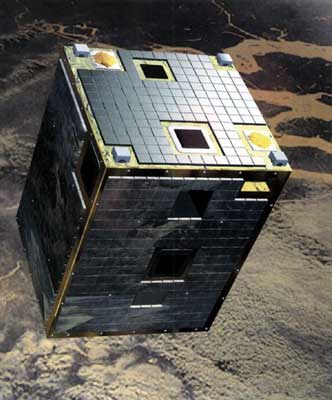
"ESA’s microsatellite playing major role in scientific studies
ESA's smallest Earth Observation satellite, Proba, is making big contributions to science with applications ranging from environmental monitoring, agriculture, forest , land use, crop forecasting, marine and coastal science as well as biological soil crusts and solid waste landfill monitoring.
Launched on 22 October 2001, Proba orbits 600 kilometres above the Earth and acquires around 450 scientific image datasets of more than 100 separate sites each year. Its main payload, the Compact High Resolution Imaging Spectrometer (CHRIS), is a highly configurable hyperspectral imager that sees down to a resolution of 17 metres and can acquire up to five images of a desired target at a time, each at a different angle with respect to Earth's surface, because Proba is ... (continue article)"

With a quick click of the mouse, tourists can find the location of and information about local restaurants, hotels, attractions, bike trails, covered bridges, parks, libraries, universities and hospitals throughout the region.
Click on the restaurant, hotel or other attraction you're looking for in the vertical menu along the right side of a map. The map then zooms in on the location and with another click offers ...(continue article)
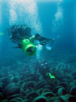 Artificial reef made of tires becomes ecological disaster
 What began 30 years ago as an idealistic plan to shape an artificial coral reef has become an underwater wasteland BY TRENTON DANIEL
tdaniel@MiamiHerald.com"A plan in the early 1970s to create a massive artificial reef off Fort Lauderdale has turned into an environmental mess with the U.S. Navy, Broward County and others trying to figure out how to remove about two million tires covering 36 acres of ocean floor. What was intended to lure game fish now is damaging sensitive coral reefs and littering Broward's tourist-populated shoreline.
''They thought it would be a good fish habitat. It turned out to be a bad idea,'' said William Nuckols, project coordinator and military liaison for Coastal America, a federal group involved in the cleanup. ``It's a coastal coral destruction machine.'' The tires dot the ocean bottom a mile and a half from... (continue article)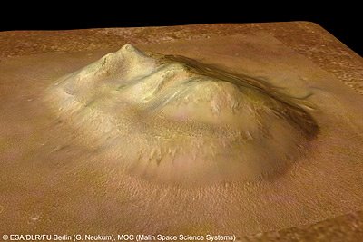
(From Spaceref.com) ESA Mars Express Iimage: Cydonia - the face on Mars
 KNOX COUNTY GIS (KGIS) has been kind enough to inform me that they have added a beta version of SEVIER COUNTY, TN GIS to their list. KGIS already runs on of the best GIS sites we use on a daily basis and trust me when I say there many, many sites out there that need to take lessons from KGIS on how to incorporate user interface, layers, and search features. KGIS also says to keep an eye out for JEFFERSON COUNTY, TN GIS. It's not up yet, but will be in the future.
Agency will be updating maps for navigation
"The National Oceanic and Atmospheric Administration has begun surveying and mapping marine hazards in Mississippi's waterways, an agency representative told the state's Commission on Marine Resources on Tuesday.
"We started last week in Mississippi to make accurate maps for navigation," Osborn said. "Right now, we are primarily working on navigation channels. Even small hazards can create a serious risk to commercial fishing and recreational boating." NOAA contracted Louisiana's C&C Technologies for the project, which is using side scan sonar instruments to find submerged hazards.
Osborn said the equipment found 400 submerged objects in a 40-square-mile test area. Project technicians are first completely scanning Biloxi's Back Bay. Afterwards, they will move on to St. Louis Bay and other bays. They will also scan near-shore waters, but will only go into deeper parts of the Sound when they are following large debris fields with the sonar." (...continue article)
I've added this site to both GIS SITES BLOG and GIS PILOT.
The Asheville Citizen-Times reports of Asheville's new GIS site:ASHEVILLE – The city of Asheville announced today the introduction of a mapping tool online allowing people to view, manipulate, measure and print maps of parts of the city.The public also can use mapAsheville to search for a piece of property by its address or its owner's name.

This fall's new television brings about a new form of television viewing. As more and more people are stuck behind a computer for most of the day, and more young people are turning to their computers rather than TV, the aspect of watching your favorite television programs and movies on your computer just got easier.
After some trials, streaming shows online and allowing a viewer to pick when they want to watch it has gained popularity. In a TiVo-world, the choice of when and what to watch is now important. ABC had the most visible test when they offered shows like "LOST" and "GREY'S ANATOMY" online for about 6 weeks in late spring. Their ESPN branch streamed the playoffs of the WORLD CUP from Germany online to much success in June. CBS increased their internet traffic to the NCAA Men's Basketball playoffs from: "about 25,000 with the 99 cent fee to "hundreds of thousands" when they were free. The larger audience allowed the network to earn about $4.5 million in extra advertising revenue,..."

Ahhhggg!
Monday is here!
Anyway, here's some news floating around the geography world:
 Florida is getting an injection of oysters in the St. Lucie River as thousands of oysters are farmed and let go into deep water reefs.
"This week, the 98,000 oysters that scientists and waterfront homeowners started raising in mesh bags in June will be scattered over natural reefs in the St. Lucie River to augment the struggling local population"
www.gispilot.com
Florida is getting an injection of oysters in the St. Lucie River as thousands of oysters are farmed and let go into deep water reefs.
"This week, the 98,000 oysters that scientists and waterfront homeowners started raising in mesh bags in June will be scattered over natural reefs in the St. Lucie River to augment the struggling local population"
www.gispilot.com
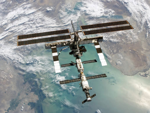
The INTERNATIONAL SPACE STATION (ISS) received a new set of solar wings from the Space Shuttle that will not only provide more power but will also make the ISS one of the brightest objects in the night sky. The glow that reflects off of the panels will create an object near the intensity of Venus. Below are links to related sites that will allow you to track the ISS in the night sky and find out when it passes over your neighborhood again. The Heavens-Above site has real-time tracking of the ISS over the earth.
 The 2010 Census is coming on strong and may see the largest growth of minority populations recorded in Census history as the Hispanic population grows to record rates. With issues of immigration and citizenship for illegals on the front burner, expect this issue to dominate the headlines of the Census process. Just a prediction.
 I really feel for this guy trying to get info out of the city. Most of the government bodies we deal with in a given day are helpful, but every now and then we crash into the "Wall of Red Tape," and get that one city, county, or town that just will do everything they can to NOT help us. I am also amazed that we still have to PAY for information that is constructed and supported by TAX $'s. I understand copy fees, but there are some greedy government bodies out there.
  It's hard to research GIS related material without running into the brick wall that is "GOOGLE EARTH." Google reaches further into the world of Geography by adding a new round of improvements and advances with a new update of features for GOOGLE EARTH. Also, a couple of links to mapping news.

GIS SITES and GIS PILOT - We're close to the 2,000 link mark now. GIS PILOT has topped the 1,800 mark and should be around the 1,900 mark for links in a month or so. Thanks for all the links that readers have submitted. Keep up the good work. If you have a link or suggested site, go to GIS PILOT and submit it there.

 Thanks to a reader for finding the Cobb County, Georgia GIS site which I have added to this site as well as GIS PILOT. I had the Assessor site up already and I will leave that for reference.
 About 6 months ago it was leaked that a full screen iPod was in the works and set to release in the year. Apple has finally claimed due to various technical reasons, the battery life being the main one, that the full screen iPod will not be released for awhile. The full screen iPod is pretty snazzy, too. It features a touch pad that is built into the screen itself to allow for all the regular features of the regular iPod. The real push for the new iPod was to allow for full length feature films to be downloaded off iTunes and viewed in widescreen mode. Until the new, full-screen iPod does make it to the stores, we'll have to settle for movies on the regular iPod video. Tuesday marks the announcement of the addition of downloadable movies to the iTunes site.
 I have added the MISSOURI DEPT OF NATURAL RESOURCES site to GIS SITES and GIS PILOT.
This is a good resource site for any water related maps and information, namely permits for properties and subdivisions. It gives me an extra source for finding legal descriptions and info for properties I have to research at work. Usually, if I can find the property that has been submitted for a permit, the legal description is very good. They had a GIS link on the menus last week, but as of this post it was taken off. I hope they put it, or something related, back up.
I have added the MISSOURI DEPT OF NATURAL RESOURCES site to GIS SITES and GIS PILOT.
This is a good resource site for any water related maps and information, namely permits for properties and subdivisions. It gives me an extra source for finding legal descriptions and info for properties I have to research at work. Usually, if I can find the property that has been submitted for a permit, the legal description is very good. They had a GIS link on the menus last week, but as of this post it was taken off. I hope they put it, or something related, back up.

 Let's start the week off right, with the "BIG LEBOWSKI" random quote generator for those that need a quick laugh.


