- World Cup viewers may top 30 billion
- 1,280 lb Hammerhead Shark Caught & Pregnant
- France Rules Apple iPod's must share songs
- ESPN streams 2006 FIFA World Cup Online
- Cellphone talkers as bad as drunk drivers
- Woman auctions herself with her Ferrari
- Drive-thru pot smokers Busted at KFC!
- Drunk NBA player crashes SUV while watching porn and touching himself!
Friday, June 30, 2006
Daily Headlines
Here's some of the more interesting headlines for the day:
Watch the World Cup Online - Live US streams
 I don't know how long ESPN has been streaming a live feed of the 2006 FIFA World Cup from Germany, but it's up now. I looked before the games started and found nothing, so either I missed it or it's new. It doesn't really matter now-the US team cracked and lost. Fridays games have Germany v. Argentina at 11:00 EST and Italy v. Ukraine at 3:00 EST.
Go to www.ESPN.com and it'll be on the main page. If not look for ESPN 360 link.
I don't know how long ESPN has been streaming a live feed of the 2006 FIFA World Cup from Germany, but it's up now. I looked before the games started and found nothing, so either I missed it or it's new. It doesn't really matter now-the US team cracked and lost. Fridays games have Germany v. Argentina at 11:00 EST and Italy v. Ukraine at 3:00 EST.
Go to www.ESPN.com and it'll be on the main page. If not look for ESPN 360 link.
Thursday, June 29, 2006
Watch NASA-TV Live and View the Space Shuttle in Orbit
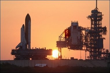 Yahoo! has done a great job in bringing the NASA channel and various space missions to the web. There is a stream of NASA-TV linked to Yahoo as well as various articles and followings in conjunction with Space.com.
This week, the Space Shuttle Discovery jumps into the heavens and can be seen, due to its low orbit and clear weather, from the Earth. Also, the ISS (International Space Station) will be visible as well. Check out the main Space Shuttle page on Yahoo! for more details.
Yahoo! has done a great job in bringing the NASA channel and various space missions to the web. There is a stream of NASA-TV linked to Yahoo as well as various articles and followings in conjunction with Space.com.
This week, the Space Shuttle Discovery jumps into the heavens and can be seen, due to its low orbit and clear weather, from the Earth. Also, the ISS (International Space Station) will be visible as well. Check out the main Space Shuttle page on Yahoo! for more details.

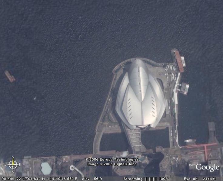
UFO Lands in Hong Kong - Satellite Picture Proof!
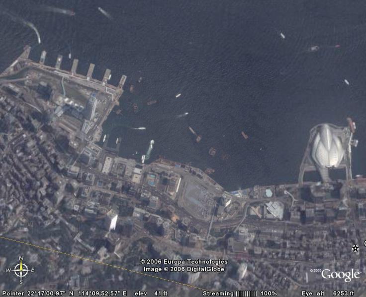 I'm not too sure what this structure is, I haven't really looked into it. But, by my professional eye, it's a docking port for UFO's. They like Honk Kong for the Kung Pow Chicken and visit regularly. Or not.
Panama Canal Satellite Image
 Fun with Google Earth. Here ships are passing through the southern part of the Panama Canal. The canal actually runs in a SE direction, so this is the southern most part and the eastern most part at the same time as the canal meets the Pacific Ocean.
Wednesday, June 28, 2006
I'M HUGE IN INDIA T-SHIRTS
 Here's a funny T-shirt I made. It's "I'm Huge in India" in relation to all the outsourcing and stuff for GIS jobs. You can find them at http://www.cafepress.com/hugeinindia
Latest Design for Freedom Tower Released
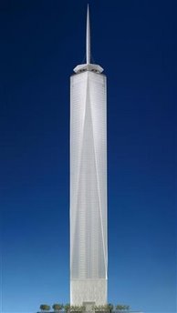
Freedom Tower

Artist rendering
Tropical Stonehenge Found in the Amazon
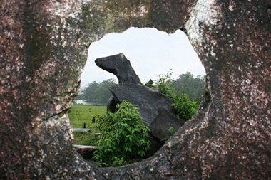

The AP reports of a rather unusual finding in the Amazon in the form of a centuries-old astronomical observatory similar to that of Stonehenge. The discovery adds to the mysterious nature of the Amazonia Rainforest inhabitants and also to the unusual sophistication of early cultures in the new world like the Mayans and Incas.
The finding unearths blocks of granite lined up to match the seasons and the stars. On December 21, the shortest day of the year, "the shadow of one of the blocks disappears when the sun is directly above it." The importance of the blocks indicates the relations of the inhabitants to their environment and the creation of a seasonal calendar. Knowing the seasons and the changes in the environment is crucial to agriculture and other lifestyles. The Mayans at Chichen Itza created the temples below to reflect similar seasonal displays.
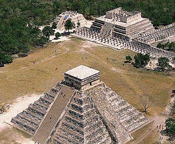
Chichen Itzu Temples
The main temple above, the Temple of Kukulcan or El Castillo, is aligned with the fall and spring equinox and forms a visual calendar by creating a shadow on the stairs in the shape of a serpent's tail. The head, located at the base of the stairs (one for each day of the year), has a 'shadow' tail created by the seasons that grows and shrinks with the seasons. When it hits the bottom, the winter is there and at it's length the spring equinox is in full.

Serpent's head
World Cup Fans Drinking Germany Dry!
 The 2006 FIFA World Cup in Germany is taking its toll on the beer. Germany is warning fans it might not have enough beer for the final matches that will occur over the next 2 weeks. At the heart of the consumption are the English fans who have hit Nuremberg rather hard.
The UK Mirror reports : "In Nuremberg, organizers revealed 70,000 England fans who flooded the city drank 1.2MILLION pints of beer - an average of 17 pints each"
Nice one!
Also: "Astonished bar keeper Herrmann Murr said: "Never have I seen so many drink so much in such little time."
His bar at a fans' tent in the city ran out after they drained all 32 of his 50-litre (11 gallon) barrels"
It goes to show you how much beer is being consumed when the country hosting has a annual festival dedicated to drinking beer and still runs OUT! I just hope they recover in time for Oktoberfest.
UK Mirror
The 2006 FIFA World Cup in Germany is taking its toll on the beer. Germany is warning fans it might not have enough beer for the final matches that will occur over the next 2 weeks. At the heart of the consumption are the English fans who have hit Nuremberg rather hard.
The UK Mirror reports : "In Nuremberg, organizers revealed 70,000 England fans who flooded the city drank 1.2MILLION pints of beer - an average of 17 pints each"
Nice one!
Also: "Astonished bar keeper Herrmann Murr said: "Never have I seen so many drink so much in such little time."
His bar at a fans' tent in the city ran out after they drained all 32 of his 50-litre (11 gallon) barrels"
It goes to show you how much beer is being consumed when the country hosting has a annual festival dedicated to drinking beer and still runs OUT! I just hope they recover in time for Oktoberfest.
UK Mirror
Tuesday, June 27, 2006
Guantanamo Bay, Cuba US Military Base Satellite Image and pictures
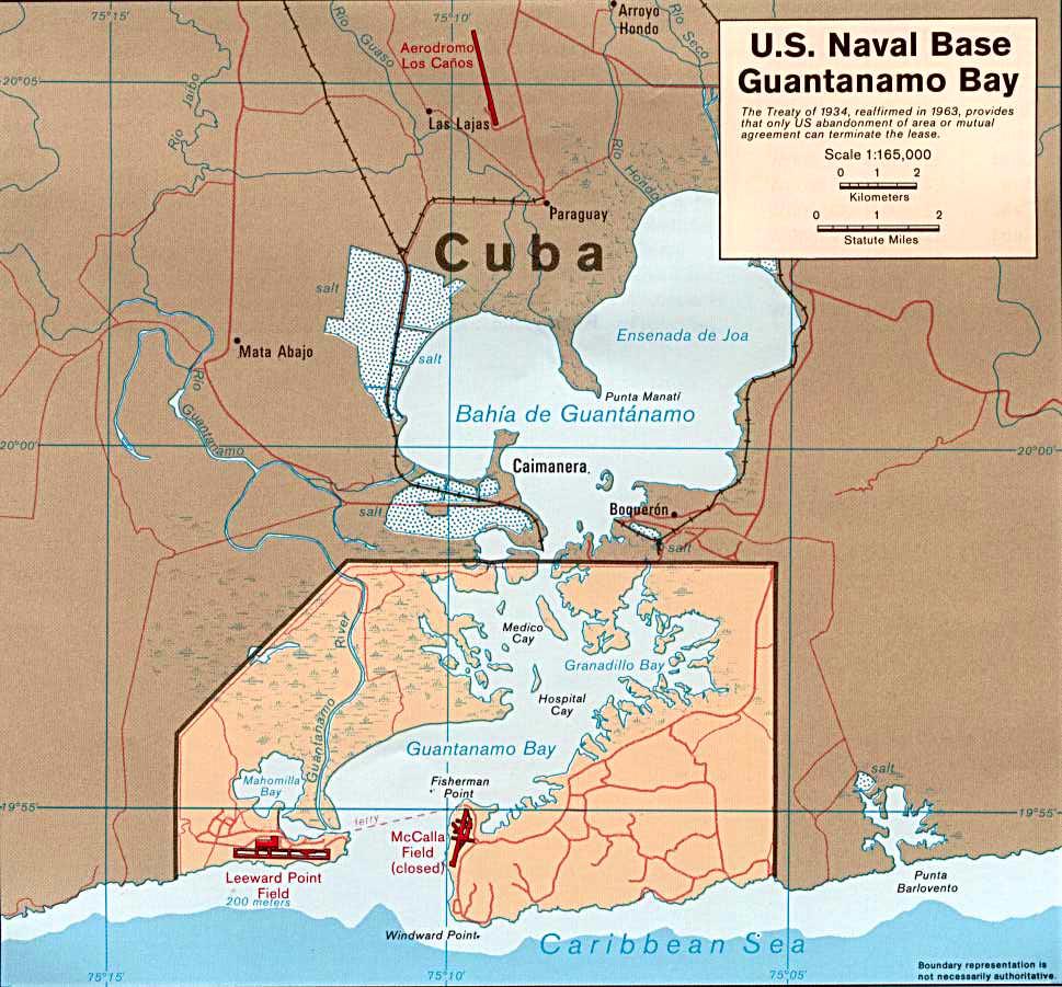 When the Cubans gave the United States a permanent lease to the lands of Guantanamo Bay, Cuba, they had no idea what they were in for. It is considered a Naval Base in official status, but is also a detention area for many criminals against the United States, which I don't think I need to elaborate on. In general, the land lies in the southern tip of Cuba and is outlined in the map above. Play around with the Google Map Satellite image and see what you find!
Wow! That can't be good for the environment.
Here's a satellite image of Jamaica showing some rather unsightly goings on.
IKONOS Images of Ancient Observatories
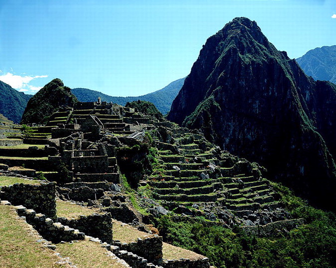 Here's another post from GIS for Archaeology about the IKONOS website where they have a nice page to view Ancient Civilizations. It was nice to see they added one of my favorite sites, Chichen Itza, from Mexico, and also another site I want to see but haven't, Machu Picchu. You might know Machu Picchu from it's breathtaking pictures like the one above. Both are fabulous sites with a wealth of information to curious visitors. Here's more from GIS Arch article:
- IKONOS Images of Ancient Observatories
- From Space Imagery, a provider of space and aerial remotely sensed images, comes a fun Flash map application which maps 13 of the world’s Ancient Observatories. From Abu Simbel (wiki link) in Egypt to Uxmal (wiki link) in Mexico, the Ancient Observatories map application displays a zoomable/pannable high resolution images of a particular observatory accompanied by a text description of the sites history and significance. The images can be downloaded and are linked to their metadata source.The logic of this application brings full circle some pretty interesting ideas about ancient and modern technology. Do you think we can learn more about ancient observatories from studying them from the celestial point of view. Perhaps my fascination is simply coming from the “Who’s watching the deceive” feeling of this application. Either way, it’s very cool and well worth a look
Satellite Image of Baghdad, Iraq
 بغداد
The satellite image of Baghdad, Iraq, shows the Tigris River carving its way through the desert. The city of Baghdad is the second largest in the middle east with over 5.7 million people.
بغداد
The satellite image of Baghdad, Iraq, shows the Tigris River carving its way through the desert. The city of Baghdad is the second largest in the middle east with over 5.7 million people.
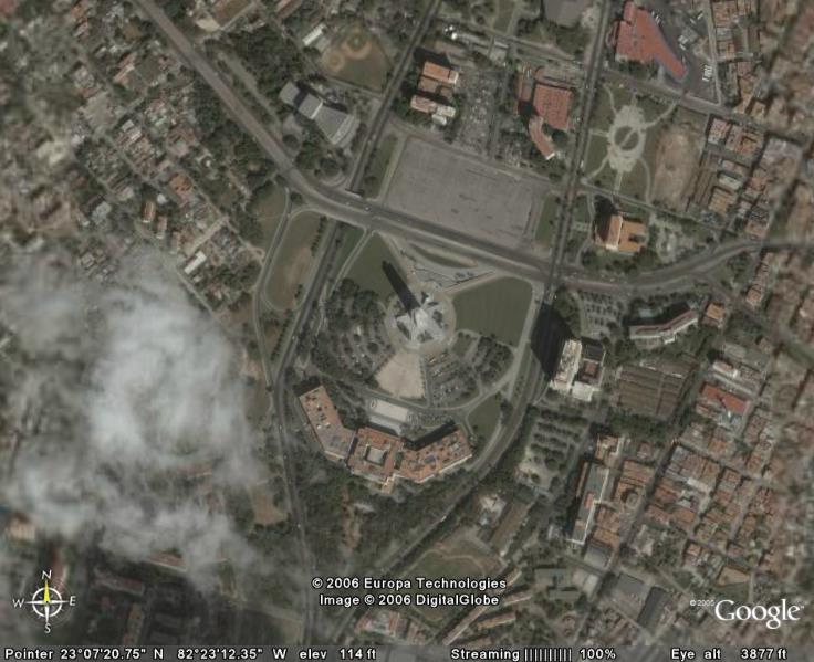
Vatican Satellite Image

A birds eye view of Vatican City, Italy. The identifier is Saint Peter's Square and Basilica which is the open, circular space in the middle, west half. At the center of that is an obelisk, which if you have read "The DiVinci Code" by Dan Brown too many times you will know it's link to conspiracy theories. The Vatican City is the smallest independent nation in the world at 108 acres big.
Heavy Metal jumps the Shark-Kiss opens a Coffeehouse!?
 Apparently, this is real.
Rap jumped the shark when P Diddy rapped with Martha Stewart and now Metal joins the pack with the grand opening of the hard core, devil-inspired, blood dripping...Cafe Mocha?That's right! The heavy metal band "KISS" is opening a Coffee House.

Monday, June 26, 2006
Giant Asteroid heads toward Earth.
 July 3rd marks the passing of an Asteroid close to the Earth's orbit. There's no need to panic and run for the hills, but it's always a good excuse to run over to some pretty girl, tell her it's your last minute on Earth, and then kiss her. Then run away.

Don't Worry Ladies-I'll Protect You!
The Asteroid, known by its stage name Asteroid 2004 XP14, is about 1/2 mile wide and will serve as fodder for astronomers for years to come as it swings past the moon's orbit at 268,624-miles (432,308 km), or just 1.1 times the Moon's average distance from Earth. Also, I have included an article by Dave & Thomas in reaction to a guy that wrote "10 Ways to Destroy Earth." Enjoy!
Sunday, June 25, 2006
Panoramic Toronto at Night
 I was cruising through some photos online and found Smaku's gallery with this nice picture of Toronto at night. He's got some nice pictures of his travels at this gallery so be sure to drop by.
Friday, June 23, 2006
GIS Sites New Design.

For those of you that are regulars, You will have noticed a change in the format of GIS Sites. I have adopted a 3 column format over the regular 2. This allows for the links for the states to be put on the side instead of on the top and the links and stuff of that nature to still have their own column.
Also, all 12 stadiums are up for the 2006 FIFA WORLD CUP @ www.gispilot.com/blog.
Enjoy!

Thursday, June 22, 2006
World Cup Stadium Satellite Images and Pictures.
 Part 4 of 4 of the 2006 Germany FIFA World Cup Stadium Satellite images and pictures is up at www.gispilot.com/blog.
Enjoy!
Part 4 of 4 of the 2006 Germany FIFA World Cup Stadium Satellite images and pictures is up at www.gispilot.com/blog.
Enjoy!
http://gispilot.com/blog/2006/06/world_cup_arenas_part_iv_stadi.html

Wednesday, June 21, 2006
New Jersey GIS Update
 I have added 2 New Jersey sites:
City of Vineland, New Jersey GIS
City of Millville, New Jersey Tax Maps.
WWW.GISPilot.com
I have added 2 New Jersey sites:
City of Vineland, New Jersey GIS
City of Millville, New Jersey Tax Maps.
WWW.GISPilot.com
Tuesday, June 20, 2006
Major League Baseball Blackout Map.
 If you have ever wondered why you can't watch you local team and you hear the term "blackout" then I have the map for you. "Blackouts" refer to NOT showing a local team in a local market to encourage people to go to the games. In theory, if you live in Atlanta and the Braves have not met the "Blackout" rules, usually 'x' amount of tickets sold before a game, then the Braves would be "blacked out" on you television broadcasts. New technology and television standards have made the "Blackout" rules outdated and with the advent of Internet streamed games that advertise being able to watch games online, MLB must reconfigure its "blackout" standards.
For example, if you live in Iowa, you are being blacked out of 6 teams from 4 states. "Blackout" rules make a St. Louis fan anywhere in Oklahoma unable to watch games when they are "blacked out" even in western Oklahoma where you would be closer to 2 other teams in 2 states that aren't blacked out.
www.gispilot.com
If you have ever wondered why you can't watch you local team and you hear the term "blackout" then I have the map for you. "Blackouts" refer to NOT showing a local team in a local market to encourage people to go to the games. In theory, if you live in Atlanta and the Braves have not met the "Blackout" rules, usually 'x' amount of tickets sold before a game, then the Braves would be "blacked out" on you television broadcasts. New technology and television standards have made the "Blackout" rules outdated and with the advent of Internet streamed games that advertise being able to watch games online, MLB must reconfigure its "blackout" standards.
For example, if you live in Iowa, you are being blacked out of 6 teams from 4 states. "Blackout" rules make a St. Louis fan anywhere in Oklahoma unable to watch games when they are "blacked out" even in western Oklahoma where you would be closer to 2 other teams in 2 states that aren't blacked out.
www.gispilot.com

Burj Dubai - Tallest Skyscraper Webcam

Although it's still a year away from being completed, the Burj Dubai, the soon to be world's tallest skyscraper, is taking shape. They have an aggressive website that updates the buildings height as well as skyscraper news around the world, namely other buildings trying to claim the world's tallest title. A new outline of the building is highlighted in red with the building progess and a webcam updates pictures of the construction. 3-D renderings of the site plan and skyline are an added feature.
Also, a GIS site for Dubai is up but not operational yet. I have posted a link on www.gispilot.com under the "World Countries" section. The same message has been up for a month now and I do not know when it will be operational. However, the link is there for your other mapping needs on Dubai.
On the web:
www.GisPilot.com
Friday, June 16, 2006
Satellite images of Dubai & The Palm (Island of sand)

Satellite image of The Palm

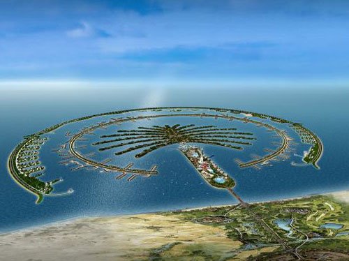
The Palm has updated their website to include new photos as their construction takes shape. The Palm can be summed up as a man made subdivision in the shape of a palm tree. The trick is that it's built in the Persian Gulf using sand.

Click for hi-res: you can see the dredgers at work building the island.
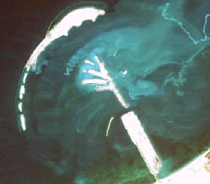
During the construction
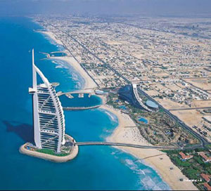
Burj-al-arab Hotel

Click for hi-res - Burj-al-arab Hotel
Dubai's goal is to be the recreation site of the world. The World's largest skyscraper are being built here as well as the World's largest man-made islands, like the Palm. So far, popularity is so high that there are islands being built in the shape of the world as well as another, larger palm tree with leaves. (See Previous Post: Livin' in a Palm tree in Dubai!) The Burj-al-Arab hotel is considered the finest in the world, offering a private and spoiled stay in a hotel built in the Gulf. The hotel was built in 1999 and the design is modeled after a sail from a boat as it catches the wind. Rates start at about $1,000/night and it is considered the only 7-star hotel. Yes, it's so fancy they made more stars on the rating system to accommodate it. There are plans in Dubai for an underwater hotel, theme parks, and various other skyscrapers.
Dubai-UAE
Wednesday, June 14, 2006
World Cup Stadiums 3
 Germany 2006 World Cup Stadiums Satellite Images Part 3 up at
WWW.GISPilot.com/blog
Germany 2006 World Cup Stadiums Satellite Images Part 3 up at
WWW.GISPilot.com/blog Hurricane simulator.
It's that time of year again when the Atlantic Ocean starts up trouble. This year marks the first wave of storms since last years tragic hurricanes that swept through the south. For those that would like to know what the scales mean and how the react to the environment (and your house), I have found a hurricane simulation.
Tuesday, June 13, 2006
 Stadium pics and Satellite photos #2 for GERMANY 2006 WORLD CUPS STADIUMS up at WWW.GISPILOT.COM/BLOG
(Blogger's being difficult, so they're being posted there for the time being)
Subscribe to:
Posts (Atom)