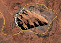
 Google Maps is bringing their Traffic Road-Show to their main, mapping applications. Before it was just available on the mobile version and rival Microsoft has had a layer out for months on their local live. I think Yahoo! Maps has a version, but I've never played with it. Anyway, give it a whirl and see if it matches up.
Wednesday, February 28, 2007
Google Maps Shows Real-Time Traffic Data
Google Maps is bringing their Traffic Road-Show to their main, mapping applications. Before it was just available on the mobile version and rival Microsoft has had a layer out for months on their local live. I think Yahoo! Maps has a version, but I've never played with it. Anyway, give it a whirl and see if it matches up.
HUGE UNDERGROUND OCEAN FOUND BENEATH ASIA
 National Geographic is publishing the finds of an underground "ocean" beneath Asia that helps prove there's a lot we just do not know about this world of ours. The moisture is actually being held in rocks about 400 miles below the surface. The size of the mass is equivalent to the Arctic Ocean and will no doubt drive scientists crazy for awhile as they ponder the "oceans" existence.
The guts of the Earth can be "seen" by scientists who study seismic waves after earthquakes. The water got there through plate tectonics, scientists figure and this process caused the ocean bottom to be pulled beneath continental plates all around the Pacific Rim. Now, that's pretty cool.
Monday, February 26, 2007
THE GENTLE GIANT: OCEAN SUNFISH
 The ocean sunfish (mola mola) is the largest bony fish in the world. It is a unique pelagic fish, and specimens of ocean sunfish have been observed up to 3.3 m (11 ft) in length and weighing up to 2,300 kg (5,100 lb).
 Curiously, the Ocean Sunfish has a very small brain compared to its size: A 200 kg specimen may have a brain the size of a nut weighing only 4 g. It would explain their quiet behaviour and how often they get trapped into fisher nets.
According to the National Geographic if it lives to adulthood, a sunfish can gain over 60 million times its starting weight: "the equivalent of a healthy, bouncing human baby growing to a weight equal to six Titanics".

CRAZY ROAD INTERSECTIONS

They are called the "Malfunction Junctions", or "Spaghetti Intersections", and they are located almost in every major city in the West. You can find the streets that end nowhere, streets that strangely allow traffic in both direction (without providing proper lanes), streets that change names more often than a communist Cold War spies.
Sunday, February 25, 2007
WEATHER.COM INTERACTIVE MAP

I'll give this one a mention because I was told to expect the new interactive map from Weather.com. I don't frequent the site enough to tell you when they have created this new style, but I was told it came out this month.
Classic reasons why man should never mess with mother nature

The killer bees and Nile Perch are just a couple of reasons why man shouldn't mess with nature. When we tinker with the system there stands a chance that we'll mess up the balance. Proof of that rests with these examples.
Strange New Creatures Found in Antarctica
 Several strange creatures including a psychedelic octopus have been found in frigid waters off Antarctica in one of the world’s most pristine marine environments.
 Others resembled corals and shrimps. At least 30 appear to be new to science, said Julian Gutt, chief scientist of an expedition that was part of the International Polar Year research effort set to launch on March 1. The researchers catalogued about 1,000 species in an area of the Antarctic seabed where warming temperatures are believed to have caused the collapse of overlying ice shelves, affecting the marine life below.
“This is virgin geography,” said expedition member Gauthier Chapelle. “If we don’t find out what this area is like now following the collapse of the ice shelf, and what species are there, we won’t have any basis to know in 20 years’ time what has changed and how global warming has altered the marine ecosystem.” [continue article]
Tuesday, February 20, 2007
GIS LINKS

I have updated, or I should say started to update, my GIS PILOT site. I want to thank all those that have submitted links that I have missed or are broken. I also wanted to make an announcement that my favorite GIS site KGIS (which is located in Knoxville, TN, where I live) has put their latest addition to the GIS world online in the form of the Jefferson County, TN GIS site. They've done a great job, as usual, and I have added the link to the Tennessee GIS LINKs page on GIS PILOT.
2007 TENNESSEE GIS CONFERENCE

Highlights of the city include the famous Chattanooga Aquarium
The 2007 TNGIC CONFERENCE in Chattanooga is the premier GIS event for anyone involved with GIS in the state of Tennessee. The event will feature over 40 vendors with over 400 attendees and will run this April 17-18 at the Chattanooga Convention Center. If you would like to meet people in the GIS field and interact with the newest vendors and technology make sure to book the event early for the best prices. If you are submitting a paper, check with the website for deadlines and contact info.
Presentations:
Planned and confirmed presentations include submissions by County and Local Government (Wilson County, Rutherford County, Hamilton County), State Government (OIR GIS Services, TWRA, TDEC), Federal Government (USGS, TVA, USFWS, Dept of Agriculture, Homeland Security, U.S. Census), Education (UT Knoxville, UT Chattanooga, Delta State University, MTSU, Austin Peay) and Private Industry (ESRI, Earth Data, GeoJobe)
Some special events to keep to book early include:
- ESRI 2-Day Introduction to ArcGIS Server Course, taught by ESRI Instructor
- Mobile GIS Fundamentals
Monday, February 19, 2007
CROCODILE HUNTER IN GOOGLE EARTH

The 3D download for the Sydney Opera House has a little bonus on it's shore front. The Crocodile Hunter, Steve Irwin, makes and appearance with his pet croc!

TOURIST INSIDE TOKYO TOWER ON GOOGLE EARTH
 You can download the Tokyo Tower from the Google 3-D warehouse and get a little visitor included. Inside the tower is a tourist (below) that is in the bottom of the tower. With the 3D objects, you can go through them. Do this for the tower and in the bottom is the tourist.
EASTER ISLAND ON GOOGLE EARTH

 I don't remember Easter Island being this detailed on GOOGLE EARTH when I first checked on it. However, GE updates a lot and it was what seems like years ago when I first started playing on GE.
 One of the cool things about GE is how well they have incorporated information into their mapping. I like how over the last year they have really incorporated pictures into their layers without having to go download anything.
The Easter Island maps are no different. They have lots of images of the little stone dudes for you to view. Click on their pictures to view their data.
Sunday, February 18, 2007
Vista Sidebar Traffic Gadget is released

The new Microsoft Vista Traffic Gadget exposes traffic Flow information for all of the cities that Live Maps has traffic flow data for, currently 24 major metros in the US. You can install the Traffic gadget from the gallery.
Not that I have Vista or plan to get it anytime soon, but it's nice to know that new technology is taking mapping and GIS very serious. The Google Earth & Microsoft Virtual Earth battle is being incorporated into new software very easily.
Australia gets roads, KML search details
 Last week Australia got directions in Google Earth, and just now it got roads too. The alignment between road data and imagery looks good in Sydney, Perth and Canberra. In Melbourne, not so much.
 The much publicized Google Mapping of Australia that began last month no doubt worked as a good promotion for the already popular Google Earth.
New York Times Google Maps Travel Guides
 The New York Times is no stranger to using the Google Maps API to map stories or issues. They've mapped everything from crime to transit strikes but the area they have used it the most is in the Travel section of the NYTimes.com website.
It now appears that the New York Times Travel has hit the mother load of Google Maps integrations by mashing up almost all of their Travel Guide pages and nearly all the hotels, restaurants and such for each guide which are plotted on the respective maps for each location.
Thursday, February 15, 2007
Top 10 Sports on Google Earth
 With high-resolution images all over the globe, Google Earth has captured many sporting events actually in-progress, so today we proudly present - The Top 10 different sports you can actually see people playing on Google Earth!
GOOGLE EARTH SEARCHES UPGRADED

GOOGLE EARTH now can search for relevant information that ties into your GOOGLE EARTH views at the moment. Essentially you can find information customized to your GE experience. There's more on this from the Google Earth Blog.

Wednesday, February 14, 2007
BOTTLED 'FIJI' WATER HURTS THE ENVIRONMENT

The next time you pick up a bottled water on your way to work, consider this: That trendy bottle of 'Fiji' imported water uses more water (almost 7x's) to produce than what you buy (1 Litre). The cost of producing a bottle of 'Fiji' water is a staggeringly bad 6.74 times as much water as is in the bottle. And, that doesn't include the impact on fuels to transport it.
Tuesday, February 13, 2007
Google Earth makes the news again as a tool of war
 Unlike previous stories of GE being used to attack troops, this story focuses on GE being used as a form of defense planning for Sunni Muslims being attacked by Shia Militia. Although it does mention the use of GE by insurgents to identify ‘posible targets’
From BBC News: Google is playing an unlikely role in the Iraq war. Its online satellite map of the world, Google Earth, is being used to help people survive sectarian violence in Baghdad.
As the communal bloodshed has worsened, some Iraqis have set up advice websites to help others avoid the death squads.
One tip - on the Iraq League site, one of the best known - is for people to draw up maps of their local area using Google Earth’s detailed imagery of Baghdad so they can work out escape routes and routes to block.
It’s another example of the central role technology plays in the conflict - with the widespread use of mobile phones, satellite television as well as the internet - by all sides and for many purposes.
Sunday, February 11, 2007
TARGET.COM ENHANCES STORE LOCATORS WITH VIRTUAL EARTH
 Target.com just finished migrating their store locator to the Virtual Earth platform, and in doing so they implemented an underused feature - AutoRefresh, a great feature to enable exploration. Autorefresh allows you to initiate a search like "show me all of the Target stores near Boston", then easily transition into explore mode by dragging the map around. As the map pans and zooms, the query continuously refreshes providing you a look at where every target store is located.
Toyota’s Customized Map Updates for Your Car
 Just how hard is it to update the maps on in-dash GPS navigation systems? The fact that Toyota’s announcement — that it has developed a way to simplify and speed up the process by only updating the maps relevant to the driver — is getting the attention it has suggests that it is pretty involved; the news release says it’s normally done twice a year, with the resulting delay in getting new map data to drivers.
VIRTUAL SHANGHAI COMING BY 2010
 By the time the World Expo opens in 2010, travelers will no longer have to visit the city in person to enjoy a three-dimensional tour of its downtown core. They will only have to boot up their computers.
The city plans to create a digital, three-dimensional map of Shanghai that can be easily searched online. The project will be similar to Google Earth, a site that lets you study satellite images of the planet, but will provide an even better look at the city's architecture, according to Shu Rong, a researcher with the Shanghai Institute of Applied Physics, which will provide airborne camera technology for use in the project.
Users will be able to view the map using a PC or cell phone.
"The map will provide a vivid city tour," Shu said, noting it will include pictures of the sides of buildings, unlike the Google site which only provides a birds-eye view of cities.
CAR PARKED ON SIDE OF BUILDING FOUND ON GOOGLE EARTH
 This car parked on the side of a building was taken to help solve a Google Earth mystery. Someone found the satellite version of this picture and wondered if the Google had made a mistake.
Turns out it real and in the Netherlands. And at night the lights turn on.
This car parked on the side of a building was taken to help solve a Google Earth mystery. Someone found the satellite version of this picture and wondered if the Google had made a mistake.
Turns out it real and in the Netherlands. And at night the lights turn on.
Grand Canyon Skywalk opens deep divide
 GRAND CANYON WEST, ARIZ. — Perched over the Grand Canyon close to a mile above the Colorado River, a massive, multimillion-dollar glass walkway will soon open for business as the centerpiece of a struggling Indian tribe's plan to lure tourists to its remote reservation.
 An engineering marvel or a colossal eyesore, depending on who is describing it, the horseshoe-shaped glass walkway will jut out 70 feet beyond the canyon's edge on the Hualapai Indian Reservation just west of Grand Canyon Village. Buttressed by 1 million pounds of steel and supporting 90 tons of tempered glass, the see-through deck will give visitors a breathtaking view of the canyon.
Friday, February 09, 2007
GPS SHOES MAKE PEOPLE FINDABLE
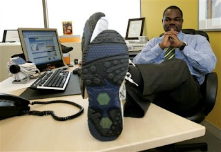 It's the latest implementation of satellite-based navigation into everyday life - technology that can be found in everything from cell phones that help keep kids away from sexual predators to fitness watches that track heart rate and distance.
GPS units are put into shoes because shoes aren't as easy to lose, unlike phones, watches and bracelets. The Quantum Satellite Technology promises to locate the wearer anywhere in the world with the press of a button
SHREK THE THIRD NEW TRAILER
Take a time-out from your work. The newest trailer for Shrek the Third is online. Enjoy!
Sunday, February 04, 2007
Google Earth agrees to blur pix of key Indian sites
 NEW DELHI: President APJ Abdul Kalam's concerns over Google Earth providing detailed and unhindered view of ‘sensitive' Indian establishments have been addressed, courtesy a formula which allows users uninterrupted access to the ‘eye in the sky' while camouflaging key installations.
Fuzzy, low resolution pictures and distorted building plans is how the government and Google Earth have agreed to get around concerns that images of sensitive military and scientific establishments available on the Web could either allow unauthorised snooping or become a ready reckoner for terrorists.
At a recent meeting between ministry of science and technology officials and Google Earth representatives, it was decided that installations identified by government would be carefully camouflaged. This, it was felt, was better than an outright blackout. Apart from well-known sites like BARC, there are many less prominent ones, and blacking them out would only attract attention to their locations.
Images of these locations will not be of more than 25-50 metre resolution, more like the older generation pictures provided by Indian Remote Sensing satellites. Official sources said Google Earth would distort building plans by adding structures where none existed or masking certain aspects of a facility. This could be done without attracting attention to such establishments, which range from laboratories, mines, military sites, space and atomic centres and residences of high-profile VVIPs.
The government list of such sites would be accepted by Google Earth. The controversy over Google Earth's images had gained momentum after Kalam, in October last year, expressed concern that unrestricted pictures on the web could have worrisome security implications. [via]
Saturday, February 03, 2007
The Beer Mapping Project

If you like beer and you like maps, then you may have found the right place.
beermapping.com is a project by someone who likes knowing exactly where he is and how far he needs to go for good beer. At this point, there is only one individual working on the Beer Mapping Project. But that one person has been supported by many friendly craft beer lovers who offer suggestions for new maps and they help by beta testing each map. Use the Contact Us link if you have something to say about the Beer Mapping Project, or if you think you could help out.
Beer Mapping Project is utilizing Google’s Mapping API that is offered free for anyone who is not making a profit or charging users to use the maps that are using it. Each location is pushed through a geocoder service (beermapping.com is now getting geocodes through Yahoo’s API) in order to get the latitude and longitude for the particular location. Sometimes these geocoders do not produce results that are exact. Leading to locations that are either slightly wrong, or really wrong. Because of this chance of error, please double check with the website of the location you wish to travel to. Do not take for granted that each location is mapped perfectly.
Abu Simbel Statues of Pharaoh Ramsses in 3D in Google Earth

The archaeological site of Abu Simbel in southern Egypt is home to the fabulous twin temples built during the era of Pharaoh Ramsses II which include four 20 meter statues of the Pharaoh. The temples and statues were carefully moved by antiquities experts 60 meters up the mountainside in the 1960s out of necessity due to the building of the Aswan Dam which formed Lake Nasser.
Read more about Abu Simbel at Wikipedia. One of the Google Earth Community members, 'pmaxfield2' recently posted a 3D model of the statues and temple. Check out the model in Google Earth 4. He even used photos of the statues and the new feature in SketchUp 6 (the free 3D modeling tool from Google) called Photo Match to add realistic textures to the model. Viewing this model in Google Earth gave me a new perspective on this site and encouraged me to learn more about it. Great work pmaxfield2!
Garmin to air TV commercial during Super Bowl XLI

Once again, GPS is going prime time.. this time with a featured spot in an ad during Super Bowl. Looks like location has been a pretty lucrative technology recently if this is any indication. Industry-heavyweight Garmin has scored big and will be airing a 30 second TV ad this week-end on superbowl Sunday.
The ad will feature Garmin Man and a Maposaurus! The theme of the commercial is "Grab your Garmin, Take on the World" – demonstrating how Garmin personal navigation devices can save the everyday consumer time, money, and hassles. Taken to the extreme, the commercial is a humorous 1960s-style sci-fi piece. The commercial's quirky low-tech production treatment is in playful contrast to Garmin's cutting edge GPS technology and other advertisers' use of complex computer effects. Catch the ad on Sunday. You can see some images of garmin man and maposaurus here.
Ads in Google Earth & Maps
 The Google Earth Blog has mentioned that ads in Google Maps & Earth have been updated from a random organization to a clearer, more defined ad that is focused more on the content of the search.
AAAS documents humanitarian crises with Google Earth

[Via Ogle Earth] What do Sudan, Lebanon and Zimbabwe have in common? Over the past two years, they have all had their respective humanitarian crises documented via satellite imagery. For Darfur in Sudan, a large number of recent high resolution images are now part of Google Earth's base layer, clearly showing refugee camps. For Lebanon and Zimbabwe, some individual images have been released, but turning them into KML overlays was left to the amateurs.
Until Now. Lars Bromley at the American Association for the Advancement of Science has just posted a much more complete set of annotated overlays for Lebanon and Zimbabwe, and also a timeline-enabled set of placemarks documenting attacks on civilians in Darfur during September-December 2006. The imagery of Zimbabwe and Lebanon is regions-enabled, properly aligned, and with impeccable sourcing. Lars says we should expect to see more of where this comes from.
I think it's great to see the fruits of scientific progress find such immediate, humanitarian uses. While it may not have been the case in the past, future leaders must now know that the humanitarian toll of their actions will be visible to all, archived, and pored over in minute detail when its time to write their histories.
Subscribe to:
Posts (Atom)