
Sunday, April 30, 2006
GIS Sites-Links for GIS Maps
Georgetown County GIS, South Carolina added.
GIS Sites-Links for GIS Maps
Thursday, April 27, 2006
Anson County NC GIS link.
I have added a link to Anson County GIS, North Carolina. It has full GIS with parcel search and payments options.
Senate Panel Recommends Abolishing FEMA
A new Senate bill proposed would call for the elimination of FEMA.
Click Here for Yahoo! News Article
Tuesday, April 25, 2006
NEW ADDITIONS
 Today, I have added 34 new GIS pages for the states section. I have also beefed up the world section with almost 20 new GIS pages of various sorts.
First, for the U.S.:
Auburn city GIS, AL; Anchorage, Alaska GIS; Little Rock City, Arkansas GIS; West Sacramento, California GIS; Hayward, Culver City, Azusa, Downy, Carson, and Laguna Beach City GIS, California; Fort Collins, Colorado GIS; Groton, Conn. GIS; Marietta City, Georgia, GIS; Linn County, Iowa GIS; Overland Park City, Kansas GIS; Kentucky Links-various, but include Campbell, Kenton, Boone, and Pendleton; Concord city, Mass. GIS; Meridian Township, MI GIS; Las Vegas, NV GIS; New Jersey Meadowlands Flood Incident GIS; New Windsor, NY GIS; Gaston County, Forsyth County, and Bladen County NC GIS; Pennsylvania and Texas Digital Atlas (Both GIS applications); Sioux City, SD GIS; Plano city, Denton County, and College Station GIS, TX; and Ogden City, UT GIS.
I had fun with the world GIS maps. I have included Maine Whale sightings and Lobster Tails, a sight to report and map Maine Lobsters around the world.
Also, the Baltic, Mediterranean, Black, and Caspian Seas GIS sites. Austria sites includes Linz, Austrian Federations, and Austrian Environment.
The UK has South Ayrshire GIS and Nottingham GIS. And there's also West and South Atlas of Australia, Sydney Australia GIS; Wroclaw, Poland; Israel; Iraq (which doesn't work all the time); Dubai (down, but will be up soon) and the Caribbean Sea.
Enjoy.
Today, I have added 34 new GIS pages for the states section. I have also beefed up the world section with almost 20 new GIS pages of various sorts.
First, for the U.S.:
Auburn city GIS, AL; Anchorage, Alaska GIS; Little Rock City, Arkansas GIS; West Sacramento, California GIS; Hayward, Culver City, Azusa, Downy, Carson, and Laguna Beach City GIS, California; Fort Collins, Colorado GIS; Groton, Conn. GIS; Marietta City, Georgia, GIS; Linn County, Iowa GIS; Overland Park City, Kansas GIS; Kentucky Links-various, but include Campbell, Kenton, Boone, and Pendleton; Concord city, Mass. GIS; Meridian Township, MI GIS; Las Vegas, NV GIS; New Jersey Meadowlands Flood Incident GIS; New Windsor, NY GIS; Gaston County, Forsyth County, and Bladen County NC GIS; Pennsylvania and Texas Digital Atlas (Both GIS applications); Sioux City, SD GIS; Plano city, Denton County, and College Station GIS, TX; and Ogden City, UT GIS.
I had fun with the world GIS maps. I have included Maine Whale sightings and Lobster Tails, a sight to report and map Maine Lobsters around the world.
Also, the Baltic, Mediterranean, Black, and Caspian Seas GIS sites. Austria sites includes Linz, Austrian Federations, and Austrian Environment.
The UK has South Ayrshire GIS and Nottingham GIS. And there's also West and South Atlas of Australia, Sydney Australia GIS; Wroclaw, Poland; Israel; Iraq (which doesn't work all the time); Dubai (down, but will be up soon) and the Caribbean Sea.
Enjoy.
FUN WITH GOOGLE MAPS-EUROPE!
Here are some Google Map finds from Europe.
Battle and cruise ship. In London, England.
Barcelona, Spain. This is a mesmerizing overhead view of an old city. The street layout and condensed housing make a neat pattern.
The Eiffel Tower, France.
Petronas Towers, Kuala Lumpur, Malaysia. Once the world's tallest buildings, these twin towers now fall short of the Taipei 101.
Vatican City.
Fernsehturm, Berlin, Germany Around 1,100 ft tall, this tower was used by the East German government when Berlin (and Germany) was divided into East and West. It once was used for TV and radio from the Communist Government of East Germany and is now a tourist spot with a cafe on the observation deck, about 650 ft up. It looks like an olive on a toothpick so be sure to check out the homepage to understand it's height. Pan to the left and look in the park to see the large, golden statue on the pedistal used in a lot of European films.
Link: Berlin Television Tower
Yahoo! Maps with Satellite images, Big $, and European Road now on Satellite Maps.

Yahoo! Maps now have Satellite Images.
In case you have missed it, Yahoo! Maps have slowly introduced satellite images into its new Beta version of maps. It's hard for the average person to discover the satellite images as Yahoo! doesn't really advertise it as of yet. But, go to Yahoo! Maps and click on the Beta version of maps. When Yahoo! puts some of their advertising weight behind it, Yahoo! Maps will easily rival Google Maps for easy use and quality. Google Maps has a simple button that allows for a quick link and for Yahoo! Maps you can just cut and paste the url for the coordinates.
Here's the Helena, MT test. I took satellite images of the capital in Helena, MT for you to compare on the different mapping engines. The reason I chose Helena is because it shows how far satellite mapping has come. It's easy to find Manhattan or L.A. satellite images, but to really map the world, a program must actually have useful and current images of places off the beaten path.
Yahoo! Maps: Helena, MT satellite image.
Google Maps: Helena, MT satellite image.
MSN Virtual Earth: Helena, MT satellite image.
As you can see by the comparison of the 3 images, Yahoo! is clear but doesn't come close to the zoom that Google has in this case. MSN is just outdated, being an image from the mid nineties and in B & W. On a personal note, I actually use MSN more than the others because even being outdated, they have more coverage across the U.S. than Google or Yahoo! But, that's changing with each passing month. But, now that it's become big business, the others are all catching up.

Online Mapping is Big Business.
Here's a quick link to a Forbes article about the boom in online satellite mapping. It goes into great detail about the new rivalry of the industry and how Yahoo! Maps actually beat out Google Maps recently in usage.
Click here for: Forbes Article.
Europe Road Names on Google Maps.
Google Maps has made a dramatic improvement to its service by adding European road names to its database. While it's not perfect or finalized, it is a start.
Click here for: Google Maps Europe.
Google Earth - Hi Res updates for Maldives and Europe.
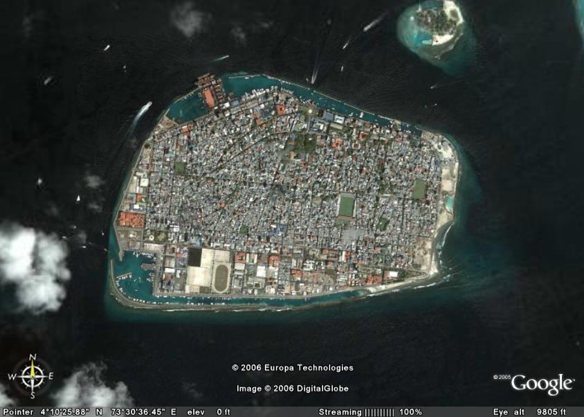 GoogleEarthBlog.com has created a link for the Google Earth update from late March. Included are new, hi-res files for the Maldives, among others, which allow the viewer to actually see airplanes flying over the ocean.
The satellite images of the Maldives are detailed enough to make out a giant sailboat and even strings of cabanas stretching out into the lagoons. If you've never had a chance to study up on the Maldives, Google Earth provides a good jumping point to see the chain of low level islands that are southwest of India. They are so low in elevation that almost all habitable land is occupied as seen in the picture above.
Follow the link from the Google Earth Blog to open the file in Google Earth. As long as you have Google Earth installed, it just takes one click and all the work is done for you. Don't worry about downloading or opening files. If you don't have Google Earth, then you missing out on a great virtual tour of the Earth that is continuously updated.
Click Here for: Google Earth.
Click Here for: Google Earth Blog
Click Here for: Maldives Hi-Res on Google Earth.
GoogleEarthBlog.com has created a link for the Google Earth update from late March. Included are new, hi-res files for the Maldives, among others, which allow the viewer to actually see airplanes flying over the ocean.
The satellite images of the Maldives are detailed enough to make out a giant sailboat and even strings of cabanas stretching out into the lagoons. If you've never had a chance to study up on the Maldives, Google Earth provides a good jumping point to see the chain of low level islands that are southwest of India. They are so low in elevation that almost all habitable land is occupied as seen in the picture above.
Follow the link from the Google Earth Blog to open the file in Google Earth. As long as you have Google Earth installed, it just takes one click and all the work is done for you. Don't worry about downloading or opening files. If you don't have Google Earth, then you missing out on a great virtual tour of the Earth that is continuously updated.
Click Here for: Google Earth.
Click Here for: Google Earth Blog
Click Here for: Maldives Hi-Res on Google Earth.
GasBuddy.com - Interactive Mapping of Gas Prices in North America.
 GasBuddy.com has gotten a bunch of interest lately as gas prices have soared through the roof. As Exxon pays out $400 million to its president and records high profits of over $9.9 Billion (Article here) , gas prices have forced many people in America to rethink their gas usage.

If you're having trouble keeping up with the daily price changes, then hop over to Gas Buddy where they have an updated map of the prices of gas throughout North America. Gas Buddy uses over 100 volunteer sites to keep up to date and also gives tips and polls to its viewers. Click here for GasBuddy.com
Monday, April 24, 2006
GIS sites added.
 It seems that most sites that I find lately are just assessor sites, but today I hit the jackpot with 13 more sites. All are GIS mapping sites, too.
For North Carolina:
Allegheny County GIS, NC; Blowing Rock County GIS, NC; Cleveland County GIS, NC; Davidson County GIS, NC; Rowan County GIS, NC; Surry County GIS, NC.
For Virginia:
Alleghany County GIS, VA; Bath County GIS, Va; Bedford city GIS, Va; Floyd County GIS, Va; Grayson County GIS, Va; Louisa County GIS, VA.
For West Virginia:
Summers County GIS, WV.
It seems that most sites that I find lately are just assessor sites, but today I hit the jackpot with 13 more sites. All are GIS mapping sites, too.
For North Carolina:
Allegheny County GIS, NC; Blowing Rock County GIS, NC; Cleveland County GIS, NC; Davidson County GIS, NC; Rowan County GIS, NC; Surry County GIS, NC.
For Virginia:
Alleghany County GIS, VA; Bath County GIS, Va; Bedford city GIS, Va; Floyd County GIS, Va; Grayson County GIS, Va; Louisa County GIS, VA.
For West Virginia:
Summers County GIS, WV.
P.S. BLOGGER is scheduled for an outage at 4PM PDT today. If there are problems, that will be the reason.
Blogger Website Problems.

I hope it hasn't been too much of a problem to access my website over the last few days. Blogger's had a small burp in their system and will be working more productive later this evening. Also, I have added tax maps and assessor data for West Bath, Maine.

Sunday, April 23, 2006
New Yellowpages Internet Mapping Program.
 Yellowpages.com is the newest kid on the block in the internet mapping world. Yellowpages have chosen MSN's VirtualEarth to map it's programs. More on this news from the following article:
Yellowpages to launch new mapping system
Saturday, April 22, 2006
Weekend Update - New sites added.
 New Maine Assessor sites added which include:
Augusta, ME Bar Harbor, ME Berwick, ME Boothbay, ME Camden, ME Cumberland, ME Eliot, ME Freeport, ME Gorham, ME Harpswell, ME Kittery, ME Old Orchard Beach, ME Raymond, ME Rockland, ME Rockport, ME Saco, ME South Portland, ME South Thomaston, ME Standish, ME Waterville, ME Wells, ME Westbrook, ME Yarmouth, ME York, ME
Massachusetts Sites, mostley assessor but a few with maps, include:
Abington, MA Amesbury, MA Amherst, MA Athol, MA Boston, MA Cambridge, MA Chatham, MA Chelmsford, MA Chelsea, MA Dartmouth, MA Dedham, MA Dracut, MA Dudley, MA Edgartown, MA Gardner, MA Georgetown, MA Harvard, MA Holden, MA Leominster, MA Lexington, MA Lowell, MA Mansfield, MA Marion, MA Marshfield, MA Medford, MA Middleboro, MA Millbury, MA Newburyport, MA North Attleboro, MA Oak Bluffs, MA Paxton, MA Quincy, MA Rowley, MA Rutland, MA Somerville, MA Southwick, MA Taunton, MA Templeton, MA Tisbury, MA Walpole, MA Wareham, MA Westfield, MA West Springfield, MA West Tisbury, MA Westwood, MA Woburn, MA Yarmouth, MA
New Hampshire Sites, all assessor, include:
Alton, NH Amherst, NH Bedford, NH Bow, NH Belmont, NH Candia, NH Concord, NH Dunbarton, NH Durham, NH Fitzwilliam, NH Epping, NH Fremont, NH Greenland, NH Henniker, NH Hinsdale, NH Hollis, NH Hooksett, NH Jaffrey, NH Laconia, NH Lebanon, NH Littleton, NH Moultonborough, NH Newbury, NH New Durham, NH New London, NH Newmarket, NH North Hampton, NH Pelham, NH Pembroke, NH Raymond, NH Rye, NH Salem, NH Sanbornton, NH Sandown, NH Sunapee, NH Swanzey, NH Tilton, NH Wolfeboro, NH
Rhode Island Assessor sites added which include:
Central Falls, RI Charlestown, RI Cranston, RI East Providence, RI Johnston, RI Little Compton, RI Middletown, RI Narragansett, RI Newport, RI New Shoreham, RI North Kingstown, RI North Smithfield, RI Portsmouth, RI Richmond, RI Smithfield, RI South Kingstown, RI Tiverton, RI Westerly, RI
New Maine Assessor sites added which include:
Augusta, ME Bar Harbor, ME Berwick, ME Boothbay, ME Camden, ME Cumberland, ME Eliot, ME Freeport, ME Gorham, ME Harpswell, ME Kittery, ME Old Orchard Beach, ME Raymond, ME Rockland, ME Rockport, ME Saco, ME South Portland, ME South Thomaston, ME Standish, ME Waterville, ME Wells, ME Westbrook, ME Yarmouth, ME York, ME
Massachusetts Sites, mostley assessor but a few with maps, include:
Abington, MA Amesbury, MA Amherst, MA Athol, MA Boston, MA Cambridge, MA Chatham, MA Chelmsford, MA Chelsea, MA Dartmouth, MA Dedham, MA Dracut, MA Dudley, MA Edgartown, MA Gardner, MA Georgetown, MA Harvard, MA Holden, MA Leominster, MA Lexington, MA Lowell, MA Mansfield, MA Marion, MA Marshfield, MA Medford, MA Middleboro, MA Millbury, MA Newburyport, MA North Attleboro, MA Oak Bluffs, MA Paxton, MA Quincy, MA Rowley, MA Rutland, MA Somerville, MA Southwick, MA Taunton, MA Templeton, MA Tisbury, MA Walpole, MA Wareham, MA Westfield, MA West Springfield, MA West Tisbury, MA Westwood, MA Woburn, MA Yarmouth, MA
New Hampshire Sites, all assessor, include:
Alton, NH Amherst, NH Bedford, NH Bow, NH Belmont, NH Candia, NH Concord, NH Dunbarton, NH Durham, NH Fitzwilliam, NH Epping, NH Fremont, NH Greenland, NH Henniker, NH Hinsdale, NH Hollis, NH Hooksett, NH Jaffrey, NH Laconia, NH Lebanon, NH Littleton, NH Moultonborough, NH Newbury, NH New Durham, NH New London, NH Newmarket, NH North Hampton, NH Pelham, NH Pembroke, NH Raymond, NH Rye, NH Salem, NH Sanbornton, NH Sandown, NH Sunapee, NH Swanzey, NH Tilton, NH Wolfeboro, NH
Rhode Island Assessor sites added which include:
Central Falls, RI Charlestown, RI Cranston, RI East Providence, RI Johnston, RI Little Compton, RI Middletown, RI Narragansett, RI Newport, RI New Shoreham, RI North Kingstown, RI North Smithfield, RI Portsmouth, RI Richmond, RI Smithfield, RI South Kingstown, RI Tiverton, RI Westerly, RI
Friday, April 21, 2006
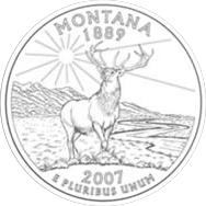
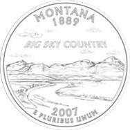
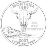
Vote of the New Montana Quarter Design.
Time is running out for the State of Montana to choose their individual design to grace the back of quarters in 2007 and you can be part of the process. Head over to http://governor.mt.gov/hottopics/mtquarters.asp to get the chance to vote on one of four designs. Personally, I go for the cow skull because it reminds me of the C.M. Russell paintings. Plus, it's a skull! How many states can say they have a skull on their quarter?
Links:
C.M. RUSSELL.ORG
MT.GOV QUARTERS

Thursday, April 20, 2006
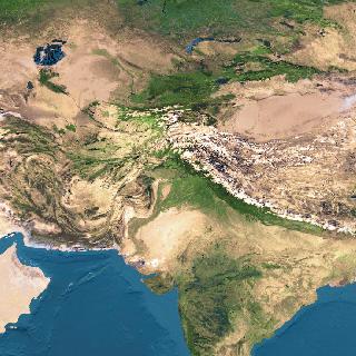
INDIA GIS AND CENSUS MAPS


Also, check out India from space with satellite images from http://www.liveindia.com/earth/2.html


Wednesday, April 19, 2006
FUN WITH GOOGLE MAPS- MAJOR LEAGUE BALLPARKS AL CENTRAL

Home of the 2005 World Series Champions, US Cellular Field is the new home to the White Sox after they moved there from the giant Comiskey Park, which housed the Sox for over 50 years. Old Comiskey saw some of baseball's most memorable moments during its day, including the 1919 'Black Sox' scandal and 1979's Disco Demolition Night.
 Disco Demolition Night
 Google map: CLEVELAND INDIANS, Jacob's Field
 Disco Demolition Night
 Google map: CLEVELAND INDIANS, Jacob's Field
Jacob's Field is a lush ballpark that opened in 1994. The previous Indian's field was Cleveland municipal Stadium which had all the appeal of a trainyard. The Indian's old digs can be seen in the movie 'Major League', which is Bob Uecker's finest role. In the movie, though, most of the interior scenes were shot using the old Milwaukee stadium, with all the exterior shots being from Cleveland's stadium.
 Major League
 Google map: DETROIT TIGERS, Comerica Park
Comerica Park is one of the newest parks in the AL for one of the oldest teams. Detroit is home to Ty Cobb, Sparky Anderson, Lou Whitaker, and Magnum P.I.
Google map: DETROIT TIGERS, Comerica Park
Comerica Park is one of the newest parks in the AL for one of the oldest teams. Detroit is home to Ty Cobb, Sparky Anderson, Lou Whitaker, and Magnum P.I.

 Google map: KANSAS CITY ROYALS, Kauffman Stadium
George Brett helped make Kauffman Stadium famous with his attempt to bat .400 in 1980. However, even with that, most people will remember the famous 'Pine-tar' game in which Brett charged the ump in a critical game after his homerun was taken away for an illegal bat.
The Royals were also home to one of the best 2 sport players in Bo Jackson.
Google map: KANSAS CITY ROYALS, Kauffman Stadium
George Brett helped make Kauffman Stadium famous with his attempt to bat .400 in 1980. However, even with that, most people will remember the famous 'Pine-tar' game in which Brett charged the ump in a critical game after his homerun was taken away for an illegal bat.
The Royals were also home to one of the best 2 sport players in Bo Jackson.


Major League
 Google map: DETROIT TIGERS, Comerica Park
Comerica Park is one of the newest parks in the AL for one of the oldest teams. Detroit is home to Ty Cobb, Sparky Anderson, Lou Whitaker, and Magnum P.I.
Google map: DETROIT TIGERS, Comerica Park
Comerica Park is one of the newest parks in the AL for one of the oldest teams. Detroit is home to Ty Cobb, Sparky Anderson, Lou Whitaker, and Magnum P.I.

 Google map: KANSAS CITY ROYALS, Kauffman Stadium
George Brett helped make Kauffman Stadium famous with his attempt to bat .400 in 1980. However, even with that, most people will remember the famous 'Pine-tar' game in which Brett charged the ump in a critical game after his homerun was taken away for an illegal bat.
The Royals were also home to one of the best 2 sport players in Bo Jackson.
Google map: KANSAS CITY ROYALS, Kauffman Stadium
George Brett helped make Kauffman Stadium famous with his attempt to bat .400 in 1980. However, even with that, most people will remember the famous 'Pine-tar' game in which Brett charged the ump in a critical game after his homerun was taken away for an illegal bat.
The Royals were also home to one of the best 2 sport players in Bo Jackson.


 Google map: MINNESOTA TWINS, Hubert H. Humphrey Metrodome
The Twin's were home to the late, great Kirby Puckett who passed away this year. During his time on the field, the Twin's visited the World Series and gave the Metrodome plenty of TV exposure. Remember the Hefty Bag-looking outfield walls? Yuck!
Google map: MINNESOTA TWINS, Hubert H. Humphrey Metrodome
The Twin's were home to the late, great Kirby Puckett who passed away this year. During his time on the field, the Twin's visited the World Series and gave the Metrodome plenty of TV exposure. Remember the Hefty Bag-looking outfield walls? Yuck!

Tuesday, April 18, 2006
Fun with Google Maps - Major League Baseball Stadiums.
Baseball is here and there's no better excuse to play with Google Maps then to check out the stadiums of the Major League teams. We'll begin with the AL West and look at satellite images of the ballparks.. Make sure to click on the underlined team name to view the satellite image of the ballpark.

The Angels have changed their name again this year, making it hard to figure out how many cities they're putting on their uniform. They stuck the 'Los Angeles' back in the name after being 'California' and 'Anaheim' over the last few years. If you pan to the northwest, you can look in on Disneyland. Angels Stadium is an old dual use field that used to house the Los Angeles Rams. After the Rams left for St. Louis, the stadium got a facelift to make it more Baseball friendly.
 Google Map: OAKLAND ATHLETICS, McAfee Coliseum
Not exactly the nicest stadium to look at, McAfee is a dual use stadium that still houses the Oakland Raiders during the fall. Just like Anaheim Stadium, McAfee opened back in 1966. During the years, the A's have seen some strong teams, including McGwire & Canseco.
 Google map of: SEATTLE MARINERS, SAFECO FIELD.
Google map of: SEATTLE MARINERS, SAFECO FIELD.
Opened in July 1999, Safeco Field is a retractable roof stadium just south of the new Seahawks Stadium. Make sure to zoom in and watch the WSU football game going on at Seahawks Stadium directly to the north of Safeco Field.
 TEXAS RANGERS, Ameriquest Field in Arlington
 TEXAS RANGERS, Ameriquest Field in Arlington
Opened April 1, 1994, Ameriquest Field has all the perky characteristics of Ebbets field mixed with the pillars of old Detroit Tigers Stadium. The Rangers were owned by George W. Bush before he was governor of Texas.
Also, check out Ballparks.com for more info.
Great new site for U.S. State Facts and Figures
 StateMaster.com is more than just a rehash of census data. They have grouped the information wisely and added comparison features and quick maps and graphs. The site is quick to load and easy to use.
Here's a description from their own site:
"Welcome to StateMaster.com, a unique statistical database which allows you to research and compare a multitude of different data on US states."
Where StateMaster.com excels is the ability to quickly access data and view it in a variety of graphs, maps, and charts. I only wish I had this site when I was writing my final papers. The website is well managed and easy to use. Their stats are well researched and in detail. They have everything from death rates to how 4th and 5th graders did in math.
A ticker sits on the top of the website and spouts interesting facts from their files. Make sure to click on it to find more info. Overall, a vital source of information and facts with a quick and easy to use website.
Site: StateMaster.com
StateMaster.com is more than just a rehash of census data. They have grouped the information wisely and added comparison features and quick maps and graphs. The site is quick to load and easy to use.
Here's a description from their own site:
"Welcome to StateMaster.com, a unique statistical database which allows you to research and compare a multitude of different data on US states."
Where StateMaster.com excels is the ability to quickly access data and view it in a variety of graphs, maps, and charts. I only wish I had this site when I was writing my final papers. The website is well managed and easy to use. Their stats are well researched and in detail. They have everything from death rates to how 4th and 5th graders did in math.
A ticker sits on the top of the website and spouts interesting facts from their files. Make sure to click on it to find more info. Overall, a vital source of information and facts with a quick and easy to use website.
Site: StateMaster.com
Monday, April 17, 2006
U.S. Weather Satellite Moved Over Amazon River.
 U.S. meteorologists are finding a new use for hurricane satellites during the offseason. They will move the satellite to areas with more pressing needs.
From article:
U.S. meteorologists are finding a new use for hurricane satellites during the offseason. They will move the satellite to areas with more pressing needs.
From article:
In October, the U.S. National Oceanic and Atmospheric Administration plans to reposition an aging but reliable 9-year-old satellite high over the Brazilian Amazon to provide full-time coverage for forecasters who now weather long periods without regular images during U.S. hurricane season.
US Satellite Article
Google Map of Amazon
Also, the Japanese Aerospace Exploration Agency (JAXA) regularly updates its site of climate and satellite images. First to note is their Global Navigator, an interactive map of the world with highlighted points of interest. Then, on their main site, are archived data sets and articles on everything from hurricanes to La Nina. There are some great articles for research to be found here.
Friday, April 14, 2006
Beautiful China - Pictures of China
 Take a tour of mainland China courtesy of FunMansion.com. The terraced landscapes and chiseled topography are sure to amaze you. Also, add in some beautiful sunsets and early morning mists for good measure. The rich photography captures the beauty of China.

 Click here for more pictures of China
Thursday, April 13, 2006
Online Atlas
 Merriam-Webster's Online Atlas is a good bookmark for anyone needing a quick reference to information on Singapore, or whatever country you need stats for in a hurry. The references are limited when compared to the CIA World Factbook, but is good for presentations or quick facts.
Wednesday, April 12, 2006
Virtual Tour of 1906 San Francisco Earthquake.
 Thanks to the power of Google Earth, one can now re-create the infamous 1906 earthquake that ripped up and shaped San Francisco, California. The USGS has enlisted Google Earth to utilized the ability to download and manipulate files (known as kml.files) and create a virtual tour of the site with multiple layers. A similar use of Google Earth in manipulated form was illustrated with Maxim Magazine's 100th Issue cover of Eva Longoria being a 100' banner in the middle of Nevada and seen on Google Earth (Previous Post).
Google Earth continues to show its potential and growth as a useful tool with multiple applications. One can only imagine the future uses of Google Earth.
Link: Virtual Tour of 1906 San Francisco Earthquake.
Thanks to the power of Google Earth, one can now re-create the infamous 1906 earthquake that ripped up and shaped San Francisco, California. The USGS has enlisted Google Earth to utilized the ability to download and manipulate files (known as kml.files) and create a virtual tour of the site with multiple layers. A similar use of Google Earth in manipulated form was illustrated with Maxim Magazine's 100th Issue cover of Eva Longoria being a 100' banner in the middle of Nevada and seen on Google Earth (Previous Post).
Google Earth continues to show its potential and growth as a useful tool with multiple applications. One can only imagine the future uses of Google Earth.
Link: Virtual Tour of 1906 San Francisco Earthquake.
Tuesday, April 11, 2006
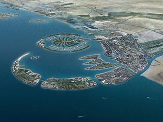
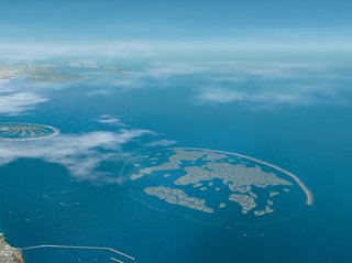
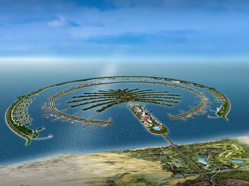
Welcome to Your New Home- The Palm, Dubai.
The islands are almost complete, and if you are rich then you can own a piece of history. Man made islands are being constructed in the shapes of palm trees, among other things, in the Middle East. Come to Dubai and live on a replica of the world or a palm tree.
The Palm
Developments


Saturday, April 08, 2006
Eva Longoria Maxim Cover on Google Earth.
 Who knew that Google Earth could be used to broadcast a 100 foot picture of 'Desparate Houswives' star Eva Longoria for satellites to see. Thanks to Maxim Magazine and their 100th issue, people with Google Earth, and traveling aliens, can catch a glimpse of the cover. It turns out that to help celebrate the 100th issue of Maxim Magazine, the company made a vinyl replica in the desert outside Las Vegas, NV.
The image is actually 75' x 110' and can be viewed by linking to Maxim Magazine here.
Also, the direct link location for the Kml file is here.
Who knew that Google Earth could be used to broadcast a 100 foot picture of 'Desparate Houswives' star Eva Longoria for satellites to see. Thanks to Maxim Magazine and their 100th issue, people with Google Earth, and traveling aliens, can catch a glimpse of the cover. It turns out that to help celebrate the 100th issue of Maxim Magazine, the company made a vinyl replica in the desert outside Las Vegas, NV.
The image is actually 75' x 110' and can be viewed by linking to Maxim Magazine here.
Also, the direct link location for the Kml file is here.
Subscribe to:
Posts (Atom)