 GoogleEarthBlog.com has created a link for the Google Earth update from late March. Included are new, hi-res files for the Maldives, among others, which allow the viewer to actually see airplanes flying over the ocean.
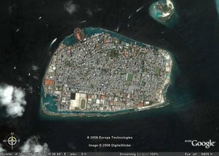
The satellite images of the Maldives are detailed enough to make out a giant sailboat and even strings of cabanas stretching out into the lagoons. If you've never had a chance to study up on the Maldives, Google Earth provides a good jumping point to see the chain of low level islands that are southwest of India. They are so low in elevation that almost all habitable land is occupied as seen in the picture above.
Follow the link from the Google Earth Blog to open the file in Google Earth. As long as you have Google Earth installed, it just takes one click and all the work is done for you. Don't worry about downloading or opening files. If you don't have Google Earth, then you missing out on a great virtual tour of the Earth that is continuously updated.
Click Here for: Google Earth.
Click Here for: Google Earth Blog
Click Here for: Maldives Hi-Res on Google Earth.
Tuesday, April 25, 2006
Google Earth - Hi Res updates for Maldives and Europe.
 GoogleEarthBlog.com has created a link for the Google Earth update from late March. Included are new, hi-res files for the Maldives, among others, which allow the viewer to actually see airplanes flying over the ocean.
The satellite images of the Maldives are detailed enough to make out a giant sailboat and even strings of cabanas stretching out into the lagoons. If you've never had a chance to study up on the Maldives, Google Earth provides a good jumping point to see the chain of low level islands that are southwest of India. They are so low in elevation that almost all habitable land is occupied as seen in the picture above.
Follow the link from the Google Earth Blog to open the file in Google Earth. As long as you have Google Earth installed, it just takes one click and all the work is done for you. Don't worry about downloading or opening files. If you don't have Google Earth, then you missing out on a great virtual tour of the Earth that is continuously updated.
Click Here for: Google Earth.
Click Here for: Google Earth Blog
Click Here for: Maldives Hi-Res on Google Earth.
Subscribe to:
Post Comments (Atom)
No comments:
Post a Comment