CALCULATE YOUR ECOLOGICAL FOOTPRINT

Thursday, November 30, 2006 | | 2 comments |

Ever wondered how much "nature" your lifestyle requires? You're about to find out. This Ecological Footprint Quiz estimates how much productive land and water you need to support what you use and what you discard.

After answering 15 easy questions you'll be able to compare your Ecological Footprint to what other people use and to what is available on this planet.

CALCULATE YOUR ECOLOGICAL FOOTPRINT

ALABAMA GIS LINKS

Wednesday, November 29, 2006 | | 0 comments |

GIS PILOT links for ALABAMA GIS sites:

MAPS OF THE WORLD

Monday, November 27, 2006 | | 0 comments |

If you are in the need for a map from anywhere in the world then take a look at NATIONS ONLINE. Every country is represented with various projections and download links for easy use.

They do not have an extensive library like the University of Texas map room, which is by far the best, but the availability of links is a great starting point. The U of Texas map room has a huge selection of down loadable maps from everywhere in the world. Their backlog of maps is just insanely huge.

VIRGINIA GIS LINKS

| | 0 comments |

GIS PILOT GIS links for Virginia

,,

GIS PILOT SITE UPDATE

Sunday, November 26, 2006 | | 0 comments |

GIS PILOT gets a visual update with new graphics and tables. The layout is the same and all the links are still available. There are still almost 2,000 GIS LINKS broken down by state and country. GIS LINKS are quickly located on the table and lead to individual pages for each section of links.

GIS LINKS & GIS PILOT

Friday, November 24, 2006 | | 0 comments |

I changed the format of this blog a few weeks back and transferred all the GIS links from here to my main site at GIS PILOT. There are still GIS LINKS on the right hand column of this site and they will direct you to the respective site on GIS PILOT. This was mandatory because by keeping all the links directly on this Blogger site, it was running very slow and it had many errors. Blogger's great for many things, but hosting huge HTML files is not one of them. So, randomly, I will post some links in the posts to remind people that they can still get their GIS mapping links here.

Cartographical Map Projections

Thursday, November 23, 2006 | | 0 comments |

One important concern of cartography is solving how to project, i.e. transform or map points from an almost spherical lump of rock (our Earth) onto either flat sheets of paper or not-so flat phosphorus-coated glass. Find out all you need to know about Map Projections from Cartographical Map Projections.

MAPS!

| | 0 comments |

A great collection of ancient maps. Be warned, though. The gallery is very large and will take a minute to load. But, the end results are worth it. File through over 250 maps. Ancient Map Collection

STATE CAPITAL QUIZ

| | 0 comments |

Pressure situation! It's only the lower 48 states, so that should give you an edge. The purpose is to get the correct location of the capital in a good time.

HAWAII Earthquake again

| | 0 comments |

For the second time in over a month, an earthquake has rattled the island of Hawaii. On October 15, a 6.7 magnitude quake hit the area. Today's is labled around a 4.5 to 5.0 . No Tsunami is reported to be expected from the quake

,, ,

Geography gets a new island

| | 0 comments |

According to various unsubstantiated reports by eyewitnesses, it would appear that the 169 islands of Tonga is gaining island number 170. Developing from an undersea volcano, the new island is located between the islands of Kao in the Ha'apai Group and Late in the Vava'u Group. The Matangi Tonga news source has all the latest details.

Thanks to Matt for the article.

50 state capitals in 50 consecutive days

Wednesday, November 22, 2006 | | 0 comments |

Since I last posted on these 2 guys hitchhiking across the US to see all 50 capitals in 50 days, they've made a lot of headway and started to drum up a little publicity for both themselves and this site.

I was lucky enough to have my post mentioned on the guys in a couple of blogs. Hopefully, there were a few extra rides comin' the guys way to make their journey a little easier. As of this post, they are in Arizona getting near the end. Hawaii is the trick. Find out how they do it at Hitch50.

Check out the mentions in MSNBC.com and ATTU's WORLD!

Blog, Tech, Internet, technology, Art, Humor, Entertainment, Media, Fun, Funny, Travel, Gps,Geography, blogger, Google Maps, scotty, basset hounds, fiddy,hitchhike,hitch50

Renewable Energy Atlas of the West

| | 0 comments |

The Renewable Energy Atlas of the West is designed as a resource for policy makers, advocates, landowners, developers and others interested in furthering the production of electricity from renewable wind, solar, geothermal and biomass energy resources.
Renewable Energy Atlas of the West

James Niehues

| | 0 comments |

James Niehues hand paints and airbrushes each large format watercolor original to best capture the detail and variations of each view's natural beauty and definition.

Jim has been painting aerial views since 1986 and has completed over 200 illustrations for resorts, tourist bureaus, and chambers of commerce. His images are used in brochures, web sites, ads, maps, posters, art prints, signage, post cards and retail items.

First Daughter Barbara Bush Robbed in Argentina

Tuesday, November 21, 2006 | | 0 comments |

It's not been a good few days for members of the Bush presidency. First, a motorcyle accident in Hawaii created havoc in a motorcade, followed by a staffer getting beaten up, then the Bush daughter, Barbara, gets mugged in Argentina.
  • First Daughter Barbara Robbed in Argentina - First Daughter Barbara Bush had her purse and cell phone stolen as she had dinner in a restaurant in Buenos Aires, Argentina, even though she was being guarded by a detail of Secret Service agents, according to law enforcement reports made available to ABC News. [...article...]
  • Two injured motorcycle officers in serious condition -Two of the three Honolulu Police Department motorcycle officers involved in a crash while escorting President George W. Bush to Hickam Air Force Base are in serious condition at The Queen's Medical Center. The motorcycles reportedly slipped indvidually on a rain-slicked roadway at about 7:10 a.m near the base entry area . [...article...]
  • White House Staffer Robbed, Beaten In Waikiki - The acting director of the White House Travel Office was robbed and beaten in Waikiki early on Tuesday morning outside a nightclub, according to Honolulu police. Pitts' passport and international phone were also taken. [...article...]
  • U.S. to Require Passports for Nearly All - Nearly all air travelers entering the U.S. will be required to show passports beginning Jan. 23, including returning Americans and people from Canada and other nations in the Western Hemisphere. The date was disclosed Tuesday by Homeland Security Secretary Michael Chertoff in an interview with The Associated Press. The Homeland Security Department plans to announce the change on Wednesday. [...article...]
  • TEEN GOES NUCLEAR: He creates fusion in his home (Nothing to do with Gov't, but just downright cool!) - He first achieved fusion in September and has been perfecting the machine he built in his parents' garage ever since. This year, Thiago was a semifinalist for the Siemens Foundation's National Research Competition. He plans to enter the Science and Engineering Fair of Metropolitan Detroit, which is in March, in hopes of qualifying to be in the Intel International Science and Engineering Fair in New Mexico in May. [...article...]

World Flag / Geography Test

| | 0 comments |

Normally, I can take the map tests and get by without looking like a fool. Then I found the Flag test which takes it one step up and gives you clues on the geography to guess the nations flag. Sounds easy enough, but hit up some of the small Asian or Former Soviet Republic nations and then see how much you know.

United States Map Quiz

| | 0 comments |

Another Map quiz. Try to place the states in their correct place.

United States Map Quiz

Virtual Earth 3D beta: A new dimension for mapping and Live Search

| | 0 comments |

What if mapping the world was more like a video game?

What if you could fly like Superman and figure out where to meet your friends for a good meal and which routes to avoid to beat traffic?

With Live Search maps you can find yellow pages and white pages information, get live traffic conditions and view stunning 3D and Birds Eye …just as if you were gaming in Second Life, but with real-world information embedded in real-world cities where advertising really matters?

Check out our beta for Virtual Earth™ 3D , a new online mapping feature launched this week by Live Search. You can see terrain information for all over the world, and explore these U.S. urban areas with textured buildings (with many more to come in the next month!): San Francisco, San Jose, Seattle, Boston, Philadelphia, Los Angeles, Las Vegas, Detroit, Phoenix, Houston, Baltimore, Atlanta, Denver, Dallas and Fort Worth. There is a virtual tour that you can review before diving into the goodness.

While many folks will opt to use their keyboards, you can even use an Xbox controller to navigate the three-dimensional world for greater deftness and speed.

In addition, developers can use the Virtual Earth 3D application programming interface to build these search capabilities into their own applications and Web sites. This and other APIs for Live Search are open to developers, with the option to acquire additional support and other benefits through a service-level agreement with Microsoft. Developers can find more information about the Virtual Earth API at http://dev.live.com/virtualearth and in the Virtual Earth SDK http://dev.live.com/virtualearth/sdk/. Also, contact maplic@microsoft.com for details about additional support.

Some folks in the blogosphere noticed and we appreciate it: Liveside.net , TechCrunch, Brady Forrest , Robert Scoble, Search Engine Journal to name a few. Keep talking about it and also, let us know how to improve. As with any beta product we’d love to have feedback. You can let us know on the Virtual Earth blog at http://virtualearth.spaces.live.com/, where product updates are posted continually, or use the handy feedback link at the bottom of the application.

--The Spaceland team

Source Article

Mapping race for ocean riches underway

| | 0 comments |

NOVA SCOTIA (CBC) - Canada is trying to chart new territory off the East Coast and in the Arctic to claim the resources below, but the right to stake that claim has turned into a race against the clock. The Canadian Coast Guard icebreaker Louis St. Laurent has spent four months in the Arctic laying plotting points on the outer edge of the continental shelf, an underwater mountainside that slopes as deep as 3,000 metres under the sea and ice.

"Once the edge is defined and that data is submitted to the United Nations, once that's approved, then that's Canada's territory," said Capt. Andrew MacNeil.

Dick MacDougall, with the Hydrographic Service of Canada, the agency that makes ocean maps, says the area in the East Coast is a million square kilometres, while the area in the Arctic is about 750,000 square kilometres.

"It's roughly the size of the three prairie provinces, to which Canada would have the rights to the sea bed, the resources on the sea bed and the resources below the sea bed," said MacDougall.

Finding the edge of the shelf and measuring the land that extends from it can be blocked by rocks and sediment on the bottom. To get that proportion right, mappers must look at where the sediment starts to thin out.

...continue article

ANGRY BEAVER SHIRTS

Monday, November 20, 2006 | | 0 comments |

Dam It All! Catch the Angry Beaver as he looks out on the world and wants to conquer it the only way he knows how - by building dams! Dark Tees, Light Tees, Thongs (Yeah! I went there!), Bags, cards, stickers, and gifts. Nice!

BLUE PLANET - PHOTO ESSAY

Sunday, November 19, 2006 | | 0 comments |

What a Beautiful Blue Planet is a series of satellite pictures of the Earth with the goal to help people realize what a nice home we all have.

What a Beautiful Blue Planet

Directions Magazine

| | 0 comments |

The Worldwide Source for Geospatial Technology

Directions Magazine was first published in 1998 and remains the premier news and resource guide for geospatial professionals.

Directions Magazine publishes weekly newsletters about geographic information systems, global positioning systems, desktop mapping, cartography, computer-aided design, remote sensing, web services, and more.

Directions Magazine

NFL BLACKOUT MAPS

Saturday, November 18, 2006 | | 0 comments |

Have you ever wondered what the heck the programmers were thinking when they set up the games in your local market. In East Tennessee, they have a simple formula: pick the lamest game. This market is exempt from the rest of the country, however, as indicated in the NFL Blackout Maps which show the local programming for each area of the country.

NFL BLACKOUT MAPS

CountryReports.org — Country Information

| | 0 comments |

CountryReports.org — Country Information

CountryReports.org was established in 1997 out of a love for international relations and culture. Entirely web-based, we offer more than 26,000 pages of content covering a wide-range of topics. Our statistical data and cultural information has proven to be valuable to students, parents, teachers, and researchers alike. In a sea of competing websites, CountryReports.org stands out as a leader, ...:

CountryReports.org — Country Information

CITY-DATA.COM

| | 0 comments |

CITY-DATA.COM

We've collected and analyzed data from numerous sources to create as complete and interesting profiles of all U.S. cities as we could. We have over 30,000 city photos not found anywhere else, hundreds of thousands of maps, satellite photos, stats about residents (race, income, ancestries, education, employment...), geographical data, state profiles, crime data, housing, businesses, birthplaces of famous people, political contributions, city government employment, weather, hospitals, schools, libraries, houses, airports, radio and TV stations, zip codes, area codes, user-submitted facts, similar cities list, comparisons to averages... If you ever need to research any city for any reason, from considering a move there to just checking where somebody you know is staying, this is the site for you.

CITY-DATA.COM

Multimap.com – Online Maps to Everywhere

| | 0 comments |

www.multimap.com is Europe’s most popular mapping web site, offering a range of free, useful services to assist with everyday life. Key features include street-level maps of the United Kingdom, Europe, Australia, New Zealand, Canada, the US and a number of cities worldwide; road maps of the world; door-to-door travel directions; aerial photographs with map overlay; and local information. Multimap also provides a range of complementary services through its partners. These include hotel, holiday-cottage, and restaurant-booking services, and the ability to buy both historic and aerial photograph prints.

Since its launch in 1996, Multimap has become one of the 10 most-visited sites in the UK. The consumer web site regularly receives more than 12 million unique users and delivers more than 190 million page views per month. Traffic continues to grow on average by 30% annually.

Multimap.com – Online Maps to Everywhere

GPS Surveillance Creeps into Daily Life

Friday, November 17, 2006 | | 0 comments |

For $5.99 per month, you can turn a cell phone into a surveillance device and track when your target leaves home, where he or she travels and at what speed. You can even detect how much battery power is left on the phone. Marketed as "virtual eyes" on your kids or employees, the service also allows you to construct a virtual "fence" so that you can receive electronic alerts if the phone’s carrier crosses into forbidden areas.

...Florida GIS Data Blog

World's Highest Resolution Commercial Satellite

| | 0 comments |

GeoEye-1, World's Highest Resolution Commercial Satellite, Will Use SGI Technology to Process Image Data

Billion of Bytes Sized Data Sets for National Security and Commercial Applications Demand 64-Bit, High-Performance Compute Only SGI Altix Systems Can Deliver

ORLANDO, Fla., GEOINT 2006, Booth 207, (November 15, 2006) — In anticipation of the spring 2007 launch of an extremely high-resolution Earth imagery satellite, GeoEye (Nasdaq:GEOY), the world's largest commercial satellite remote-sensing company, purchased high-bandwidth, high-performance compute technology from SGI (Nasdaq: SGIC). At the Dulles, VA, ground station for the new GeoEye-1 satellite, four SGI® Altix® systems were delivered during the first calendar quarter that will drive core satellite image processing for the .41-meter panchromatic (sensitive to all visible colors) and 1.65-meter multi-spectral (sensing and recording radiation from invisible as well as visible parts of the electromagnetic spectrum) imagery. GeoEye-1 is anticipated to collect more than 700,000 square kilometers - billions of bytes - of high-resolution imagery every day. A long-time SGI customer supplying imagery to the U.S. government, international governments and a growing number of commercial clients, GeoEye selected SGI systems because the record amounts of image data from the new satellite will require 4X the processing power.

"We have three satellites currently in orbit - OrbView-2 and 3, and IKONOS - but when GeoEye-1 becomes fully operational, it will be the world's most powerful and most accurate high-resolution commercial imaging satellite. It's going to collect more imagery on a given day than any commercial system currently on orbit," said Don Koboldt, senior principal geodetic engineer, GeoEye. "I chose SGI Altix because it has 64-bit processing power, not 32, and because there's a lot of computing power required for everything we do, including modeling the sensor and re-sampling all this data onto a geographic system. Not to mention the actual volumes of pixel data that has to be processed. It's both an I/O-bound problem and a compute problem, and SGI is taking the lead in designing systems for this need."

The GeoEye-1 satellite's ability to go down to a .41-meter resolution means, in simple terms, the high-resolution imagery taken from orbit and processed by the SGI® Altix® 350 systems will be capable of discerning objects on the ground 16 inches in size or larger. At that resolution, one would be able to identify home plate on a baseball diamond or count the manholes on a city street. In general, GeoEye's products are utilized in a wide variety of applications including defense and intelligence for large area mapping, state and local governments for urban planning and mapping, insurance and risk management, environmental monitoring and disaster relief. Such imagery is also ideal for on-line mapping search engines.

...More at GeoEye Press Release

Drought Monitor Interactive Maps

| | 0 comments |

The Drought Impact Reporter is an interactive tool developed by the NDMC to collect, quantify, and map reported drought impacts for the United States. The tool was created in response to the need for a national drought impact database. Information for the impact report database comes from a variety of sources, including on-line drought-related news stories and scientific publications, reviewed by NDMC staff; members of the public who visit the website and submit a drought-related impact; members of the media; and members of government agencies such as NOAA and USDA.

MAP TEST-How good are You?

Thursday, November 16, 2006 | | 0 comments |

It's a little harder than it looks because they throw in a bunch of "...stans" that I had trouble with.

Tsunamis slap Hawaii, Calif. north coast

| | 0 comments |

By AUDREY McAVOY, Associated Press Writer

HONOLULU - Tsunamis generated by a major earthquake near Japan left behind little damage but offered a legitimate test of international warning systems.

The waves, some measuring a few feet high, struck Hawaii shores Wednesday, slightly injuring one swimmer and temporarily flooding a harbor. A surge along California's northern coast destroyed two docks in Crescent City Harbor and damaged a third.

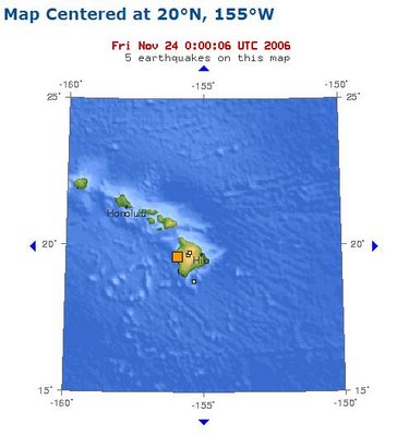
The waves hit Hawaii about six hours after a magnitude 8.1 earthquake struck north of Japan. Tsunami warnings were issued by the Pacific Tsunami Warning Center, which reported that its system of sending alerts functioned properly.

"It went very smoothly, and there weren't any major problems at all," said Brian Shiro, a geophysicist at the center. "We issued a warning for 1,000 kilometers surrounding the earthquake and an advisory for the rest of the Pacific Ocean."

The alerts were canceled once the center received further information that showed the tsunami was going to be small, he said. The center canceled the tsunami watch for Hawaii when it became clear the waves were unlikely to top one meter, or about 3.3 feet.

But local civil defense authorities still warned people to stay out of the water and to exercise caution near harbors, given the possibility the earthquake would generate unusual currents around Hawaii.

A woman swimming at Waikiki suffered cuts when she was sucked through an opening in a seawall as the water receded just before the swells arrived. She was otherwise fine, said John Cummings, a spokesman for Oahu Civil Defense.

On Kauai, a 2 1/2-foot swell flooded a parking lot at Nawiliwili Harbor. No serious damage was reported.

"Some of the boats hit the bottom with their keels when the water receded, sort of jostled them around their moorings when the wave came through," said Mark Marshall, Kauai County civil defense administrator.

In California, the weather service issued an early-morning tsunami advisory but dropped it by the time waves traveling up to 30 mph moved in at Crescent City, about 20 miles south of the Oregon state line.

Harbor workers there noticed a fast-moving current around mid-afternoon that harbor master Richard Young described as a "river within the ocean."

As the surge rushed out of the harbor, two floating docks in the inner basin were destroyed, Young said. Another surge followed, severely damaging a third dock, he said.

Several vessels attached to the destroyed docks bobbed away from their anchorage and likely received dings and possibly greater damages, the harbor master said.

Young said the replacement costs of the docks could range from $300,000 to $700,000.

Some 400 miles to the south, waves pounded the Santa Cruz yacht harbor all afternoon, causing several boats to break away from their moorings and capsizing a small sailboat.

"It wasn't wave action," said Dave Reynolds, a Monterey-based weather service meteorologist. "It was the current that caused the damage. This is almost like a fast-moving river of water that is coming in, so ... it's the currents that toss the boats around."

Thousands of people living along northern Japan's Pacific coast fled to higher ground, but Japan's meteorological agency withdrew its tsunami warning after about three hours. The waves near Japan did not swell higher than 23 inches.

___ On the Net:

Pacific Tsunami Warning Center

Source Article

ATTENTION-NEW FORMAT-PLEASE READ

| | 0 comments |

Welcome to the new format for GIS SITES the blog companion to my GIS & Mapping link site, GIS PILOT. As of today, there is a new format for this site which STILL INCLUDES all GIS LINKS from the old format. All the GIS LINKS are now on the sidebar to the right. Because the links are similar to GIS PILOT, my main site, and it is a hassle to update links on 2 sites, only GIS PILOT will have updated links from now on. This blog will always have GIS LINKS on it, just now it will be smaller and load faster.

All links for GIS SITES for the states and countries will point toward their respective GIS PILOT links. This allows for an easier management for the blog and GIS PILOT. Blogger has problems with the size of the HTML for this BLOG, resulting in just painfully slow load times and publishing with many errors. Both sites will remain active and doing their same jobs. I'm only condensing this blog for easier management.
Thanks

World Sunlight Map

| | 0 comments |

Watch the sun rise and set all over the world on this real-time, computer-generated illustration of the earth's patterns of sunlight, darkness, and cloud cover based on current weather satellite data.

BREATHING EARTH

| | 0 comments |

The BREATHING EARTH is a simulation of birth and death with a touch of pollution added in. As it runs, the births and deaths are recorded along with CO2 emissions from around the world. Thanks to Dave and Thomas for the link to BREATHING EARTH.

Map of Earthquake that prompted tsunami warnings in Japan

Wednesday, November 15, 2006 | | 0 comments |

A powerful undersea earthquake prompted tsunami warnings Wednesday for Japan and Russia but the danger appeared to pass after a series of tiny waves hit the northern Japanese coast.

The waves did not swell higher than 16 inches and rapidly diminished in size, but Japan's meteorological agency said that it would wait for at least several hours before withdrawing its warning of possible larger waves.

Customers are beginning to receive ArcGIS 9.2

Tuesday, November 14, 2006 | | 0 comments |

Keeping tabs with the new ArcGIS 9.2, I spotted a post from James Fee on an update of the shipments of the mapping software. It's starting to trickle in.... GIS Sites - GIS links from around the world

IRAN in the news

| | 0 comments |

IRAN is in the news more than ever as it approaches the final stages of developing a Nuclear program. As the U.S. government stands firm against these actions, IRAN is also at odds with Israel and Google.
  • Iranians outraged as Google redraws map - In a move tailor-made to wound Iranian patriotic pride and arouse a blizzard of protest, the Azeri provincial capital, Tabriz, is located "in southern Azerbaijan, currently in the territory of Iran". To add insult to injury, the ancient city is listed as being in Azerbaijan, rather than Iran. [ ...more.. ]
  • Iran president to send U.S. nation a message soon - Iran's president said on Tuesday he would soon send a message on his country's policies to the U.S. people, whose government is facing calls to engage the Islamic Republic to help quell violence in the region. [..more..]
  • Iran Says Nuke Program Is Near Complete - President Mahmoud Ahmadinejad on Tuesday said Iran would soon celebrate completion of its controversial nuclear fuel program. But Tehran claims its program is peaceful and for generating electricity. Uranium enrichment at low levels can be used to produce fuel to generate electricity but at higher levels can be use to make atomic bombs. [ ...more... ]
  • Blair - we must work with 'Axis of Evil' states - Mr Blair said there could be a new “partnership” with Iran if it stopped supporting terrorism in Iraq and gave up its nuclear ambitions. Syria and Iran could choose partnership or isolation, he said. [...more...]
  • Netanyahu: It's 1938 and Iran is Germany; Ahmadinejad is preparing another Holocaust - Drawing a direct analogy between Iran and Nazi Germany, Likud leader Benjamin Netanyahu asserted Monday that the Iranian nuclear program posed a threat not only to Israel, but to the entire western world. There was "still time," however, to prevent Tehran from acquiring nuclear weapons, he said. [ ...more... ]

Appalachian Mountain Club Mapping

| | 0 comments |

Appalachian Mountain Club is an educational resource to help you understand important natural landscapes of the Appalachian region and the conservation challenges and opportunities that face them.

It includes maps that have been prepared by the AMC to illustrate a particular topic, as well as custom maps that allow you to select and view data layers of your choice from all layers available for that geographic region.

Appalachian Mountain Club GIS Sites - GIS links from around the world

Microsoft to debut wireless music sharing Zune in U.S

Monday, November 13, 2006 | | 0 comments |

www.chinaview.cn

BEIJING, Nov. 14 (Xinhuanet) -- The world's largest software maker Microsoft Corp. will start selling the Zune portable music player and the Zune Marketplace in the United States on Tuesday, hoping to take a bite out of Apple's dominant iPod and iTunes powerhouse.

The rectangular "Zune" player is similar in appearance to the iPod with a round click wheel, but is slightly bulkier with a larger, 3-inch screen.

The 30-gigabyte Zune allows the device to locate other nearby Zunes and wirelessly exchange music and pictures with a few touches of the button.

The wireless sharing ability of the Zune is meant to overcome what Microsoft sees as the biggest drawback of portable players: the inability of users to share music and listen with others.

The Zune represents the software giant's most ambitious attempt to date to challenge Apple's iPod, which accounts for more than 75 percent of digital music players and legally purchased downloaded songs.

Redmond, Washington-based Microsoft has said it plans to invest hundreds of millions of dollars to develop and market the Zune, which is merely a starting point for a new entertainment platform and a "Zune community."

Microsoft said it's grown interested in entertainment because technology now plays a bigger role in the way people do everything from watch television to listen to music. Robbie Bach, president of Microsoft's entertainment and devices division, said that's a change that plays to Microsoft's strengths.

"We're moving from just a device that you use on your own to what we call connected entertainment," Microsoft chairman Bill Gates told the crowd in downtown Seattle, before demonstrating the Zune's wireless song-swapping feature. "We'll be able to upgrade the software here, connect you up to the capability you'll have in your car, your PC, your phone."

Analysts don't expect the early effort to make a serious dent in Apple's market share. "It's not even going to give the iPod a bad headache for the time being," said analyst Michael Gartenberg with Jupiter Research.

GIS Sites - GIS links from around the world

Magazine Fakes Photo of Breastfeeding News Anchor

| | 0 comments |

Ha!

A picture of Elizabeth Vargas breastfeeding her child at the newsdesk is a hoot! I love the response of Elizabeth Vargas in that she wouldn't wear that blouse. Nothin' like a little Photoshop to sell a magazine! Nice touch to an unusual development. Drudge is reporting her official response as:

"Elizabeth was more than happy to sit for the interview but was disturbed that the magazine would set aside basic journalistic standards to photoshop her head onto a fake image. Vargas did joke that her real baby is cuter, that she is proud to breastfeed her newborn but wouldn't do it at the anchor desk and that she wouldn't be caught dead in that ugly gold blouse!"

Who is Lawrence Wenngrodd

| | 0 comments |

From Dave And Thomas

Well, it's official. "BORAT" is a hit and like sharks smelling blood in the water, groups of people are lining up to sue for part of the profits. Lawyers are drooling at the chance of finding a loophole in the contracts signed by people who appear in the movie so they can start to repair the damage done by their clients "unwise" actions. As the media hunts down the people who were part of the prank, one common story arises: They got paid.

Dave and Thomas can't help but noticed that they got paid and signed releases, even if it were under funny pretenses. Most didn't read through the legal paperwork after taking wads of cash then putting down their "John Hancock's." These people should run for Congress, not ask for our sympathy. Dave and Thomas really like how the villagers called Sasha Baron Cohen, who plays "Borat", an 'ugly, tall, moustachioed American man', even though the 35-year-old comedian is British.

50 state capitals in 50 consecutive days

| | 9 comments |

Now, here's a way to use Google Maps. 2 guys are indirectly helping internet surfers learn the 50 state capitals by using Google Maps and blogs to hitchhike to all 50 state capitals in 50 days. Here's a little about the guys:

"Our names are Scotty and Fiddy and we're hitchhiking to all 50 state capitals in 50 consecutive days or less. We started in Times Square, NY on October 10th. If you want to offer a ride, give us a shout at 310-494-8058 or hitch50@gmail.com. Our current location is on the above map. If the dot is moving, that means we're on the move. If the dot isn't moving, then this is probably what's going on right now. "

They have started to create a buzz on local media as well as the internet as they breeze through towns. Head toward their site to catch a map of where they are right now. And, if you can offer a ride they'll be more than happy to take you up on that offer. Lean more about the Hitch50

Iranians outraged as Google redraws map

| | 0 comments |

  • Video places ancient city in Azerbaijan republic
  • Users urged to blitz search engine over 'insult'

Google has provoked the wrath of Iran's notoriously suspicious authorities by appearing to question the country's sovereignty over the province of Azerbaijan in an entry on its Google Video website.

In a move tailor-made to wound Iranian patriotic pride and arouse a blizzard of protest, the Azeri provincial capital, Tabriz, is located "in southern Azerbaijan, currently in the territory of Iran". To add insult to injury, the ancient city is listed as being in Azerbaijan, rather than Iran. Tabriz and southern Azerbaijan have belonged to Iran for more than 4,000 years.

The text of a tourist film on the site has drawn accusations that the US-owned search engine is deliberately trying to undermine Iran's territorial integrity by fomenting separatist sentiment in the mainly Turkish-speaking province.

Valiallah Azarvash, an Iranian MP, said: "An Iranian never accepts such slights. Since the second millennium BC, eastern Azerbaijan and Tabriz have never been separated from the body of Iran. How can they now belong somewhere else?" The information technology ministry has branded the entry an attempt to intervene in Iran's internal affairs and has urged Iranians to flood Google with emails.

"This act is a typical example of interference in the affairs of another country," said Samad Mohmen Bela, the IT ministry's representative in parliament. "The simplest, most effective response is for all Iranian users to reflect their objection to Google's management."

The reformist Etemad newspaper accused the company of a "strange, suspicious and dubious act" in apparently trying to relocate Tabriz - one of the major flashpoints of the 1979 Islamic revolution - to the independent former Soviet republic of Azerbaijan, to the north of Iran.

The republic consists of territory annexed from Iran by Russia in 1813. Joseph Stalin tried to seize the rest of Azerbaijan after the second world war but was rebuffed by US and British opposition.

Tabriz and other cities in the province witnessed violent protests earlier this year after the publication of a cartoon in a Farsi-language newspaper depicting a cockroach speaking in the local Azeri tongue.

Iran's Islamic authorities have shown little tolerance towards regional autonomous movements and have accused the US and Britain of trying to stir secessionist sympathies in different provinces, including Kurdistan and Khuzestan.

The row echoes a controversy two years ago when National Geographic magazine was swamped by protests after labelling the sea between southern Iran and neighbouring Arab states as the Arabian not the Persian Gulf. The magazine was banned in Iran and its reporters were barred from the country. Web surfers launched "Google bombs", causing searches for "Arabian Gulf" to produce a site announcing: "The gulf you are looking for does not exist, try Persian Gulf."

Robert Tait in Tehran

Monday November 13, 2006

The Guardian

American Origins Project: 1877 Atlas

| | 0 comments |

American Origins Project: 1877 Atlas

What is the American Origins Project?

Beginning in the late 17th century settlers began to establish themselves in many portions of the Delmarva Peninsula. These early settlers built a foundation for a America. To better understand the past, staff at the Edward H. Nabb Research Center for Delmarva History and Culture have initiated a web-based archive for researchers to gather information on some of the earliest settlers to the region.

Currently the on-line database includes information on some 3,000 of the earliest settlers in Somerset County with emphasis on those who lived in the Mt. Vernon region from 1663 to 1759. Plans are underway to include settler information from a wider time span and geographical location. The majority of information listed was transcribed directly from primary source materials at the Nabb Center including tax rolls, wills, personal inventories, maps, judicial proceedings as well as records of births, deaths and marriages.

The Mt. Vernon region of Somerset County includes Monie and Wicomico hundreds, specifically, those settlers who lived on the neck of land just south of the Wicomico River. Somerset County, officially organized in 1666, is on the southern portion of the Delmarva peninsula. The 180-mile peninsula lies between the Chesapeake Bay and the Atlantic Ocean and is one of the earliest seedbeds of America. Today Delmarva is comprised of southern Delaware as well as portions of Maryland and Virginia.

American Origins Project: 1877 Atlas

Democrats say will push for Iraq withdrawal

Sunday, November 12, 2006 | | 0 comments |

WASHINGTON (Reuters) - Democrats, who won control of the U.S. Congress, said on Sunday they will push for a phased withdrawal of American troops from Iraq to begin in four to six months, but the White House cautioned against fixing timetables.

"First order of business is to change the direction of Iraq policy," said Sen. Carl Levin, a Michigan Democrat who is expected to be chairman of the Senate Armed Services Committee in the new Congress.

Democrats will press President George W. Bush's administration to tell the Iraqi government that U.S. presence was "not open-ended, and that, as a matter of fact, we need to begin a phased redeployment of forces from Iraq in four to six months," Levin said on ABC's "This Week" program.

Bush has insisted that U.S. troops would not leave until Iraqis were able to take over security for their country, and has repeatedly rejected setting a timetable for withdrawal because, he says, that would only embolden the insurgents. (...Continue article... )

Queues around the block as Playstation 3 hits stores in Japan

| | 0 comments |

Queues around the block as Playstation 3 hits stores in Japan

Sony's PlayStation 3 made its highly anticipated debut in Japan to long lines on Saturday, with local stores selling out their supplies of the video game console in a pattern that's expected to be repeated around the world.

Throngs of people lined up for hours around Bic Camera, an electronics retailer in downtown Tokyo, to get their hands on one of the consoles.

The enthusiasm was so great, clerks with megaphones asked the crowd to stop pushing, warning that all sales would end if there were any injuries.

"Standing in line today is the only way to make sure I got one," said Takayuki Sato, 30, among the buyers who queued up at Bic Camera, snaking around the building in a complete circle.

But would-be buyers were turned away even before the store opened at 7 a.m.

The retailer refused to say how many machines it had, but a spokeswoman speaking on condition of anonymity per company policy said the store had ... (CONTINUE ARTICLE)

GIS PILOT Official Blog

Saturday, November 11, 2006 | | 24 comments |

The official blog for GIS Pilot is up and running again after some technical difficulties. Blogger is becoming too slow and cumbersome to operate so I started the new blog officially for GIS PILOT. With the new roll out of Blogger Beta, however, the sluggish and difficult Blogger is showing some promises of getting useful. I have upgraded another site for Dave and Thomas to the Beta version and it is night and day when comparing to the old version.

WEEKEND LINKS -20th Century Fox Movies Next To iTunes?

| | 0 comments |

Enjoy the weekend with as many ballgames as you can possibly stand. In between, here's some news and links to keep you busy.

NEW OAKLAND A'S STADIUM; GOOGLE MAPS UPDATE

| | 0 comments |

This week, the Oakland A's and San Francisco 49er's announced they would be leaving the long time home on the bay to newer stadiums in the suburbs. The 49er's plan to move to nearby Santa Clara while the A's announced they would move to nearby Freemont from Oakland (above). If the A's get their way, the new stadium would be state of the art in many ways. Cisco Systems, Inc, the computer sponsor of the park has big dreams for the park which include:

"Fans will swipe electronic tickets stored on cell phones. Bleacher bums will view instant replays at their seats with laptop computers. And digital advertising displays will be able to switch images based on the buying habits of the people walking by through data embedded in their cell phones."

Continue article on Oakland A's new ballpark

Also, while playing around on GOOGLE MAPS, I noticed GOOGLE has posted on their site that "Search History now includes Google Maps." This allows for a personalized version of GOOGLE MAPS after you can sign in, such as:

"Personalized Search is part of Google's ongoing effort to make your search experience more relevant to you. Using Personalized Search, you can:·

Get the results most relevant to you, based on what you've searched for in the past·

View and manage your past searches, including the webpages, images, news headlines and Froogle results you've clicked on·

Create bookmarks you can access from any computerPersonalized Search orders your search results based on your past searches, as well as the search results and news headlines you've clicked on. You can view all these items in your Search History and remove any items you'd like.

Early on, you may not notice a huge impact on your search results, but as you build up your search history, your personalized search results will continue to improve." (Google Help Center)

Weekend update - Canada

| | 0 comments |

Long week is now over. Updated this week on GIS PILOT were some European GIS Links and the creation of a Canada GIS Link page. The Canadian updates include:

Oscar-winning actor Jack Palance dies

Friday, November 10, 2006 | | 0 comments |

First, we lost the Great Ed Bradley of "60 Minutes" fame. Now, Jack Palance, the Oscar-winning actor, has passed on. The resume for Jack Palance read likes a recipe for how to be a great person. He started boxing under the name Jack Brazzo, worked in the coal mines as a child, and served in WWII.

The Associated Press
LOS ANGELES - Jack Palance, the craggy-faced menace in "Shane," "Sudden Fear" and other films who turned to comedy at 70 with his Oscar-winning self-parody in "City Slickers," died Friday.

Palance died of natural causes at his home in Montecito, Calif., surrounded by family, said spokesman Dick Guttman. Palance was 85 according to Associated Press records, but his family gave his age as 87.

When Palance accepted his Oscar for best supporting actor he delighted viewers of the 1992 Academy Awards by dropping to the stage and performing one-armed push-ups to demonstrate his physical prowess. ...continue article at Washington Post

More about Jack Palance

Charges Sought Against Rumsfeld Over Prison Abuse

| | 1 comments |

WOW!

This is not Rummy's week.

TIME is reporting this exclusive about charges being brought against Rumsfeld for human rights violations. I have a feeling that Dick Cheney is going to be taking Rumsfeld Dove hunting soon, if you get my drift...

Rain, snow expected in Pacific Northwest

| | 2 comments |

El Nino, perhaps!?....

Hey, as long as it doesn't make the Seahawks lose this weekend then all's well. Well, that and I hope no one gets hurt...

Rain, snow expected in Pacific Northwest

Police Brutality Video

| | 0 comments |

Police Brutality Video stirs up YouTube.

If anyone knows how to properly beat down people, it's the L.A.P.D. Not that I blame them. I mean this guy is nuts, totally out of control.

CURSE OF THE RED STAPLER!!! - Office Space as a Horror Film

| | 0 comments |

The weekend's coming up and I just know you could use something to pick up the spirits (non-alcoholoic version, that is).

So, here you go:

Sometimes Thursday rolls around and you really have no idea what it will bring you. Could you have ever imagined watching Office Space cut to look like a slasher flick? God bless the wonders of modern-day technology and the internet. What the Maynard? has recut scenes from Office Space into a trailer that makes it look horrifically good as a fear-inducing movie starring Milton as the killer. Come on, he's creepy, he mumbles, is misunderstood and he carries a red Swingline stapler. What's not to fear? He's a horror film baddie just waiting to be unleashed on the unsuspecting masses.

In fact, I've watched this trailer several times now (that really says a lot about me and how I spend my time, but I don't want to take away from the quality of the people who worked on this edit, so do your best to now ignore this entire parenthetical) and it gets better each time. It makes me want to see this version of the movie. Although they could have just as easily made Michael Bolton the bad guy if they used the footage from when he goes to town on the printer. That's scary enough in the normal version of the movie, although not quite as scary as fat David Herman in Idiocracy. Yikes. Check out the trailer

Bridges in Virtual Earth 3D

| | 2 comments |

It's always fun when a new program hits the users. For awhile, all of us have been hearing about the potential of Virtual Earth 3D and now that it is out we get discover all the neat features that we didn't know about. Here's one that shows the bridges in Virtual Earth 3D that is posted by James Fee.

Huge 'hurricane' rages on Saturn

| | 0 comments |

NASA's Cassini spacecraft has seen something never before seen on another planet -- a hurricane-like storm at Saturn's South Pole with a well-developed eye, ringed by towering clouds.

"It looks like a hurricane, but it doesn't behave like a hurricane," said Andrew Ingersoll, a member of Cassini's imaging team at the California Institute of Technology in Pasadena, Calif. "Whatever it is, we're going to focus on the eye of this storm and find out why it's there."

A hurricane-like storm, two-thirds the diameter of Earth, is raging at Saturn's south pole, new images from Nasa's Cassini space probe reveal. Measuring 5,000 miles (8,000km) across, the storm is the first hurricane ever detected on a planet other than Earth.

Is El Nino toying with us?

Thursday, November 09, 2006 | | 0 comments |

The time has come to bat around questions about the world of El Nino. The latest word about the tricky phenomenon is that El Nino is expected to continue into 2007. Already, scientists are starting to warn of heavy effects this winter on a much small scale than the last phase. So, as weather systems shift there are good aspects(quick-how many hurricanes hit the U.S. this year?) and bad ones. With the massive floodings of the last week in the Pacific Northwest, the issue of El Nino is once again steaming toward the main stream headlines.

Flooding Still Threatens Pacific Northwest - Record rainfall that brought heavy flooding to the Northwest, killing at least one person, causing evacuations and damaging roads and houses...

Recognizing El Nino - pretty much all you need to get caught up on the pesky system.

El Nino expected to continue into 2007 - a typical El Nino condition would be wetter than normal in the U.S. Gulf Coast and Florida and drier than average in the Ohio Valley and Pacific Northwest...

Agriculture dept, farms move to ease effects of El Nino - With the coming of the El Niño, Nilo said below normal rainfall had been experienced in affected areas ...

Indonesia Says El Nino May Endure Through Next Year - Indonesia may be affected by ``moderately intense'' El Nino weather conditions that could last right through next year...

Forecasters predict an El Nino year (Alaska) - The shift changes air pressure and weather across the world. Much of Juneau's weather can be credited to -- or blamed on -- two weather patterns.

Advertising in Microsoft Virtual Earth 3D

| | 2 comments |

With the arrival of Virtual Earth 3D there had to come the creation of ad revenue somehow tied into the new, virtual world. Microsoft has come up with potential ads in their 3D world. Check this post by James Fee for a screenshot.

What's Coming in ArcView 9.2

| | 0 comments |

With ArcGIS 9.2, ESRI continues to focus on quality, usability, and performance.

View the ArcGIS usability enhancements.

This presentation covers various enchancements to help make the ArcGIS 9.2 a more efficient program for the user. Keyboard shortcuts, "My Place" tool, new zooms, and various other improvements are covered.

Thanks to Jason @ Flordia GIS Data Blog for this heads up.

ED BRADLEY OF '60 MINUTES' FAME DIES

| | 1 comments |

I was reading the lengthy story into the death of former NFL Arizona Cardinal Pat Tillman's murde....I mean accidental death when the news of Ed Bradley passing came through. Mr. Bradley was a fixture on "60 Minutes" since 1961 and was CBS's first black White House correspondent.

Bradley died of leukemia at Mount Sinai, CBS News announced.

San Francisco 49ers move to Santa Clara ?

| | 0 comments |

Could it be?
Could the San Francisco 49ers leave San Fran for Santa Clara?
Well, talks for a new stadium have not gone good. The S.F. Giants have a nice, new stadium built on the needles of Barry Bonds. So, without a winning season (again) it's harder to bring in the money to justify a new, multi-million $ stadium. So, the 49ers are turning to the suburb of Santa Clara for a possible new home.

Google Earth Meets Windows Live "Virtual Earth"

| | 0 comments |

More on the "Virtual Earth" as Microsoft gives its Google Earth rival and new facelift.

A Floating Chernobyl?

Wednesday, November 08, 2006 | | 0 comments |

The first reactor-on-a-barge will bring power to Russia’s electricity-starved Arctic

While the U.S. hems and haws over reviving nuclear energy as a less expensive alternative to oil, Russia has dug back 30 years in our nuclear history to find a solution for some of its own energy woes: the floating nuclear power plant.

The Russian nuclear-energy company Rosenergoatom is planning a mobile plant to deliver electricity to hard-to-reach northern territories near the White Sea, where harsh weather makes regular coal and oil fuel deliveries unreliable and expensive. The $200-million floating plant—slated for construction next year—could provide relatively inexpensive, reliable electricity to 200,000 people.

Although the concept of a water-borne nuke plant might sound outlandish, it isn’t new, nor did it originate in Russia. Westinghouse Electric Company considered the idea in the 1970s and built an immense dry-dock facility in Jacksonville, Florida, where plants would be launched and floated north along the Eastern Seaboard, con- veniently doling out power to towns in need.

...Continue Article...

IRISH DRINKING SONGS FOR CAT LOVERS. . .

| | 0 comments |

Not only is this a real site and CD but you can go to iTunes and sample it before you buy it. There's just not much to say about this. It is what it is: an Irish guy singing Irish drinking songs with cats in the background. I'm stunned... http://www.catdrinkingsongs.com/

RUMSFELD OUT...

| | 0 comments |

Bush Says Rumsfeld Is Stepping Down

By DAVID ESPO and LIZ SIDOTI

WASHINGTON (AP) - Defense Secretary Donald Rumsfeld stepped down as defense secretary on Wednesday, one day after midterm elections in which opposition to the war in Iraq contributed to heavy Republican losses.

President Bush said he would nominate Robert Gates, a former CIA director, to replace Rumsfeld at the Pentagon.

Asked whether his announcement signaled a new direction in the war that has claimed the lives of more than 2,800 U.S. troops, Bush said, "Well, there's certainly going to be new leadership at the Pentagon."

(...continue article)

Also... Bush takes blame for election "thumping"

GIS PILOT Update

| | 0 comments |

I have updated GIS PILOT with a new page of GIS and Mapping Links dedicated to our friendly neighbor to the north, CANADA. Overall, I was able to churn up enough links that they needed their own home. One link of note, Oxford County Ontario has a direct link to their county GIS site with about 6 GIS links there to choose from.

Terrorists use Google Earth

| | 0 comments |

The Mid Term Elections have come and gone but there will be a few more days to tally some recounts. Doesn't matter as long as the commercials are off the TV I'll be happy.

MAPPING NEWS : Microsoft launches Google Earth killer

Tuesday, November 07, 2006 | | 0 comments |

I wanted to follow up with yesterdays post on the Microsoft Virtual Earth 3D program which is designed to go right after Google's online mapping application, GOOGLE EARTH. The availability of actual pictures and not boxes allows Microsoft to take a quick leap ahead of GOOGLE EARTH. I've found a couple of article including a small review to help you understand the new product.
The CNet reviewer sums up the Virtual Earth 3D programs with these words:

"In a word: Wow. Microsoft is doing with its Earth program what I've wanted from Google for a while: Making one integrated mapping and globe-exploring service, not two products with different interfaces. With Virtual Earth, you get all of Microsoft's Live Local features (traffic data, email integration, bookmarks) with the additional capability to zoom around the 3D planet and see your locations from any angle. "

Microsoft launches Google Earth killer - CNET News

Microsoft mapping goes 3D By Elinor Mills

Microsoft Virtual Earth 3D

| | 0 comments |

The online mapping applications war of Google Earth and Microsoft Virtual Earth gets another component to it with Microsoft launching 3D city views for select areas. Here's a quip from their press release:
  • "Microsoft Corp. today announced U.S. availability of Virtual Earth™ 3D, a new online mapping interface that is part of the Live Search offering, providing consumers with a three-dimensional experience to search, browse and explore the real world online.
  • When people visit Live Search (http://live.com), type a query into the search box and click the “Maps” tab, they get their search results in a map context that offers the option to explore the area using two-dimensional views (aerial and bird’s-eye) or three dimensional models with Virtual Earth 3D. This new technology compiles photographic images of cities and terrain to generate textured, photorealistic 3-D models with engineering level accuracy.

VIDEO OF SADDAM HUSSEIN's VERDICT

Monday, November 06, 2006 | | 0 comments |

Watch the verdict unfold in the Saddam Hussein trial as he is sentenced to death for crimes against humanity.

GIS LINKS AND NEWS

| | 1 comments |

GEORGIA gets a much needed update this week. The links have been updated on GIS PILOT already and I'll get to add them to this blog later. GEORGIA GIS Links Update include:

Bacon County Assessor Jackson County Assessor Baldwin County Assessor Brantley County Assessor Burke County GIS Butts County Assessor Candler County Assessor ... and about 30 more

News from around the world:

Saddam Hussein faces hanging after Baghdad verdict

Saturday, November 04, 2006 | | 0 comments |

The time is nearing when a verdict will arrive in the Saddam Hussein trial. So, this week looks to begin the final process of his trial with an expected uproar from local militant groups. Whatever happens, it will most definitely dominate the world news headlines for awhile.

Dubai man-made island poised to greet first residents

| | 0 comments |

My obsession with these man made islands in Dubai is reaching the final stages. The first islands are getting ready to open. But, as one construction phase ends another begins. There are more island chains opening up, most larger and more ambitious. The main concern, however, is how the creation of the island chain will impact the marine environment. Palm Jumeirah, the first of the series of island chains, will open first and in turn be under the most scrutiny.

The Weekend's Here!

Friday, November 03, 2006 | | 0 comments |

I've made sure you have something to do this weekend in between games. Take your pick:

How to draw a car in Microsoft Paint!

Photo essay of a Nike Shoe Factory.

| | 0 comments |

Ever wonder how your Nike's were made. Me neither. But, now that I've seen how they are made I recommend checking out the photos of the factory in China.

Serious Security Breach At Los Alamos

| | 1 comments |

CBS News Exclusive: Data Found In Drug Raid Contains Weapons-Design Secrets

(CBS/AP) The recent security breach at Los Alamos National Laboratory was very serious, with sensitive materials being taken out of the facility — possibly including information on how to deactivate locks on nuclear weapons, officials tell CBS News.

Officials say there is no evidence the information taken from Los Alamos was sold or transferred to anybody else, but there is no way to be sure right now.

As CBS News correspondent Sharyl Attkisson was first to report, secret documents apparently taken from the lab were found during a drug raid at a Los Alamos-area home last month. The FBI was called in to investigate.

...continue article

What is the Open Africa Project?

| | 0 comments |

Based on the concept of Afrikatourism, the Open Africa project is linking the splendours of Africa in a continuous network of tourism routes from the Cape to Cairo. The achievement of this vision for Africa has been enabled by the integration of leading edge GIS (Geographic Information Systems) technology with the Internet. The result is this website and the route maps that you can access on it. This means that viewers can interrogate maps down to the finest details of what they want to see and experience, while suppliers of facilities and providers of services can market their wares in the most cost efficient and effective manner possible. [more info]

Microsoft News - Zune comes out, Internet Explorer 7, Novell & Linux deal with Microsoft, and Vista release date.

Thursday, November 02, 2006 | | 0 comments |

Goodness, Microsoft's in the headlines this holiday season.
Let's start with the Novell deal. Seems Microsoft and Novell have formed a union between the two longtime antagonists who want to make it easier for the still-dominant Windows operating system and the increasingly popular Linux system to work together.
Here's more details:
  • "The agreement announced Thursday between the world's largest seller of patent-protected software and a leader in the open-source software movement has potentially important business, technical and legal implications."
  • "This builds a very important intellectual-property bridge between the open source and proprietary sides of software," Brad Smith, Microsoft's general counsel, said shortly before the companies formally announced their alliance in San Francisco."
  • "The alliance is primarily aimed at the growing number of major companies and government agencies that rely on elements of Redmond, Wash.-based Microsoft's Windows and Linux to run their computers."

More on the Linux situation from the AP here.

Microsoft gets ready for Zune, launches Zune.net

It's time for Microsoft to go after iPods huge digital music market. With Apple's iPod getting around 80% of the digital download market, you can see why companies like Microsoft are getting excited about new products. However, a few have tried and failed already. Anyone remember Sony's Music store about a year back? Didn't think so. But, Microsoft has built in advantages, namely creating the computers and browsers for most anyone that uses the internet. The Microsoft Internet Explorer released the newest version of its web browser, version 7 which is available for downloads. New features include tab browsing and built in search engine.

And, with the Microsoft XBox comes the soon to be released Playstation 3, which is brazen enough to command a price tag of around $500-600. Jeez!

Now, it's official. The new Windows program, VISTA, has an official release date!

"Microsoft announced that they will begin to ships their Windows Vista to corporate customer starting 30th November 2006 and the commercial release will be 30th January 2007. The big launch event will be held on 30th November at the NASDAQ Stock Market in midtown Manhattan and the Marriott Marquis in Times Square. The Microsoft CEO Steve Ballmer will reported be there."

Scientists report overfishing will make seafood disappear by 2048

| | 1 comments |

Overfishing May Harm Seafood Population By RANDOLPH E. SCHMID WASHINGTON (AP) - Clambakes, crabcakes, swordfish steaks and even humble fish sticks could be little more than a fond memory in a few decades. If current trends of overfishing and pollution continue, the populations of just about all seafood face collapse by 2048, a team of ecologists and economists warns in a report in Friday's issue of the journal Science.

"Whether we looked at tide pools or studies over the entire world's ocean, we saw the same picture emerging. In losing species we lose the productivity and stability of entire ecosystems," said the lead author Boris Worm of Dalhousie University in Halifax, Nova Scotia. "I was shocked and disturbed by how consistent these trends are - beyond anything we suspected," Worm said.

While the study focused on the oceans, concerns have been expressed by ecologists about threats to fish in the Great Lakes and other lakes, rivers and freshwaters, too.

Worm and an international team spent four years analyzing 32 controlled experiments, other studies from 48 marine protected areas and global catch data from the U.N. Food and Agriculture Organization's database of all fish and invertebrates worldwide from 1950 to 2003.

...continue article

New Google Earth 4 (beta) Released Today

| | 0 comments |

More Features Added to Free Version!

From Google Earth Blog:

"Google has just released a new Google Earth 4 beta with several new features. On Windows the new version number is 4.0.2416. The Mac version is 4.0.2413. I've got a few details on what's new here, I'll add more as I learn what else is there. The biggest news is that two features formerly only available in the GE Plus version (which costs $20/year) are now available in the free version. You can now draw paths and polygons with the new free GE 4. Other new features include: new icons for placemarks, faster loading 3D models, improved lighting for 3D models (much better), and printing of driving directions and folders.

The time feature implemented in the last version has been refined. You can now slow things down better, you can restrict the time slider to the current folder, and you can now choose "Bounce" for the animation instead of just "Wrap" or "Once".

MySpace Maps Online

| | 2 comments |

Choose your flavor and go to town as Maps for MySpace layouts are available. This Myspace world visitor map will track all of the people that visit your myspace profile and record them with dots.

Cindy Margolis poses for a purpose in Playboy; Pictures online

Wednesday, November 01, 2006 | | 0 comments |

A few of my friends wanted me to post about the new Playboy issue with Cindy Margolis, the 1990's calendar girl. There's a bunch of people who have been waiting 10 years for her to drop the bikini top and now it has happened. And, you have to love the internet. The issues out and already online at Attu's World.

Margolis poses for a purpose in Playboy SUSAN BULLINGTON KATZ Associated Press

LOS ANGELES - She's been heralded for years as the most downloaded person on the Internet, which means ... aw, heck, you know what it means. People love looking at Cindy Margolis.

What it hasn't meant, all these years, though, as all those millions of lookers know, is seeing even one picture of this 21st-century pinup queen without at least a little something covering her.

No longer.

Margolis, who says she's 40 - her California birth record says she was born on Oct. 1, 1965, which would make her 41 - has been titillating fans since she was an undergrad at Cal State Northridge with her own line of greeting cards, has posed very au natural for Playboy.

. . . continue article on Cindy Margolis

View Pictures of Cindy Margolis from Attu (View at your own risk, she's all kinds of naked)

Wal Mart battles high payroll with new attendance rules

| | 0 comments |

Ha!

I mention this post in passing because a long time back I used to work for what one man called the "EVIL EMPIRE," and I'm not talking about the former Soviet Union. Personally, I'm not one to hold a grudge and bash Wal Mart for doing what they are doing. That's for the employees there now. I'd like to think I was smart enough to realize where that job would take me and that is why I no longer work there. Plus, I'm not in college anymore so wearing a name badge at this juncture would just be embarrassing!

Part Time Employees is where it's at for Wal Mart. They get to skimp on benefits and lower payrolls by employing more people for less hours and wages. Sounds familiar. So, how come whenever I go there (which I try not to unless necessary) there are never any people working there!? At least not the cash register. Try to find someone to help you find a product in housewares and you'd be better off ramming your head into a brick wall to get through it.

But, I solved that problem. I don't go there anymore. I know everyone says that. But, I don't. I actually drive past 2 Wal Marts to go to Target or Kroger for my stuff. Besides, I know how the management works. If they really wanted people on the cash registrar or to help customers then they would have to take a hit on their annual bonuses. We wouldn't want that now, would we?

Wal-Mart's attendance policy criticized By ANNE D'INNOCENZIO, AP Business Writer

NEW YORK - At Wal-Mart these days, snowy weather is no longer an excuse for lateness. It had better be a natural disaster like a hurricane or blizzard. And being 10 minutes or more tardy for work three times will earn you a demerit. Too many of those could get you fired.

It's all part of a revised attendance policy implemented earlier this fall that makes Wal-Mart Stores Inc. hourly workers more accountable for excessive unexcused absences and formalizes such penalties. The new rules already are drawing fire from critics who claim they are the latest attempt by the nation's largest private employer to weed out unhealthy and costly long-term workers as it seeks to cut labor costs.

John Simley, spokesman for Wal-Mart, calls the charges by labor-backed groups "invalid" and said the changes are an enhancement of the company's prior policy.

"We are formalizing and enforcing the policy to ensure greater consistency and to minimize subjectivity," he said.

"It is designed to produce a better work environment and a better shopping environment. The result is better communication and a better shopping experience," he said.

Documents furnished to The Associated Press by union-backed Wake Up Wal-Mart show that employees must call an 800 number to report all absences and tardiness by an hour before the scheduled start time. They also have to call their manager with the confirmation code they received when calling the hot line number. In the past, employees got permission directly from their store managers.

"After a year of adopting antifamily policy after antifamily policy, Wal-Mart adds further insult to injury by adopting a new restrictive attendance policy that treats hard-working associates like children while penalizing them if, God forbid, they face a child or friend with a medical emergency," said Chris Kofinis, a spokesman at union-backed Wake Up Wal-Mart.

The group is set to hold its first-ever national conference call with Wal-Mart employees and civil rights leaders Thursday to discuss the latest move as well as other recent labor changes.

In September, Wal-Mart said it will stop offering traditional low-deductible health plans for new hires next year in favor of low-premium plans with higher deductibles. Wal-Mart has maintained that the move will put more health care money and choices in the hands of its more than 1.3 million U.S. workers, but union-backed Wal-Mart critics claim it is pushing the rising costs of health care onto its workers.

Wal-Mart has also received heat from critics for implementing caps on its seven hourly pay grades. Employees who are at or above the cap will not have their pay cut, but they can only get a raise by moving to a higher-paid category.

Wal-Mart isn't the only major corporation grappling with how to cut down on no-shows; unscheduled absenteeism has climbed to its highest level since 1999, according to results released last week of an annual nationwide survey of 326 human resource executives in U.S. companies and organizations.

The survey, conducted for CCH Inc. by the Harris Interactive consulting firm, put the U.S. absenteeism rate at 2.5 percent in 2006, up from 2.3 percent a year ago and the highest since seven years ago when it was 2.7 percent. The survey found that personal illness makes up for only 35 percent of unscheduled absences, with the rest due to family issues, personal needs, stress and an entitlement mentality.

But Pamela Wolf, a workplace analyst at CCH, believes that Wal-Mart's absentee control program seems to be bucking the trend among major corporations to embrace work-life programs that are "designed to recruit and retain workers."

"This doesn't seem to be introducing flexibility to its employees," Wolf said, after being briefed on Wal-Mart's new policy.

Dan Butler, vice president of operations at the National Retail Federation, defended stricter attendance policies like Wal-Mart's, saying "if you don't have controls in place to hold employees accountable, you can't guarantee a certain level of service." But some Wal-Mart employees, whose names were furnished by Wake Up Wal-Mart, said in interviews that the new policy is too rigid.

The new policy reduces the number of unapproved absences allowed to three from the previous four during a rolling six-month period. Employees who have more than three unapproved absences will be disciplined; seven will result in termination, according to the documents. Simley said under the old policy, employees were terminated after six unapproved absences.

. . . Continue article

Photo of U.S. Military in Iraq Response to John Kerry's Remarks

| | 1 comments |

By now you have heard Sen. John Kerry's remarks about the comparison of intelligence levels and being in the military. The soldiers in IRAQ has issued a response to the situation:

Flood map frustrations

| | 0 comments |

Finding yourself in a FEMA Flood Zone can be a huge headache. To help you understand the process and effects of FEMA Flood Mapping here is a great article from Flordia, one place that knows about flooding.

By AMY REININK Sun staff writer

The winds raged and the rain poured, but Laura Wilson's home survived hurricanes Frances and Jeanne without so much as a puddle outside.

So Wilson was shocked to get a letter from her mortgage company about a month ago "telling me that if I didn't buy flood insurance within 30 days, they would buy it for me," Wilson said.

The letter was the result of an update to the Federal Emergency Management Agency's Flood Insurance Rate Maps that placed Wilson's home in the Mentone subdivision off SW Archer Road in a flood zone - a classification Wilson said is almost certainly flawed, as she's miles from any body of water and her property never floods.

Alachua County officials said roughly 3,000 parcels in the county may be in the same situation.

Wilson said she didn't get really annoyed until she learned that the new maps were updated using maps drawn in 1974 - decades before her house was even built.

"This whole thing is sort of a fiasco," Wilson said. "Your property values are dropping if you're in a flood zone. The implications for homeowners are kind of big here."

Wilson is one of many Alachua County residents planning to attend a meeting with a FEMA representative tonight at the Alachua County Commission chambers, and one of many who hopes the meeting provides some answers.

County Manager Randall Reid said FEMA will not discuss specific parcels of property with individual homeowners. FEMA also will not make a presentation. The representative will answer general questions about the flood map program.

Modernizing maps

FEMA started to administer the National Flood Insurance Program in 1968.

As part of the program, FEMA has long offered maps showing which parts of a community are in a 100-year-flood zone, or an area that has a 1 percent or higher chance of flooding in a given year.

Anyone can buy flood insurance, but most mortgage companies require anyone who lives in a flood zone to carry it. That makes the FEMA flood maps especially important, as they determine who has to pay for flood insurance and who doesn't.

A few years ago, FEMA started working with municipal governments to modernize its flood maps, which in many cases were 30 years old or older.

FEMA approached Alachua County officials about modernizing its maps in 1999, said Michael Fay, assistant director of Alachua County's Public Works Department. At that point, the most recent FEMA flood maps for Alachua County were created in 1984 and updated in 1988, Fay said.

To update those maps, FEMA requested maps created by the North Central Florida Regional Planning Council in 1974 that were updated in 1986, saying they provided more detailed information about flood zones than the existing FEMA flood maps, Fay said.

But even with the 1986 update, Fay said the planning-council maps didn't include any information about recent developments in Alachua County or any recent stormwater improvements.

"FEMA viewed those as having the most accurate information available to them," Fay said. "They didn't ask for any development plans or anything like that."

Alachua County's Public Works Department started getting calls from residents like Wilson in August and September, Fay said. Several residents from subdivisions like Haile Plantation and Huntington approached the County Commission about the maps last month.

County commissioners and staff scheduled a meeting to discuss how to assist homeowners in newly designated flood zones.

Residents can appeal their flood-zone designations through an individual map-amendment process. To do so, they must pay the county $10 to issue a letter with information about the current flood-zone status, then pay for a survey of their land.

If the survey shows that the land is not in a flood zone, it isn't required to carry flood insurance, though the actual FEMA flood map stays the same, Fay said.

Wilson said the survey cost her $350, and said if her house isn't in a flood zone, it will cost an additional $100 for the surveyor to file paperwork with her mortgage company to relieve her of the flood-insurance requirement. Her flood insurance itself costs $317 per year, she said.

"It's not cheap," Wilson said. "And none of this has been fun."

Reid said county commissioners are committed to doing everything possible to ease the burden on affected homeowners, and said they would discuss waiving the $10 fee at the meeting.

But Fay said he's not sure what else county officials can do.

"We've tried to talk to FEMA about this," Fay said. "It appears that the remedies people are taking now - applying for individual letters of map amendments - it appears that's our only option."

State of the state

Alachua County isn't the only county to have problems with the new maps.

Reports from across the state describe homeowners protesting changes that place their homes in flood zones, with most saying they believe the new designations are erroneous.

And then there's the problem in Philadelphia. In 2002, a team of Temple University researchers started mapping a flood-prone region near Philadelphia to provide FEMA updated, detailed information about flood zones.

The maps they produced illuminated new flood risks in exacting detail, highlighting risks from minor tributaries and breaking down risks to a house-by-house level.

The problem: The maps were too specific. FEMA officials told the Temple researchers they couldn't use the maps because they were too detailed and only available in a digital format, said Jeffrey Featherstone, the Temple University hydrologist and planner who headed the project.

FEMA did not respond to questions about the Temple maps.

Featherstone said he's working with FEMA to find ways to make the maps usable. He said the situation was not only infuriating, but dangerous, leaving flood-prone people without knowledge that could save their lives and homes.

"The hydrology and modeling done for 90-some percent of all the areas mapped by FEMA is 30 to 40 years old," Featherstone said. "Once you develop in suburban areas, you change the hydrology drastically. However, most of the ordinances cities and counties have in place are based on old data and old maps and old information. We're having a real frustrating time with FEMA procedures and obsolete protocols that only encourage mediocrity. Some are understandable, but requiring paper maps at coarse scales doesn't seem too enlightening in a digital age."

Local solutions

Reid said the county's fledgling stormwater management program will provide hydrological information for timely, accurate flood maps in the future.

And Fay said the county's land development regulations require developers building on areas with flood hazards to apply for a map revision with FEMA. He said that allows FEMA to change its flood maps to reflect changes from new subdivisions, relieving the residents of those subdivisions of the problems people like Wilson are having.

Featherstone said based on his experience with FEMA, the agency will do everything within its power to help - even if its power is limited.

"The dilemma is that FEMA understands these problems," Featherstone said. "This is an agency that's getting beat up, and it seems like it wants to do the right thing, but doesn't have the resources to do it."

The Gainesville SunCopyright 2006, The Gainesville Sun