 Let's get ready to launch a rocket! I visit Cape Canaveral with Google Earth and find some great satellite images of the Kennedy Space Center. Cape Canaveral, as most might know by now, is in Florida, almost in the middle on the Atlantic side. It's a small strip of land separated by water and a natural location for the location of NASA. The Kennedy Space Center is the main attraction for visitors, besides the individual launches of shuttles and rockets. Pictured above is the Vehicle Assembly Building that is usually pictured in movies and TV. The picture below is the actual visitors center. One key item is the booster rockets located in the upper right of the image.

 Above is the Vehicle Assembly Building (3) and the 2 main launch pads for the Space Shuttles in the oval-like circles near the coast. Inbetween, the huge transport crawler roads can be made out. Directly below are close up satellite images of NASA's space shuttle launch pads.

Launch pad

Crawler and tracks around the Vehicle Assembly Building

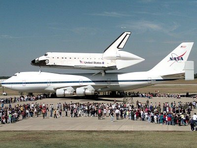 Below is a satellite image of the Shuttle landing strip and hanger, with the large piggy-back plane they use to transport the shuttles back and forth. An 11-story crane, for lack of better description, lifts the shuttle and lays it on the top of the plane, as seen in the picture above

 Museum circle, with various rockets and planes. Note the shadows for the rockets
One last image below you can see all the various launch pads, some retired and some still in use for various rockets and space missions.
Explore Cape Canaveral with Google Maps!

No comments:
Post a Comment