Friday, April 07, 2006
World's Tallest Building-Stats
Check out the World's Tallest building. It's the Burj Dubai in the U.A.E.
At least when it opens in 2008, it'll be the tallest.
There are already plans to build taller buildings, including the monster Al Burj.


Quick Links Update
Some additions to note-
Horry County, South Carolina GIS and Assessor Link
St. Francois, Missouri Assessor Link
Greene County, Missouri Assessor Link
Jefferson County, Missouri Assessor Link
Phillipsburg, Maine Assessor Link W/Tax Maps and Search
Wednesday, April 05, 2006
GIS Links-State and County GIS Links-A comprehensive list of GIS sites
I have more skyscraper pages for you. Although it has very little to do with GIS, I found it fun.
http://www.skyscraperpage.com/diagrams/
GIS Links-State and County GIS Links-A comprehensive list of GIS sites
Tuesday, April 04, 2006
THE WORLDS TALLEST BUILDINGS-IN ONE PICTURE
 SKYSCAPERNEWS.COM has posted a rather unique photo of all the world's tallest skyscapers and placed them into one background. Make sure to click 'enlarge' to view all of the buildings.
Skyscrapers Skyline
Monday, April 03, 2006
Watercrest Flood Verification.
Watercrest Flood is alive on the web. Check out the satellite image of our builiding,
WaterCrest Flood Verification, Inc.
Sunday, April 02, 2006
NASA Satellite Maps
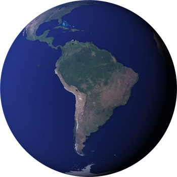 The hard working people at NASA are known for their work looking at the stars, but few think about how much time they spent watching our own Earth. Head over to their Earth Observation Room and check out their high res pictures of the Earth. Then hit their 'data & images' page and you can make your own maps using their data.
Earth Observation Room
Data & Images
Daily Timekiller - Solar System Live
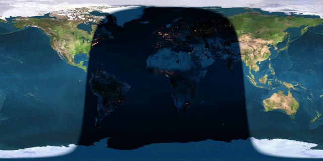 I get a lot of requests for the previous post on the Earth at Night. The same website has a few other nice pages to mention. It's run by John Walker out of Switzerland and you can find his main page at http://www.fourmilab.ch/
First, there is a live map of the planets in relation to the sun.
http://www.fourmilab.ch/cgi-bin/uncgi/Solar/action?sys=-Sf
Second, there is a nice sky chart showing the stars and their formations at any given location. Just update the lat and long and click for a map and you can see what your missing.
http://www.fourmilab.ch/cgi-bin/uncgi/Yoursky
Friday, March 31, 2006
How Monty Python Saved the World,...kinda.

How come students throughout the world can't find their own country on a map? One person you can thank is former Harvard President James Conant who, in 1948, announced to the world that geography is not a university subject, and banished the subject from his school. http://www.suntimes.com/output/otherviews/cst-edt-ref181.html
Nice. Thanks Harvard. Now I'm sure that decision would not have any negative effects on future students. Well, we can now thank Monty Python for helping to bring Geography back to the students. England is now making a travel book by Monty Python member Michael Palin a mandatory read for its students to help bring up the horrid scores of the worst-taught subject in British schools.
http://www.cbsnews.com/stories/2006/03/30/print/main1458327.shtml
Wednesday, March 29, 2006
Daily Timekiller - 10 Weird Things Found on Google Maps
 LONNIE SPATH, of PostStar.com, has posted a fun article for all the Geography geeks, like myself, out there who jump onto Google Maps to find odd things. So, in the spirit of things, I have added a few links myself of some fun things I found on Google Maps.
http://www.poststar.com/specials/earth.asp
#1 - Skywalker Ranch. Ever wonder where Luke Skywalker was born. Well, it's in the mind of the guy who built this. You might know him as George Lucas, who also made ILM and PIXAR Animation, which he sold to Steve Jobs, of Apple Computers fame.
http://www.google.com/maps?ll=38.061101,-122.649887&spn=0.015611,0.028925&t=k
Article on Skywalker Ranch, for reference - http://george.lucas.net/prologue3.htm
#2 Apple Computers, home of the iPod. And Steve Jobs.
http://www.google.com/maps?f=q&hl=en&q=apple+computers,+sunnyvale,+ca&ll=37.332187,-122.029846&spn=0.008497,0.014462&t=k
#3 Nike Headquarters. This is one of the most lush, landscaped sites I've been to. I visited and parked in Michael Jordan's parking spot. Although the parking spot is there for formality, it didn't stop me from wishing Mr. Jordan would pull up and ask me to get the heck out of his spot. Nike founder Phil Knight has bought an animation studio in Portland, Oregon, called Laika Studios. He wants to created digital and stop action animaton films to compete with Pixar and DreamWorks. See a trend here?
http://www.google.com/maps?f=q&hl=en&sll=45.477526,-122.823801&sspn=0.029971,0.05785&q=nike&ll=45.508693,-122.828307&spn=0.01497
#4- Nothing to do with movies or animation, but an attraction that begs the question- Why? Welcome to South Dakota's 'Corn Palace', the only building built from corn.
Corn Palace Web Site: http://www.cornpalace.org/
http://www.google.com/maps?f=q&hl=en&q=601+N+Main+Street,+57301&ll=43.714546,-98.025668&spn=0.003862,0.010815&t=h
#5 - Google Headquarters.
Got to give them some credit for Google Maps and it looks like they have taken advantage of it by getting a little artistic with their own satellite image. Oh well, they own they system so I guess they can do what they want with it.
http://maps.google.com/maps?q=1600+Amphitheatre+Parkway,+Mountain+View,+CA+94043+(Googleplex)
Earth As Art.

Enjoy the images taken by satellites of various parts of the Earth. The USGS site has gathered some of the more memorable images and presented them as "EARTH AS ART", a nice website using Landsat-7 satellite images.
Daily Updates


Tuesday, March 28, 2006
Don't Shoot the Puppy - A good time killer.
 http://www.rrrrthats5rs.com/games/dont-shoot-the-puppy/
'Don't shoot the Puppy' is a flash-game where you try not to pull the trigger on old rover. Start the game and don't do anything. If you move the mouse, the puppy gets shot. There are levels where the puppy takes his time and tries to encourage you to shoot it, but don't fall for it. The longer you 'don't shoot', the higher the score.
Monday, March 27, 2006
Updates for Arizona and North Carolina GIS Links.
 For Monday, I have added Stokes County, North Carolina GIS site and Hoke County North Carolina GIS site. For Arizona, I have added Gila County GIS and Assessor site together because of the lack of search function for their GIS site. Also, Apache County, AZ GIS site and assessor links for Graham, Greenlee, Mohave, Santa Cruz, and Yuma, AZ. For Alabama, Etowah County, and Lauderdale County Assessor links and Marshall County and Baldwin County GIS links.
Sunday, March 26, 2006
MultiMap.com
 Multimap.com – Online Maps to Everywhere.
A good world Atlas to kill some time. It has a worldwide database and allows to zoom in and see actual street maps of different countries.
Multimap.com – Online Maps to Everywhere

Saturday, March 25, 2006
Live Image of Earth from Space
 Earth View is a neat site with live images of the Earth from space taken by various satellites. Click and paste the links for now-Blogger's having some issues and I can't put hyperlinks on at the moment.
http://www.fourmilab.ch/cgi-bin/uncgi/Earth/action?opt=-p
This second links takes you to the Earth View homepage, which allows more options to view. Here is also a link to view the moon.
http://www.fourmilab.ch/earthview/vplanet.html
FEMA Flood Map Information
 FEMA Flood Maps are a constant source of questions for anyone buying a home and given the news that 'your house is in a floodplain.'
For those of you that have questions about what all the FEMA terms mean or just think FEMA's all wrong about where you live and can't map worth a darn, then here's a good link from WATERCREST FLOOD VERIFICATION with some good answers. Also, I have included the direct link to FEMA for anyone that wants to call them and get vague answers to your serious questions.
http://www.watercrestflood.com/loma.html
http://www.fema.gov/
TEXAS County GIS + Assessor Links Updated
 Texas Counties for GIS and Assessor Links have been updated up to the letter 'T'. I was able to get a few more in the list than I scheduled, but U-Z will get updated by next week.
As per Texas, most counties do not have a direct GIS link as of yet. However, they are constantly updating and even though these are assessor links, some have GIS links in them. Others have Plat or Tax maps, while some are just basic legal information.
New York City Maps.
 I have linked 3 sites to New York City today that include the New York City GIS Link (NYC portal), a link to maps with parking throughout the area, and one link for GIS data in ESRI shapefiles and MAPINFO.
Subscribe to:
Posts (Atom)