 A worldwide map of each countries practices in capital punishment. Click on the image above to view the full size map.
Sunday, December 31, 2006
Capital Punishment Laws of the World Map
A worldwide map of each countries practices in capital punishment. Click on the image above to view the full size map.
Thursday, December 28, 2006
The Top 8 Earth Science Stories of 2006
 Global warming as hot topic, water worlds under Antarctic ice, King Tut's alien heat source, and more. Check out the top 8 Earth Science stories of 2006! [via]
Tuesday, December 26, 2006
Fears of Tsunami Ease After Taiwan Quake

A powerful earthquake struck off southwestern Taiwan on Tuesday, briefly prompting fears of a tsunami on the second anniversary of the quake and deadly waves that killed thousands in south Asia.
Taiwanese media reported one person died and three were injured when their home collapsed in the southern city of Pintung. Other reports said city streets had cracked and a major bridge was damaged. They said fires were burning out in the area, apparently caused by downed power cables.
The quake was felt throughout Taiwan. The U.S. Geological Survey estimated its magnitude at 7.1, while Taiwan's Central Weather Bureau measured it at 6.7. It was followed eight minutes later by 7.0 magnitude aftershock, the USGS said.
Two hours later, an official at Japan's Meteorological Agency said there was no longer any danger of a destructive tsunami headed for the Philippines, as had been predicted. ...continue article...
Sunday, December 24, 2006
Happy Holidays!
 Merry Christmas to everyone who has helped make this site possible and a success. I wish the best to you for your holiday season.
Google Buys Endoxon

Google has bought Endoxon, a Swiss company focused on web-based geo information services. The company provided imagery for map.search.ch, a successful map service, and local.ch, a local search service - both limited to Switzerland.
Endoxon has been working on a technology called "blue", that extends their products to the whole world. "blue is visualized information on the web. blue is the clever linking of a world map server, a search engine and a GIS. blue is a high-quality, comprehensive points- and map server, a virtual worldwide marketplace, a search and services platform. The user can search for information or he can visualize his own collected information. The download of selected blue data onto the mobile phone is possible. But blue is not only a vision. Its reality: Endoxon has been collecting, enhancing and geo referencing worldwide satellite and aerial images for a couple of years now."
Google acquired Endoxon's internet, mapping and data processing business units. Google says the acquisition "will enable us to leverage their analysis capabilities and will help us build out and improve the functionality of Google Earth and Google Maps across Europe."
Thursday, December 21, 2006
The worlds top 100 wonders, how many have you seen?
 The author has a 514 page guide to all things wonderful in the world. Think of it as a fun travel guide, and a guy with a passion for the world that has been around since 1968: "The Hillman Wonders list".
I know, I never heard of him to until I drop into the site. Enjoy
read more digg story
The author has a 514 page guide to all things wonderful in the world. Think of it as a fun travel guide, and a guy with a passion for the world that has been around since 1968: "The Hillman Wonders list".
I know, I never heard of him to until I drop into the site. Enjoy
read more digg story
Wednesday, December 20, 2006
NEWSMAP
 Here's a neat site. It's called a NEWSMAP and I was directed to it because of the "Map" in the title. It's like DrudgeReport crossed with a map. It's mostly on one screen and you'll get an idea of what it's about once you check it out. It's pretty cool and updates around the world news and sports, as well as tabs to filter out certain subjects.
 Here's a little about the site:
- Newsmap is an application that visually reflects the constantly changing landscape of the Google News news aggregator. A treemap visualization algorithm helps display the enormous amount of information gathered by the aggregator. Treemaps are traditionally space-constrained visualizations of information. Newsmap's objective takes that goal a step further and provides a tool to divide information into quickly recognizable bands which, when presented together, reveal underlying patterns in news reporting across cultures and within news segments in constant change around the globe.Newsmap does not pretend to replace the googlenews aggregator. Its objective is to simply demonstrate visually the relationships between data and the unseen patterns in news media. It is not thought to display an unbiased view of the news; on the contrary, it is thought to ironically accentuate the bias of it.
Tuesday, December 19, 2006
NASA Launches Google Collaboration

By Marc Kaufman Washington Post Staff Writer
Tuesday, December 19, 2006
NASA, seeking to give the public easy access to its massive trove of images and data about Earth and outer space, has entered into a formal agreement with Google to post material from the agency's many missions on the Internet. As the technology improves and the collaboration grows, officials said, viewers could one day be treated to live video from the moon, Mars and elsewhere.
"This agreement between NASA and Google will soon allow every American to experience a virtual flight over the surface of the moon or through the canyons of Mars," NASA Administrator Michael D. Griffin said in a statement. He called the effort one "to make NASA's space exploration work accessible to everyone."[...continue article...]
Also, from Reuters:
Monday, December 18, 2006
GOOGLE EARTH messages with buildings!
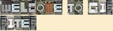 Share the joy of satellite imagery with friends and loved ones today. Welcome to Geo Greeting, where buildings in Google Earth become letters for any message you want to enter in and send to friends and family.
Sunday, December 17, 2006
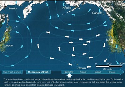
PACIFIC TRASH VORTEX

The very thing that makes plastic items useful to consumers, their durability and stability, also makes them a problem in marine environments. Around 100 million tonnes of plastic are produced each year of which about 10 percent ends up in the sea. About 20 percent of this is from ships and platforms, the rest from land.
These larger items are the visible signs of a much larger problem. These big items do not degrade like natural materials. At sea and on shore under the influence of sunlight, wave action and mechanical abrasion they simply break down slowly into ever smaller particles.
A single one litre drinks bottle could break down into enough small fragments to put one on every mile of beach in the entire world. These smaller particles are joined by the small pellets of plastic which are the form in which many new plastics are marketed and which can be lost at sea by the drumload or even a whole container load. These modern day “marine tumbleweeds” have been thrown into sharp focus, not only by the huge quantities removed from beaches by dedicated volunteers, but by the fact that they have been found to accumulate in sea areas where winds and currents are weak.
LEARN MORE ABOUT THE PACIFIC TRASH VORTEX
Watch the PACIFIC TRASH VORTEX
Thursday, December 14, 2006
Space Shuttle Discovery Fun Facts.

Space Shuttle Discovery Launch. This week’s Cellar/Neatorama pick of the week is the spectacular photo is of the night launch of the Space Shuttle Discovery on December 9, 2006. This is the first night space shuttle launch the first since the 2002 Endeavour launch (other launches since the 2003 Columbia disaster were done during the day so controllers can see the shuttle’s external fuel tank in case of foam falls off).
In this current mission (STS-116), Discovery will dock with the International Space Station to deliver equipments and new station crew member. This mission is the 117th space shuttle flight and the 33rd flight for Discovery.
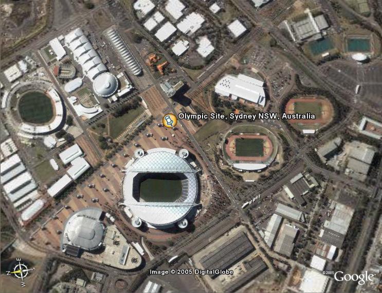
Santa's Toy Hunt and Santa Tracker in Google Earth.
 Santa has hidden a treasure trove of presents somewhere in Google Earth (actually, it was a few of his elves, but you get the idea) . Every day from December 12th until Christmas Eve, a clue will appear outside Santa's North Pole workshop which, if you can solve it, will lead you to a toy hidden in a Google Earth satellite image. And every day, the location of the previous day's toy will be revealed.
Wednesday, December 13, 2006
Endangered gorillas prosper in heart of Africa
 By Marie-Louise Gumuchian
PARC NATIONAL DES VOLCANS, Rwanda (Reuters) - One hour's trek into the Rwandan rainforest, a crunching sound breaks the silence that hangs over the misty thick bush. Slow and loud, it lasts for a few minutes, then stops abruptly. Suddenly a gorilla's face peers through the giant nettles to look at the tourists who have sweated along jungle trails to catch a glimpse of him and his family. The 200-kg (440-lb) male, the silver-grey saddle on his back signaling maturity, studies his visitors. Then, his curiosity satisfied, the mountain gorilla emerges from the bush, crawls to the top of a clearing on the lush mountainside and continues loudly chomping on his bamboo shoot. A female follows and stretches out next to the silverback, keeping a careful eye on the intruders as her babies playfully fight, thumping their chests and rolling down the hill. Their low-pitched grunts are answered in kind by a guide so both humans and gorillas know the others are just observing. "Look at those babies," one tourist marvels. "Aren't they amazing?" Agashya and his family are among the world's 700-odd surviving mountain gorillas who live in their natural habitats in Rwanda, Uganda and Democratic Republic of Congo. Split between the Virunga volcanoes which straddle the borders of the three central African countries and Uganda's Bwindi National Park, the gorillas have actually seen their numbers increase in the last few years. Continued...
By Marie-Louise Gumuchian
PARC NATIONAL DES VOLCANS, Rwanda (Reuters) - One hour's trek into the Rwandan rainforest, a crunching sound breaks the silence that hangs over the misty thick bush. Slow and loud, it lasts for a few minutes, then stops abruptly. Suddenly a gorilla's face peers through the giant nettles to look at the tourists who have sweated along jungle trails to catch a glimpse of him and his family. The 200-kg (440-lb) male, the silver-grey saddle on his back signaling maturity, studies his visitors. Then, his curiosity satisfied, the mountain gorilla emerges from the bush, crawls to the top of a clearing on the lush mountainside and continues loudly chomping on his bamboo shoot. A female follows and stretches out next to the silverback, keeping a careful eye on the intruders as her babies playfully fight, thumping their chests and rolling down the hill. Their low-pitched grunts are answered in kind by a guide so both humans and gorillas know the others are just observing. "Look at those babies," one tourist marvels. "Aren't they amazing?" Agashya and his family are among the world's 700-odd surviving mountain gorillas who live in their natural habitats in Rwanda, Uganda and Democratic Republic of Congo. Split between the Virunga volcanoes which straddle the borders of the three central African countries and Uganda's Bwindi National Park, the gorillas have actually seen their numbers increase in the last few years. Continued...
GOOGLE EARTH news
 A couple of GOOGLE EARTH bits to pass on to you:
- Department of Homeland Security Selects ESRI for GIS Enterprise License Agreement
- Pennsylvania to Use Google Earth Mapping Tool to Promote Tourism
- Huge willy seen on Google Earth
- Opening my eyes to a whole new world
- Google Earth Meets Wikipedia & Geographic Web Layering
- Google's Geographic Layer
Monday, December 11, 2006
Why the Dead Sea is dying
 Only a minute’s walk from the fast-receding coastline of the Dead Sea is the starkest evidence of what environmentalists have feared for years. Decades of a policy to drain water from the Sea of Galilee and Jordan River to turn the deserts green have inflicted a heavy cost — the shrinking of the Dead Sea, and the alarming appearance of fissures and sinkholes on its shores.
 Faced with an ecological disaster and driven by an insatiable thirst for water in the Middle East, officials from Israel, Jordan, the Palestinian Authority and the World Bank will gather beside the lowest-lying body of water on Earth tomorrow to launch a feasibility study aimed at saving the rapidly disappearing biblical waters.
[...continue article...]
Faced with an ecological disaster and driven by an insatiable thirst for water in the Middle East, officials from Israel, Jordan, the Palestinian Authority and the World Bank will gather beside the lowest-lying body of water on Earth tomorrow to launch a feasibility study aimed at saving the rapidly disappearing biblical waters.
[...continue article...]
Antarctica Erupts!
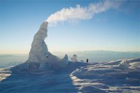 A trip to Mount Erebus yields a rare, close-up look at one of the world’s weirdest geological marvels.
Mount Erebus' ice caves are among the most promising places for undiscovered life in Antarctica. Though they grow or shrink depending on how much heat the volcano emits, inside they maintain a temperature of about 32 degrees.
A trip to Mount Erebus yields a rare, close-up look at one of the world’s weirdest geological marvels.
Mount Erebus' ice caves are among the most promising places for undiscovered life in Antarctica. Though they grow or shrink depending on how much heat the volcano emits, inside they maintain a temperature of about 32 degrees. 
George Steinmetz was drawn to Mount Erebus, in Antarctica, by the ice. The volcano constantly sputters hot gas and lava, sculpting surreal caves and towers that the photographer had read about and was eager to see. And though he'd heard that reaching the 12,500-foot summit would be an ordeal, he wasn't prepared for the scorching lava bombs that Erebus hurled at him.
Geography IQ
 Welcome to GeographyIQ.com. GeographyIQ is an online world atlas packed with geographic, economic, political, historical and cultural information. In addition, GeographyIQ brings together a number of other resources including maps, flags, currency conversion as well as climate and time zone information.
Sunday, December 10, 2006

Friday, December 08, 2006
Former President Jimmy Carter : 'PLAGIARIZING MAPS' IN PALESTINE BOOK...
President Jimmy Carter faced new criticism Friday over his controversial book on Palestinian lands when a former Middle East diplomat accused him of improperly publishing maps that did not belong to him.
The new charge came as Carter attempted to counter charges from a former top aide that the book manipulates facts to distort history.
Ambassador Dennis Ross, a former Mideast envoy and FOX News foreign affairs analyst, claims maps commissioned and published by him were improperly republished in Carter's book.
"I think there should be a correction and an attribution," Ross said. "These were maps that never existed, I created them."
After Ross saw the maps in Carter's book, he told his publisher he wanted a correction.
When asked if the former president ripped him off, Ross replied: “it sure looks that way.”
[...continue article...]

Thursday, December 07, 2006
Monterey Bay Aquarium Live Webcams
 Check out the Otter cam!
Our live web cams offer a look at marine life in our exhibits and off our oceanfront decks from 7 a.m. to 7 p.m. Pacific Time. They're also a gateway to information about ocean habitats and conservation topics.
Maps of Italy
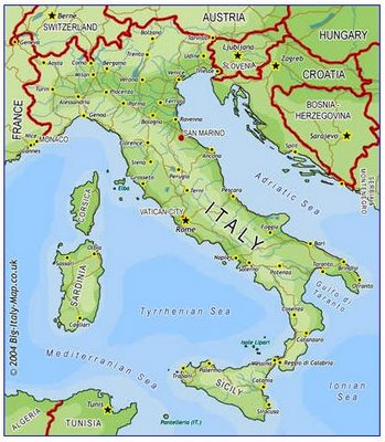 Map of Italy is an Italian Atlas site dedicated to providing royalty free maps of Italy, maps of Italian cities and links of maps to buy.
Tuesday, December 05, 2006
10 Most Impressive Satellite Photos
 Ancient Lost City of Angkor Wat
10 Most Impressive Satellite Photos
Ancient Lost City of Angkor Wat
10 Most Impressive Satellite Photos NASA Schedules Briefing to Announce Significant Find on Mars

Hmmmm....interesting!
Wonder what it could be...?
WASHINGTON - NASA hosts a news briefing at 1 p.m. EST, Wednesday, Dec. 6, to present new science results from the Mars Global Surveyor. The briefing will take place in the NASA Headquarters auditorium located at 300 E Street, S.W. in Washington and carried live on NASA Television and www.nasa.gov.
The agency last week announced the spacecraft's mission may be at its end. Mars Global Surveyor has served the longest and been the most productive of any spacecraft ever sent to the red planet. Data gathered from the mission will continue to be analyzed by scientists.
**************************
Update: Does water STILL flow on Mars?
NASA TV - ONLINE FEED
District of Columbia Boundary Stones: Photos & Locations

The District of Columbia is a diamond-shaped square, ten miles on a side. In 1791-92 Andrew Ellicott, with Benjamin Banneker and colleagues, slashed through the wilderness, surveyed the bounds of the Federal City, and placed marker stones every mile along the edge. Many of these forty historic stones yet survive. My self-imposed quixotic mission: visit them, photograph them, and record their GPS coordinates. Here's a Google Map of the results. Click on a marker to get high-resolution imagery and a locator map for that stone.
Monday, December 04, 2006
TeleGeography Maps
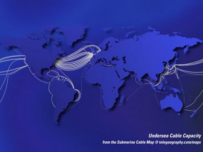 This is a site that sells TeleGeography maps of various subjects. TeleGeography centers around Broadband/Internet and Cable, both underwater and terrestial.
Sunday, December 03, 2006
Whalesong Project : Bringing you whale songs from Kihei, Maui

Share the songs of Hawai'i's whales with the world, live over the Internet, during the islands' humpback whale season (November to June) through our website www.whalesong.net .
Whalesong is a project inspired by the beauty of oceans. This beauty includes not only the visual aspects of the water planet we live on, but also a mysterious and incredible world of sound, which whales and dolphins use to navigate and communicate across vast oceans. The vocalizations of these ancient cetaceans have inspired music, poetry, scientific discovery, and perhaps even languages and cultures.
These magnificent marine mammals and the messages that they communicate face new challenges as the sonic world of the seas becomes the testing ground for high powered sonar systems and new military technologies, scientific research that utilizes high intensity sound, undersea explosions related to the search for oil and minerals, as well as other human activities.
Deception Island
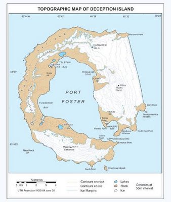 Deception Island (62°57'S, 60°38'W) is one of the most incredible islands on the planet.
It is an active volcano in the South Shetland Islands, off the Antarctic Peninsula. Its unique landscape comprises barren volcanic slopes, steaming beaches and ash-layered glaciers. It has a distinctive horse-shoe shape with a large flooded caldera. This opens to the sea through a narrow channel at Neptunes Bellows, forming a natural sheltered harbour. It is one of the only places in the world where vessels can sail directly into the centre of a restless volcano.

This site contains an Introduction to this unique and fascinating island of fire and ice. It also contains the Management Plan adopted by the Antarctic Treaty Nations, as well as the Terms of Reference for the Deception Island Management Group.
Flight Tracking in 3D
 Just in time for the holidays.
Cool Stuff! See live inbound traffic for a number of US-based airports, live and in 3D using Google Earth!
Click to FBO Web for detailed flight tracking, flight planning and aeronautical information!
Just in time for the holidays.
Cool Stuff! See live inbound traffic for a number of US-based airports, live and in 3D using Google Earth!
Click to FBO Web for detailed flight tracking, flight planning and aeronautical information!
Latitude/Longitude Position Finder

Use this resource to identify the latitude and longitude position of any point within the United States. Simply touch the map below to zoom in on the area you select, until you find the precise location. There are 9 zoom levels in all. You may zoom out if the position is not on the visible portion of the map.
The Galaxy at your hands
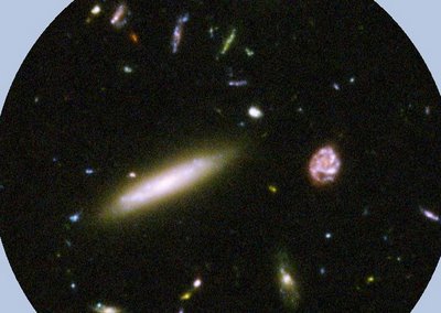 The Ultra Deep Field obtained by the Hubble Space Telescope is the deepest view into the sky by humankind to date. This image combines 800 frames with a total exposure time of 1 million seconds. The 10.000 galaxies that are visible have distances out to times where the universe was just 800 million years old, one seventeenth of its current age
Subscribe to:
Posts (Atom)