 Many consider this one of the best sites for cosmic downloads. There are downloads for the universe you can get for your computer to play with. The Hayden Planetarium is part of the American Museum of Natural History in New York City.
Click here for Hayden Planetarium Link.
Many consider this one of the best sites for cosmic downloads. There are downloads for the universe you can get for your computer to play with. The Hayden Planetarium is part of the American Museum of Natural History in New York City.
Click here for Hayden Planetarium Link. Wednesday, May 03, 2006
Download the Universe to your computer.
Many consider this one of the best sites for cosmic downloads. There are downloads for the universe you can get for your computer to play with. The Hayden Planetarium is part of the American Museum of Natural History in New York City.
Click here for Hayden Planetarium Link. Mars Atlas
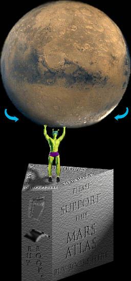 More stellar mapping online with an Atlas of Mars from roving-mouse.com. Not sure who they are, but they have compiled images of the Martian soil for your viewing. After you click on the link, hit anywhere on the image of Mars to the left and it will take you to the images. Crude, but effective.
 Lunar Atlas

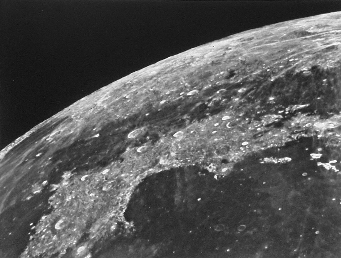
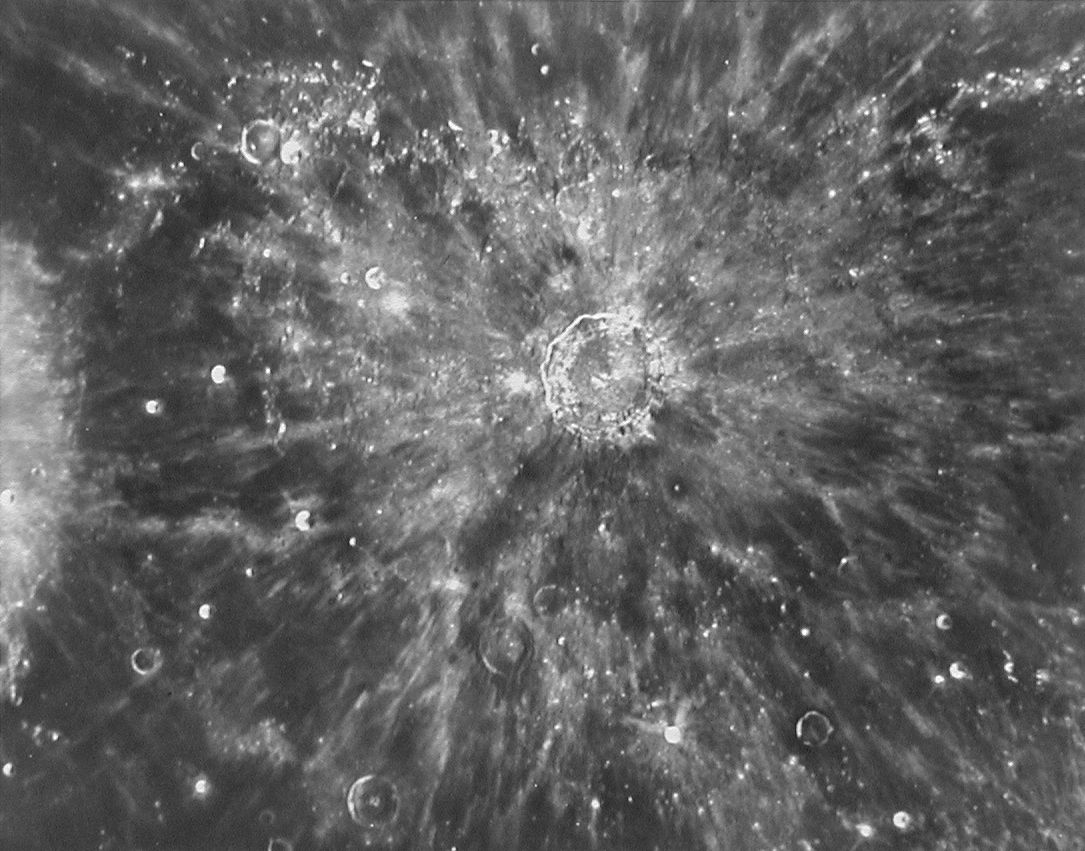
Burn some time up with this lunar atlas. Be sure to check out the map catalog and cool pictures of the moon's surface. The website is from the Lunar and Planetary Institute out of Houston, TX. Overall, they have put together a good site with easy navigation.
Tuesday, May 02, 2006
Fun with Google Maps-Baseball Geography of the A.L. East.
Google maps is a great way to see some familiar areas with a new perspective. I continue the tour of the A.L. with the East, home of the Yankees and Red Sox. I have already done the A.L. West and Central which can be found here:
A.L. WEST LINK
A.L. CENTRAL LINK


BALTIMORE ORIOLES-ORIOLE PARK @ CAMDEN YARDS

When the Orioles built Camden Yards in 1992, they not only set a trend in retro-ballparks (Cleveland, Arlington, SafeCo...), they also created one of the best ballparks ever. The grounds are beautiful and there's not a bad seat in the house. Just south is the Ravens Stadium and the Baltimore Harbor is directly east. When Cal Ripken, Jr. broke the consecutive games played record, Camden Yards became an instant shrine.


BOSTON RED SOX-FENWAY PARK

The Boston Red Sox. Only the Yankees can compare in having such a rich history. The Red Sox finally brought an end to the Curse of Babe Ruth, who went to the New York Yankees, by winning the World Series in 2004. The Boston Red Sox have fielded some of baseballs greatest players, ranging from Babe Ruth to Roger Clemens. You also can't leave out the Green Monster in left field. On the satellite image, you can see why they had to create the wall to match the road next to it. Fenway is now the oldest park still in use, after Detroit opened their new stadium a couple of years back.
NEW YORK YANKEES-YANKEE STADIUM


Only the NHL's Montreal Canadians(23) can rival the New York Yankee's (26) in the number of World Championships. There's a little too much history to go over here, but let's just say, the Yankees are world known for winning over the last 100+ years. Ruth, Maris, Gehrig, DiMaggio, Jackson, Jeter... The list goes on. Anyway, check out the confines of the Yankees which is known as the House that Ruth built. The Stadium was the first ballpark to be called a 'stadium' and not field or grounds.
However, when you type in Yankees stadium in Google Maps, it takes you to Madison Square Gardens. Odd.
TAMPA BAY DEVIL RAYS-TROPICANA FIELD

In 1998, the expansion Tampa Bay Devil Rays hit the circuit and haven't done much since. While their Flordia pals, the Florida Marlins, have won 2 World Series titles already, the Rays have shown spurts of a good team, but just haven't gotten it together. They play at the Tropicana Field which is a dome. Go figure. The southern most team in the east, and keep in mind there are Boston and New York represented, play in sunny Florida under a dome. The dome is slanted toward the infield and has catwalks running along the inside of the dome, which result in balls bouncing off them. The stadium was started in 1986 to bring a team like the White Sox, or other team with financial woes, to Flordia. All the efforts failed until 1998, when the Rays became the 2nd team in Flordia, after the Marlins.

TORONTO BLUE JAYS-ROGERS CENTRE
Rogers Centre in Toronto, Ontario was built in 1989 as the SkyDome and ushered in an era of retractable domed stadiums. The stadium has a domed roof that splits open to reveal the field to the elements. The Jumbotron is over 100 ft wide and was the largest of its kind for a decade. Rogers Centre sits below the giant CN Tower, which can be seen in the satellite photo to the right.
Sunday, April 30, 2006
National Geographic MapMachine

National Geographic MapMachine.
National Geographic and ESRI have created a site to utilize the great mapping of the National Geographic and the online software of ESRI so you can browse maps and themes from throughout the world. Click here for MapMachine.GIS Sites-Links for GIS Maps
Georgetown County GIS, South Carolina added.
GIS Sites-Links for GIS Maps
Thursday, April 27, 2006
Anson County NC GIS link.
I have added a link to Anson County GIS, North Carolina. It has full GIS with parcel search and payments options.
Senate Panel Recommends Abolishing FEMA
A new Senate bill proposed would call for the elimination of FEMA.
Click Here for Yahoo! News Article
Tuesday, April 25, 2006
NEW ADDITIONS
 Today, I have added 34 new GIS pages for the states section. I have also beefed up the world section with almost 20 new GIS pages of various sorts.
First, for the U.S.:
Auburn city GIS, AL; Anchorage, Alaska GIS; Little Rock City, Arkansas GIS; West Sacramento, California GIS; Hayward, Culver City, Azusa, Downy, Carson, and Laguna Beach City GIS, California; Fort Collins, Colorado GIS; Groton, Conn. GIS; Marietta City, Georgia, GIS; Linn County, Iowa GIS; Overland Park City, Kansas GIS; Kentucky Links-various, but include Campbell, Kenton, Boone, and Pendleton; Concord city, Mass. GIS; Meridian Township, MI GIS; Las Vegas, NV GIS; New Jersey Meadowlands Flood Incident GIS; New Windsor, NY GIS; Gaston County, Forsyth County, and Bladen County NC GIS; Pennsylvania and Texas Digital Atlas (Both GIS applications); Sioux City, SD GIS; Plano city, Denton County, and College Station GIS, TX; and Ogden City, UT GIS.
I had fun with the world GIS maps. I have included Maine Whale sightings and Lobster Tails, a sight to report and map Maine Lobsters around the world.
Also, the Baltic, Mediterranean, Black, and Caspian Seas GIS sites. Austria sites includes Linz, Austrian Federations, and Austrian Environment.
The UK has South Ayrshire GIS and Nottingham GIS. And there's also West and South Atlas of Australia, Sydney Australia GIS; Wroclaw, Poland; Israel; Iraq (which doesn't work all the time); Dubai (down, but will be up soon) and the Caribbean Sea.
Enjoy.
Today, I have added 34 new GIS pages for the states section. I have also beefed up the world section with almost 20 new GIS pages of various sorts.
First, for the U.S.:
Auburn city GIS, AL; Anchorage, Alaska GIS; Little Rock City, Arkansas GIS; West Sacramento, California GIS; Hayward, Culver City, Azusa, Downy, Carson, and Laguna Beach City GIS, California; Fort Collins, Colorado GIS; Groton, Conn. GIS; Marietta City, Georgia, GIS; Linn County, Iowa GIS; Overland Park City, Kansas GIS; Kentucky Links-various, but include Campbell, Kenton, Boone, and Pendleton; Concord city, Mass. GIS; Meridian Township, MI GIS; Las Vegas, NV GIS; New Jersey Meadowlands Flood Incident GIS; New Windsor, NY GIS; Gaston County, Forsyth County, and Bladen County NC GIS; Pennsylvania and Texas Digital Atlas (Both GIS applications); Sioux City, SD GIS; Plano city, Denton County, and College Station GIS, TX; and Ogden City, UT GIS.
I had fun with the world GIS maps. I have included Maine Whale sightings and Lobster Tails, a sight to report and map Maine Lobsters around the world.
Also, the Baltic, Mediterranean, Black, and Caspian Seas GIS sites. Austria sites includes Linz, Austrian Federations, and Austrian Environment.
The UK has South Ayrshire GIS and Nottingham GIS. And there's also West and South Atlas of Australia, Sydney Australia GIS; Wroclaw, Poland; Israel; Iraq (which doesn't work all the time); Dubai (down, but will be up soon) and the Caribbean Sea.
Enjoy.
FUN WITH GOOGLE MAPS-EUROPE!
Here are some Google Map finds from Europe.
Battle and cruise ship. In London, England.
Barcelona, Spain. This is a mesmerizing overhead view of an old city. The street layout and condensed housing make a neat pattern.
The Eiffel Tower, France.
Petronas Towers, Kuala Lumpur, Malaysia. Once the world's tallest buildings, these twin towers now fall short of the Taipei 101.
Vatican City.
Fernsehturm, Berlin, Germany Around 1,100 ft tall, this tower was used by the East German government when Berlin (and Germany) was divided into East and West. It once was used for TV and radio from the Communist Government of East Germany and is now a tourist spot with a cafe on the observation deck, about 650 ft up. It looks like an olive on a toothpick so be sure to check out the homepage to understand it's height. Pan to the left and look in the park to see the large, golden statue on the pedistal used in a lot of European films.
Link: Berlin Television Tower
Yahoo! Maps with Satellite images, Big $, and European Road now on Satellite Maps.

Yahoo! Maps now have Satellite Images.
In case you have missed it, Yahoo! Maps have slowly introduced satellite images into its new Beta version of maps. It's hard for the average person to discover the satellite images as Yahoo! doesn't really advertise it as of yet. But, go to Yahoo! Maps and click on the Beta version of maps. When Yahoo! puts some of their advertising weight behind it, Yahoo! Maps will easily rival Google Maps for easy use and quality. Google Maps has a simple button that allows for a quick link and for Yahoo! Maps you can just cut and paste the url for the coordinates.
Here's the Helena, MT test. I took satellite images of the capital in Helena, MT for you to compare on the different mapping engines. The reason I chose Helena is because it shows how far satellite mapping has come. It's easy to find Manhattan or L.A. satellite images, but to really map the world, a program must actually have useful and current images of places off the beaten path.
Yahoo! Maps: Helena, MT satellite image.
Google Maps: Helena, MT satellite image.
MSN Virtual Earth: Helena, MT satellite image.
As you can see by the comparison of the 3 images, Yahoo! is clear but doesn't come close to the zoom that Google has in this case. MSN is just outdated, being an image from the mid nineties and in B & W. On a personal note, I actually use MSN more than the others because even being outdated, they have more coverage across the U.S. than Google or Yahoo! But, that's changing with each passing month. But, now that it's become big business, the others are all catching up.

Online Mapping is Big Business.
Here's a quick link to a Forbes article about the boom in online satellite mapping. It goes into great detail about the new rivalry of the industry and how Yahoo! Maps actually beat out Google Maps recently in usage.
Click here for: Forbes Article.
Europe Road Names on Google Maps.
Google Maps has made a dramatic improvement to its service by adding European road names to its database. While it's not perfect or finalized, it is a start.
Click here for: Google Maps Europe.
Google Earth - Hi Res updates for Maldives and Europe.
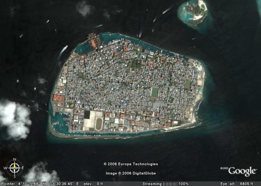 GoogleEarthBlog.com has created a link for the Google Earth update from late March. Included are new, hi-res files for the Maldives, among others, which allow the viewer to actually see airplanes flying over the ocean.
The satellite images of the Maldives are detailed enough to make out a giant sailboat and even strings of cabanas stretching out into the lagoons. If you've never had a chance to study up on the Maldives, Google Earth provides a good jumping point to see the chain of low level islands that are southwest of India. They are so low in elevation that almost all habitable land is occupied as seen in the picture above.
Follow the link from the Google Earth Blog to open the file in Google Earth. As long as you have Google Earth installed, it just takes one click and all the work is done for you. Don't worry about downloading or opening files. If you don't have Google Earth, then you missing out on a great virtual tour of the Earth that is continuously updated.
Click Here for: Google Earth.
Click Here for: Google Earth Blog
Click Here for: Maldives Hi-Res on Google Earth.
GoogleEarthBlog.com has created a link for the Google Earth update from late March. Included are new, hi-res files for the Maldives, among others, which allow the viewer to actually see airplanes flying over the ocean.
The satellite images of the Maldives are detailed enough to make out a giant sailboat and even strings of cabanas stretching out into the lagoons. If you've never had a chance to study up on the Maldives, Google Earth provides a good jumping point to see the chain of low level islands that are southwest of India. They are so low in elevation that almost all habitable land is occupied as seen in the picture above.
Follow the link from the Google Earth Blog to open the file in Google Earth. As long as you have Google Earth installed, it just takes one click and all the work is done for you. Don't worry about downloading or opening files. If you don't have Google Earth, then you missing out on a great virtual tour of the Earth that is continuously updated.
Click Here for: Google Earth.
Click Here for: Google Earth Blog
Click Here for: Maldives Hi-Res on Google Earth.
GasBuddy.com - Interactive Mapping of Gas Prices in North America.
 GasBuddy.com has gotten a bunch of interest lately as gas prices have soared through the roof. As Exxon pays out $400 million to its president and records high profits of over $9.9 Billion (Article here) , gas prices have forced many people in America to rethink their gas usage.

If you're having trouble keeping up with the daily price changes, then hop over to Gas Buddy where they have an updated map of the prices of gas throughout North America. Gas Buddy uses over 100 volunteer sites to keep up to date and also gives tips and polls to its viewers. Click here for GasBuddy.com
Monday, April 24, 2006
GIS sites added.
 It seems that most sites that I find lately are just assessor sites, but today I hit the jackpot with 13 more sites. All are GIS mapping sites, too.
For North Carolina:
Allegheny County GIS, NC; Blowing Rock County GIS, NC; Cleveland County GIS, NC; Davidson County GIS, NC; Rowan County GIS, NC; Surry County GIS, NC.
For Virginia:
Alleghany County GIS, VA; Bath County GIS, Va; Bedford city GIS, Va; Floyd County GIS, Va; Grayson County GIS, Va; Louisa County GIS, VA.
For West Virginia:
Summers County GIS, WV.
It seems that most sites that I find lately are just assessor sites, but today I hit the jackpot with 13 more sites. All are GIS mapping sites, too.
For North Carolina:
Allegheny County GIS, NC; Blowing Rock County GIS, NC; Cleveland County GIS, NC; Davidson County GIS, NC; Rowan County GIS, NC; Surry County GIS, NC.
For Virginia:
Alleghany County GIS, VA; Bath County GIS, Va; Bedford city GIS, Va; Floyd County GIS, Va; Grayson County GIS, Va; Louisa County GIS, VA.
For West Virginia:
Summers County GIS, WV.
P.S. BLOGGER is scheduled for an outage at 4PM PDT today. If there are problems, that will be the reason.
Blogger Website Problems.

I hope it hasn't been too much of a problem to access my website over the last few days. Blogger's had a small burp in their system and will be working more productive later this evening. Also, I have added tax maps and assessor data for West Bath, Maine.

Sunday, April 23, 2006
New Yellowpages Internet Mapping Program.
 Yellowpages.com is the newest kid on the block in the internet mapping world. Yellowpages have chosen MSN's VirtualEarth to map it's programs. More on this news from the following article:
Yellowpages to launch new mapping system
Saturday, April 22, 2006
Weekend Update - New sites added.
 New Maine Assessor sites added which include:
Augusta, ME Bar Harbor, ME Berwick, ME Boothbay, ME Camden, ME Cumberland, ME Eliot, ME Freeport, ME Gorham, ME Harpswell, ME Kittery, ME Old Orchard Beach, ME Raymond, ME Rockland, ME Rockport, ME Saco, ME South Portland, ME South Thomaston, ME Standish, ME Waterville, ME Wells, ME Westbrook, ME Yarmouth, ME York, ME
Massachusetts Sites, mostley assessor but a few with maps, include:
Abington, MA Amesbury, MA Amherst, MA Athol, MA Boston, MA Cambridge, MA Chatham, MA Chelmsford, MA Chelsea, MA Dartmouth, MA Dedham, MA Dracut, MA Dudley, MA Edgartown, MA Gardner, MA Georgetown, MA Harvard, MA Holden, MA Leominster, MA Lexington, MA Lowell, MA Mansfield, MA Marion, MA Marshfield, MA Medford, MA Middleboro, MA Millbury, MA Newburyport, MA North Attleboro, MA Oak Bluffs, MA Paxton, MA Quincy, MA Rowley, MA Rutland, MA Somerville, MA Southwick, MA Taunton, MA Templeton, MA Tisbury, MA Walpole, MA Wareham, MA Westfield, MA West Springfield, MA West Tisbury, MA Westwood, MA Woburn, MA Yarmouth, MA
New Hampshire Sites, all assessor, include:
Alton, NH Amherst, NH Bedford, NH Bow, NH Belmont, NH Candia, NH Concord, NH Dunbarton, NH Durham, NH Fitzwilliam, NH Epping, NH Fremont, NH Greenland, NH Henniker, NH Hinsdale, NH Hollis, NH Hooksett, NH Jaffrey, NH Laconia, NH Lebanon, NH Littleton, NH Moultonborough, NH Newbury, NH New Durham, NH New London, NH Newmarket, NH North Hampton, NH Pelham, NH Pembroke, NH Raymond, NH Rye, NH Salem, NH Sanbornton, NH Sandown, NH Sunapee, NH Swanzey, NH Tilton, NH Wolfeboro, NH
Rhode Island Assessor sites added which include:
Central Falls, RI Charlestown, RI Cranston, RI East Providence, RI Johnston, RI Little Compton, RI Middletown, RI Narragansett, RI Newport, RI New Shoreham, RI North Kingstown, RI North Smithfield, RI Portsmouth, RI Richmond, RI Smithfield, RI South Kingstown, RI Tiverton, RI Westerly, RI
New Maine Assessor sites added which include:
Augusta, ME Bar Harbor, ME Berwick, ME Boothbay, ME Camden, ME Cumberland, ME Eliot, ME Freeport, ME Gorham, ME Harpswell, ME Kittery, ME Old Orchard Beach, ME Raymond, ME Rockland, ME Rockport, ME Saco, ME South Portland, ME South Thomaston, ME Standish, ME Waterville, ME Wells, ME Westbrook, ME Yarmouth, ME York, ME
Massachusetts Sites, mostley assessor but a few with maps, include:
Abington, MA Amesbury, MA Amherst, MA Athol, MA Boston, MA Cambridge, MA Chatham, MA Chelmsford, MA Chelsea, MA Dartmouth, MA Dedham, MA Dracut, MA Dudley, MA Edgartown, MA Gardner, MA Georgetown, MA Harvard, MA Holden, MA Leominster, MA Lexington, MA Lowell, MA Mansfield, MA Marion, MA Marshfield, MA Medford, MA Middleboro, MA Millbury, MA Newburyport, MA North Attleboro, MA Oak Bluffs, MA Paxton, MA Quincy, MA Rowley, MA Rutland, MA Somerville, MA Southwick, MA Taunton, MA Templeton, MA Tisbury, MA Walpole, MA Wareham, MA Westfield, MA West Springfield, MA West Tisbury, MA Westwood, MA Woburn, MA Yarmouth, MA
New Hampshire Sites, all assessor, include:
Alton, NH Amherst, NH Bedford, NH Bow, NH Belmont, NH Candia, NH Concord, NH Dunbarton, NH Durham, NH Fitzwilliam, NH Epping, NH Fremont, NH Greenland, NH Henniker, NH Hinsdale, NH Hollis, NH Hooksett, NH Jaffrey, NH Laconia, NH Lebanon, NH Littleton, NH Moultonborough, NH Newbury, NH New Durham, NH New London, NH Newmarket, NH North Hampton, NH Pelham, NH Pembroke, NH Raymond, NH Rye, NH Salem, NH Sanbornton, NH Sandown, NH Sunapee, NH Swanzey, NH Tilton, NH Wolfeboro, NH
Rhode Island Assessor sites added which include:
Central Falls, RI Charlestown, RI Cranston, RI East Providence, RI Johnston, RI Little Compton, RI Middletown, RI Narragansett, RI Newport, RI New Shoreham, RI North Kingstown, RI North Smithfield, RI Portsmouth, RI Richmond, RI Smithfield, RI South Kingstown, RI Tiverton, RI Westerly, RI
Subscribe to:
Posts (Atom)