
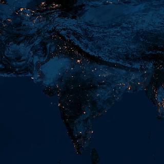
Also, check out India from space with satellite images from http://www.liveindia.com/earth/2.html

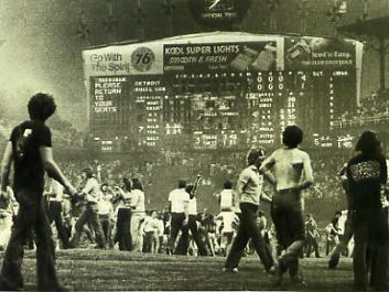 Disco Demolition Night
 Google map: CLEVELAND INDIANS, Jacob's Field
  Major League
 Google map: DETROIT TIGERS, Comerica Park
Comerica Park is one of the newest parks in the AL for one of the oldest teams. Detroit is home to Ty Cobb, Sparky Anderson, Lou Whitaker, and Magnum P.I.
Google map: DETROIT TIGERS, Comerica Park
Comerica Park is one of the newest parks in the AL for one of the oldest teams. Detroit is home to Ty Cobb, Sparky Anderson, Lou Whitaker, and Magnum P.I.

 Google map: KANSAS CITY ROYALS, Kauffman Stadium
George Brett helped make Kauffman Stadium famous with his attempt to bat .400 in 1980. However, even with that, most people will remember the famous 'Pine-tar' game in which Brett charged the ump in a critical game after his homerun was taken away for an illegal bat.
The Royals were also home to one of the best 2 sport players in Bo Jackson.
Google map: KANSAS CITY ROYALS, Kauffman Stadium
George Brett helped make Kauffman Stadium famous with his attempt to bat .400 in 1980. However, even with that, most people will remember the famous 'Pine-tar' game in which Brett charged the ump in a critical game after his homerun was taken away for an illegal bat.
The Royals were also home to one of the best 2 sport players in Bo Jackson.


 Google map: MINNESOTA TWINS, Hubert H. Humphrey Metrodome
The Twin's were home to the late, great Kirby Puckett who passed away this year. During his time on the field, the Twin's visited the World Series and gave the Metrodome plenty of TV exposure. Remember the Hefty Bag-looking outfield walls? Yuck!
Google map: MINNESOTA TWINS, Hubert H. Humphrey Metrodome
The Twin's were home to the late, great Kirby Puckett who passed away this year. During his time on the field, the Twin's visited the World Series and gave the Metrodome plenty of TV exposure. Remember the Hefty Bag-looking outfield walls? Yuck!


 Google Map: OAKLAND ATHLETICS, McAfee Coliseum
  Google map of: SEATTLE MARINERS, SAFECO FIELD.
  TEXAS RANGERS, Ameriquest Field in Arlington
  StateMaster.com is more than just a rehash of census data. They have grouped the information wisely and added comparison features and quick maps and graphs. The site is quick to load and easy to use.
Here's a description from their own site:
"Welcome to StateMaster.com, a unique statistical database which allows you to research and compare a multitude of different data on US states."
Where StateMaster.com excels is the ability to quickly access data and view it in a variety of graphs, maps, and charts. I only wish I had this site when I was writing my final papers. The website is well managed and easy to use. Their stats are well researched and in detail. They have everything from death rates to how 4th and 5th graders did in math.
A ticker sits on the top of the website and spouts interesting facts from their files. Make sure to click on it to find more info. Overall, a vital source of information and facts with a quick and easy to use website.
Site: StateMaster.com
StateMaster.com is more than just a rehash of census data. They have grouped the information wisely and added comparison features and quick maps and graphs. The site is quick to load and easy to use.
Here's a description from their own site:
"Welcome to StateMaster.com, a unique statistical database which allows you to research and compare a multitude of different data on US states."
Where StateMaster.com excels is the ability to quickly access data and view it in a variety of graphs, maps, and charts. I only wish I had this site when I was writing my final papers. The website is well managed and easy to use. Their stats are well researched and in detail. They have everything from death rates to how 4th and 5th graders did in math.
A ticker sits on the top of the website and spouts interesting facts from their files. Make sure to click on it to find more info. Overall, a vital source of information and facts with a quick and easy to use website.
Site: StateMaster.com
 U.S. meteorologists are finding a new use for hurricane satellites during the offseason. They will move the satellite to areas with more pressing needs.
From article:
U.S. meteorologists are finding a new use for hurricane satellites during the offseason. They will move the satellite to areas with more pressing needs.
From article:
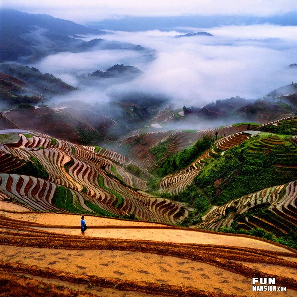 Take a tour of mainland China courtesy of FunMansion.com. The terraced landscapes and chiseled topography are sure to amaze you. Also, add in some beautiful sunsets and early morning mists for good measure. The rich photography captures the beauty of China.

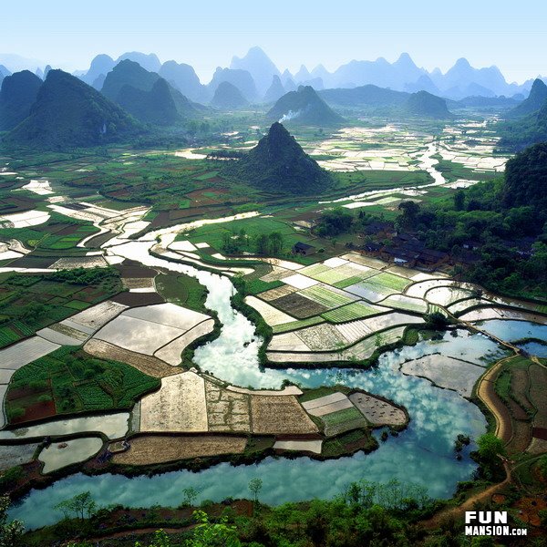 Click here for more pictures of China
 Merriam-Webster's Online Atlas is a good bookmark for anyone needing a quick reference to information on Singapore, or whatever country you need stats for in a hurry. The references are limited when compared to the CIA World Factbook, but is good for presentations or quick facts.
 Thanks to the power of Google Earth, one can now re-create the infamous 1906 earthquake that ripped up and shaped San Francisco, California. The USGS has enlisted Google Earth to utilized the ability to download and manipulate files (known as kml.files) and create a virtual tour of the site with multiple layers. A similar use of Google Earth in manipulated form was illustrated with Maxim Magazine's 100th Issue cover of Eva Longoria being a 100' banner in the middle of Nevada and seen on Google Earth (Previous Post).
Google Earth continues to show its potential and growth as a useful tool with multiple applications. One can only imagine the future uses of Google Earth.
Link: Virtual Tour of 1906 San Francisco Earthquake.
Thanks to the power of Google Earth, one can now re-create the infamous 1906 earthquake that ripped up and shaped San Francisco, California. The USGS has enlisted Google Earth to utilized the ability to download and manipulate files (known as kml.files) and create a virtual tour of the site with multiple layers. A similar use of Google Earth in manipulated form was illustrated with Maxim Magazine's 100th Issue cover of Eva Longoria being a 100' banner in the middle of Nevada and seen on Google Earth (Previous Post).
Google Earth continues to show its potential and growth as a useful tool with multiple applications. One can only imagine the future uses of Google Earth.
Link: Virtual Tour of 1906 San Francisco Earthquake.


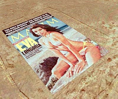 Who knew that Google Earth could be used to broadcast a 100 foot picture of 'Desparate Houswives' star Eva Longoria for satellites to see. Thanks to Maxim Magazine and their 100th issue, people with Google Earth, and traveling aliens, can catch a glimpse of the cover. It turns out that to help celebrate the 100th issue of Maxim Magazine, the company made a vinyl replica in the desert outside Las Vegas, NV.
The image is actually 75' x 110' and can be viewed by linking to Maxim Magazine here.
Also, the direct link location for the Kml file is here.
Who knew that Google Earth could be used to broadcast a 100 foot picture of 'Desparate Houswives' star Eva Longoria for satellites to see. Thanks to Maxim Magazine and their 100th issue, people with Google Earth, and traveling aliens, can catch a glimpse of the cover. It turns out that to help celebrate the 100th issue of Maxim Magazine, the company made a vinyl replica in the desert outside Las Vegas, NV.
The image is actually 75' x 110' and can be viewed by linking to Maxim Magazine here.
Also, the direct link location for the Kml file is here.
 SKYSCAPERNEWS.COM has posted a rather unique photo of all the world's tallest skyscapers and placed them into one background. Make sure to click 'enlarge' to view all of the buildings.
Skyscrapers Skyline
SKYSCAPERNEWS.COM has posted a rather unique photo of all the world's tallest skyscapers and placed them into one background. Make sure to click 'enlarge' to view all of the buildings.
Skyscrapers Skyline  The hard working people at NASA are known for their work looking at the stars, but few think about how much time they spent watching our own Earth. Head over to their Earth Observation Room and check out their high res pictures of the Earth. Then hit their 'data & images' page and you can make your own maps using their data.
Earth Observation Room
Data & Images
The hard working people at NASA are known for their work looking at the stars, but few think about how much time they spent watching our own Earth. Head over to their Earth Observation Room and check out their high res pictures of the Earth. Then hit their 'data & images' page and you can make your own maps using their data.
Earth Observation Room
Data & Images
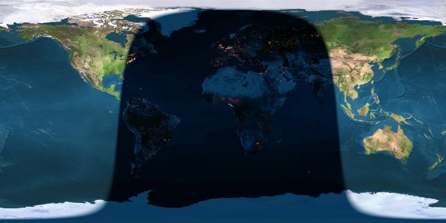 I get a lot of requests for the previous post on the Earth at Night. The same website has a few other nice pages to mention. It's run by John Walker out of Switzerland and you can find his main page at http://www.fourmilab.ch/
First, there is a live map of the planets in relation to the sun.
http://www.fourmilab.ch/cgi-bin/uncgi/Solar/action?sys=-Sf
Second, there is a nice sky chart showing the stars and their formations at any given location. Just update the lat and long and click for a map and you can see what your missing.
http://www.fourmilab.ch/cgi-bin/uncgi/Yoursky
I get a lot of requests for the previous post on the Earth at Night. The same website has a few other nice pages to mention. It's run by John Walker out of Switzerland and you can find his main page at http://www.fourmilab.ch/
First, there is a live map of the planets in relation to the sun.
http://www.fourmilab.ch/cgi-bin/uncgi/Solar/action?sys=-Sf
Second, there is a nice sky chart showing the stars and their formations at any given location. Just update the lat and long and click for a map and you can see what your missing.
http://www.fourmilab.ch/cgi-bin/uncgi/Yoursky
