Tuesday, October 31, 2006

Burj Dubai Live Construction Web Cam

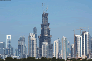
I wanted to make a special post about these web cams for Dubai (at bottom of post). It seems the media has really caught onto the frenzy of building of the BURJ DUBAI, which is soon to be the world's tallest skyscraper. The Royal Prince of Dubai is keeping the final height of the Burj Dubai a secret for now, but make no mistake about it, the building is meant to be and will be the world's largest upon completion. An observation deck will be located on the 124th floor to give you an idea of its height. Also on hand for the region are man made islands, luxury waterfront living, and the world's largest shopping mall, complete with ice rink and ski resort.

The building has become a beacon of controversy with its construction. The use of foreign labor at very low wages in a relatively poor area with high unemployment is only furthered by the use of money from OIL revenues to build it. Dubai wants to take a stand in the MIDDLE EAST and create a new type of country based more on tourism than oil. In the long run, oil will run dry and Dubai believes its early jump into the tourism market will pay off. Here's a list of things that Dubai has created in the last few years that will illustrate the point:

The Decemberists

The Decemberists - An indie band from Portland, Oregon.

Colin Meloy leads the Decemberists, a five-piece outfit whose pop sound has listeners comparing the band with the likes of Neutral Milk Hotel and Belle & Sebastian. Meloy, who hails from Missoula, MT, is the main songwriter for the group. Rounding out the lineup are Ezra Holbrook on drums, Nate Query on upright bass, Jenny Conlee on accordion, and Chris Funk on theremin and pedal steel guitar. Frontman Meloy previously devoted some time to an alternative country group before breaking off to pursue his craft as a singer/songwriter in the city of Portland, a period that eventually led to the Decemberists' formation. He also holds a degree in creative writing. In addition to her duties on the accordion, Conlee also plays piano. Funk is the band's newest member. Before Hush Records released the Decemberists' first album in 2002, the group put out an EP of five tracks. Their full-length debut, Castaways and Cutouts was re-released that same year on the Kill Rock Stars label, and the band began to accumulate a serious fan base. 2003 saw the release of Her Majesty, another fine collection of theatrical indie pop with british folk sensibilities that further cemented their growing reputation as a band to watch. The following year they released the five-part epic EP The Tain, based on the 8th century Irish poem of the same name, followed by their third full-length Picaresque in 2005. ~ Linda Seida, All Music Guide

Airbus: First, Blame the Software

Airbus: First, Blame the Software By Carol Matlack

Use of incompatible programs takes the rap, but behind that is a management team cobbled together from formerly separate companies

It sounds too simple to be true. Airbus' A380 megajet is now a full two years behind schedule—and the reason, CEO Christian Streiff admitted on Oct. 3, is that design software used at different Airbus factories wasn't compatible...(continue article)

GIS PILOT LINKS UPDATE

GIS PILOT LINKS UPDATE

MINNESOTA sees an update of 17 new GIS & Assessor links for both GIS PILOT and this blog. Updates include:

Monday, October 30, 2006

All you ever wanted to know about the Burj Dubai - soon to be world's tallest building

Photobucket - Video and Image Hosting
I've been following the construction in Dubai with the new man made islands (The Palm) and what will be the world's tallest skyscraper, the Burj Dubai. The best source of information for the building is the Burj Dubai skyscraper website. They update not only their building but skyscraper news from around the world. It has pictures, 3-d models, stats, and everything you need or want to know about the project.
A recent AFP news article shed some light on the construction of the tower and the working conditions by the labor force. Here's some info on the progress of the tower:
  • With two stories added every week, Burj Dubai is taking shape as the centerpiece of a 20-billion-dollar venture featuring the construction of a new district, "Downtown Burj Dubai," that will house 30,000 apartments and the world's largest shopping mall.

Photobucket - Video and Image Hosting
Dubai circa 1950

  • "At the moment, we've got around 2,500 workers on the tower site alone. We expect that to peak about a year from now at over 5,000 ... And for the whole site ... at any point in time, when the whole Downtown Burj Dubai district is under construction, there will be 20,000 men working here," Sang said.
  • He said the average wages of the south Asian laborers, who work in summer in temperatures reaching 50 degrees Celsius (122 Fahrenheit), are "probably in the range of a couple of hundred US dollars a month" for a shift of "eight to 10 hours" a day, six days a week.

The Burj Dubai will clock in at 800 meters tall. The Eiffel Tower goes around 300 meters tall for a good comparison. However, if plans go the way they do in Asia, China will beat the Burj Dubai in height soon.

Be sure to check the Dubai Webcam for a quick view of the city.

Also, check out the picture of the World's Tallest Buildings in one photo.

Geography Awareness Week

Geography Awareness Week November 12-18, 2006

Every year since 1987, National Geographic and other organizations have celebrated "geography awareness" during the third week of November, promoting the importance of geography in the U.S. and Canada. (Geography Awareness Week also includes GIS Day.)

This year, My Wonderful World is kicking off a multiyear, around-the-world program to engage everyone in learning about the diversity of our planet's people, places, and natural wonders. Our first stop is Africa! Below are Africa-related events and resources for educators, parents, and kids alike. Get started—and see what wonders you can discover.

Visit National Geographic Geography Awareness site

PERSIAN POLARIS GIS LINK

Well, if you speak Farsi then you'll have fun with this site. It's a GIS site called PERSIAN POLARIS from IRAN.

Super Friends Office Space Video

Let's start the week off right. How about the Super Friends doing a few scenes from "Office Space" (beware: some curse words)

Sunday, October 29, 2006

Inside Limbaugh's Studio As He Mocks Michael J Fox

.

Get More GIS Links at GIS PILOT

GIS PILOT has almost 2,000 GIS links in its database. Recent updates include:

GIS PILOT

Friday, October 27, 2006

GIS SITES Presents GIS News

GIS News for the Halloween weekend includes some of ESRI applications rising up in government news.

GOOGLE EARTH NEWS

GOOGLE EARTH, GOOGLE EARTH, GOOGLE EARTH, GOOGLE EARTH, GOOGLE EARTH, GOOGLE EARTH, GOOGLE EARTH, GOOGLE EARTH.
It seems like GOOGLE is poised to try to take over the world. They own most of the internet now and as long as they keep spitting out programs like GOOGLE EARTH I'm actually OK with that idea. It sure beats MicroSoft owning everything...

Observe an animation of the Coriolis effect over Earth's surface.

The Coriolis effect is just one of those things not thought about until you have to fly a plane to Miami from Alaska. This has never personally happened to me, but I'd like to think one day I will be more than the GIS PILOT and an actual pilot. So, here's wishing...

Anyway, here's a neat site with animations of how the Coriolis effect can throw off the pilot of an airplane if they are not paying attention.

"A plane flying from Anchorage, Alaska directly toward Miami, Florida would miss its target due to the Coriolis effect. The target location where the plane was headed when it took off has moved with Earth's rotation, so the plane would end up to the right of its original target."

Make Full-Color Mosaic Wall Maps With Your Printer

From From Matt Rosenberg, Your Guide to Geography.

You can create nice wall maps through National Geographic's website and your color printer by downloading an Adobe Acrobat document and assembling the printed pages. On their wall map site, you can download world, continent, regional, and even a few country maps for wall map production

Professor Uses Science, Math To Debunk Vampire, Ghost Myths

Photobucket - Video and Image Hosting

Talk about taking the fun out the holidays. This guy has calculated that vampires could not exist. If there was a vampire and it drank the blood of one person per month (this person would turn into a vampire, too) , then there would be only vampires roaming the earth within a few years.

WHAT'S IT LIKE TO WORK WITH MICHAEL J. FOX? - BIFF SINGS AN ANSWER

So, what's Michael J. Fox like? Biff from the Back to the Future Movies gives you an answer.

Thursday, October 26, 2006

DAM IT ALL - BEAVER T-SHIRTS!

Dam It All! Catch the Angry Beaver as he looks out on the world and wants to conquer it the only way he knows how - by building dams! Dark Tees, Light Tees, Thongs (Yeah! I went there!), Bags, cards, stickers, and gifts. Nice!

GIS PILOT - GIS LINKS

Satellite Image of Niagara Falls.
Blogger has another scheduled outage today, which I think is the 3rd in the last few weeks. So, if you experience slow or disrupted service to this site be sure to get your GIS LINKS from my main site, GIS PILOT.

Smokey's got a bark, but how much he bit is up for debate

'Bama players will whine about anything.

"Smokey IX, Tennessee's bluetick coonhound mascot, has been accused of biting an Alabama player before last week's game..."

...continue article

Wednesday, October 25, 2006

NEVADA Updates

Here's a few NEVADA sites that I've added:

NASA to launch 3-D mission to study sun

NASA to launch 3-D mission to study sun

by Veronica Smith

WASHINGTON (AFP) -NASA plans to launch a 3-D mission to study the sun, using twin satellites in mirror orbits to trace the fiery star's streams of energy and matter to Earth.

"We are at the dawning of a new age of solar observations," Russ Howard of the Naval Research Laboratory said at a NASA news conference.

The two-year Solar Terrestrial Relations Observatory (STEREO) mission will be the first to view the sun from two separate vantage points outside Earth's orbit.

...(continue article)

United States Population Density, Hurricane Paul, and the Palm Islands (Man made Island chain)

NASA is home to one of my favorite sites with the EARTH OBSERVATORY. They offer daily images of satellite photos and maps. A few of the items updated in the last week include a United States Population map, Satellite images of the Palm Islands (something I've posted about before), and images of Hurricane Paul. Be sure to check out the Hi-Res images of the Volga River delta for some great imagery.

Google Earth Rocks the Vote

Google Earth Rocks the Vote

By Juan Carlos Perez, IDG News Service

Google has assembled a wealth of information about the upcoming U.S. general election and will display links to it on its Google Earth mapping application.

Google Earth users now see stars on the U.S. map wherever there is a race in the Nov. 7 election. A number of congressional seats and state governorships are up for grabs.

Clicking on a star opens up a bubble with information about races in that area and links to a variety of information resources, like the Web sites for the U.S. Federal Election Commission and the Center for Responsive Politics’ OpenSecrets.org, which gathers information about campaign contributions. Below each candidate are links that trigger Google Web, image, and news searches about them. (...Continue Article)

Tuesday, October 24, 2006

Enhanced 911 mapping enforces correct local address displays

Here I found an article about Camden County, Missouri and the 911 addressing that is being updated in the region. I do a lot of flood mapping for Camden County and there's nothing like trying to find an address of "Route XX, Box XX." It's a lot easier for me and pizza deliveries guys if the roads actually have names and house have numbers. But, I'm a progressive person.

Want proof? Check out the Google Map on a part of Camden County. Make sure to have the map or hybrid overlay on to see the road names. Some are legit, most are "Lake Road" and "Y" road names.

On another note, Camden County is home to a ton of real estate in the form of condos and houses. That's pretty much what the area's known for. Miller County and Morgan County are part of this region, known collectively as Lake of the Ozarks, a man made lake created by dams (just like my region in East Tennessee). Miller and Morgan have added GIS sites in the last few months and Camden county is going to have on up by next year. The key to a good GIS site like this is usually tied to an area that needs it for real estate and tax assessor reasons. Just something to keep in mind for students looking for projects in the future.

By Lake Sun staff Published: Tuesday, October 24, 2006

CAMDENTON - Keeping up with development in Camden County can mean adding up to 15 new roads each month, according to the Enhanced 911 mapping and addressing staff of the sheriff's department.

That's hundreds of new addresses each year that have to be mapped, logged and coordinated with the U. S. Postal Service and entered into the data base for emergency services, according to Sheriff John Page.

The importance of getting the correct numbers and size of letters on homes and offices can't be overlooked, according to Page. In an emergency, locating the right address can be a lifesaving matter.

Deputies, firefighters and ambulance drivers depend on finding clearly visible numbers on buildings in order to know they are in the right location. As more multi-family and multi-level units, condominiums and strip malls move into the area, following the correct procedure for numbering a building becomes even more important, Page said. (...Continue Article)

U.S. alters its spelling of Ukraine city

By HARRY DUNPHY, Associated Press Writer Thu Oct 19, 6:23 PM ET

WASHINGTON - The Ukrainian capital of Kiev is now Kyiv, as far as the U.S. government is concerned. And the State Department says the spelling change has nothing to do with American hopes of wooing the one-time Soviet republic more into the Western orbit.

About half of Ukraine's 47 million people are Russian speakers, and Kiev is the Russian spelling.

Ukraine's Western-leaning President Viktor Yushchenko, elected on the wave of the 2004 Orange Revolution's mass protests against election fraud, has sought to take his nation out of Russia's influence and join NATO and the European Union. (...Continue Article)

Tennessee GIS Links

RUTHERFORD COUNTY, TN GIS Link is now up and running. I have added Putnam County GIS and Lincoln County GIS links up as well. These 2 are from E-Maps Plus which are limited in features and they have a bad habit of changing IP addresses and creating dead links.

Monday, October 23, 2006

Borat -The first 4 minutes of his Movie

Borat -The first 4 minutes of his Movie

Panama backs $5.25B Canal expansion plan

By WILL WEISSERT, Associated Press Writer 2 hours, 42 minutes ago

PANAMA CITY, Panama - Panama is embarking on an ambitious expansion of its storied canal to accommodate today's larger ships, recognizing that one of the engineering wonders of the world badly needs an update.

In a referendum marred by relatively low turnout, voters Sunday authorized the construction of a third set of locks so that vessels too wide for the current 108-foot-wide sections can take the shortcut between the seas.

"Today we have laid the groundwork to build a better country together," said President Martin Torrijos, who staked his political future on the plan.

His government said the $5.25 billion project, the largest in the canal's 92-year history, would create 40,000 jobs in a country where 40 percent of people live poverty and were unemployment sits at 9.5 percent. Currently the canal employs 8,000.

The Panama Canal Authority, the autonomous government agency that runs the waterway, says the project will double the capacity of the canal. Construction is set to begin in 2007 and will take up to eight years to complete. It will be paid for by increasing tolls, which will pay back $2.3 billion in loans to cover the initial costs. ...(continue article)

Saturday, October 21, 2006

Korea's Dr. Strangelove

I came across this editorial on North Korea's Kim Jong-il and found the retrospect interesting. It's from the Washington Times, so just ignore that fact and enjoy it ( I joke). But, Kim Jong is an enigma that the entire world will have to deal with soon so this editorial offers a background on the freaky guys history.
Korea's Dr. Strangelove By Arnaud de Borchgrave

Friday, October 20, 2006

MORGAN County Missouri GIS Link

Whoever pushed the funding for GIS sites around Lake of the Ozarks is one smart person and they've made my life a Heck of a lot easier. 3 main counties in this region of Missouri (Camden, Miller, and Morgan) are home to a boatload of subdivisions and condos. Now, 2 counties (Morgan and Miller) have taken themselves off of my 'bad county' list and put up a GIS links. Camden county is due next year, which is the golden spike in the transcontinental railroad. That's where most of our business is and we're looking forward to the day they go public.

Thursday, October 19, 2006

World's pollution hotspots mapped

A US-based environmental charity has documented what it calls the 10 most polluted places on the planet.

The Blacksmith Institute says three of the hotspots are in Russia, with the remainder dotted in various countries.

Heavy metals such as lead are the main sources of pollution, with 10 million people affected across the locations.

The institute surveyed scientists and environmental bodies across the world to compile its list, and is running clean-up projects in some of the sites.

The charity has focused largely on locations where people are affected by the pollution. ( continue article )

Scientists Say Hawaii Hit by Two Quakes

The data from the Hawaii earthquake continues to pour in and new data points to a possible one-two punch as 2 individual earthquakes may of have rattled the region.

By JAYMES SONG Associated Press Writer

HONOLULU (AP) -- Scientists are investigating whether a magnitude-6.0 earthquake that rocked Hawaii within minutes of Sunday's 6.7 temblor was a separate quake and not an aftershock.

The lead scientist at the U.S. Geological Survey's Hawaiian Volcanoes Observatory and a seismologist at the Pacific Tsunami Warning Center said Wednesday they were two independent events. Others aren't so sure.

The 6.7-magnitude quake struck 12.5 miles northeast of the Big Island's Kona airport at a depth of 24 miles at 7:07 a.m. Sunday. Seven minutes later, the 6.0-magnitude quake struck 27 miles north of the airport at a depth of about 12.5 miles. (continue article)

Wednesday, October 18, 2006

The Science of the Red Planet

I've been keeping tabs on the Mars missions and Space.com is keeping me updated with great articles on the current and upcoming projects. Here's a sample of some expectations on the MRO project.

NASA Orbiter Ready for Red Planet Science By Tariq Malik

NASA’s latest spacecraft to orbit Mars has already found new clues to the red planet’s changing environment, and the best is yet to come, mission managers said Monday.

The Mars Reconnaissance Orbiter (MRO) is still weeks away from beginning its planned science mission, but the immense probe has thrilled scientists with initial images and data pointing to a variable polar environment, ancient soaking events that produced clays, and relatively new—geologically speaking—gullies carved into the shadowed rim of a southern crater.

“We have another new Mars,” said Steve Saunders, MRO program scientist at NASA’s Washington D.C. headquarters, in a mission briefing. “Every time we go to Mars with a new set of instruments, we see a different planet.”

...continue article

Privacy under attack, but does anybody care?

By Bob Sullivan Technology correspondent MSNBC It's vanishing, but there's no consensus on what it is or what should be done

Someday a stranger will read your e-mail, rummage through your instant messages without your permission or scan the Web sites you’ve visited — maybe even find out that you read this story.

You might be spied in a lingerie store by a secret camera or traced using a computer chip in your car, your clothes or your skin.

Perhaps someone will casually glance through your credit card purchases or cell phone bills, or a political consultant might select you for special attention based on personal data purchased from a vendor. (continue article)

Tuesday, October 17, 2006

Space Elevator: Hoist to the Heavens

Space Elevator: Hoist to the Heavens

Admittedly, at least for now, the idea of a beanstalk-like space elevator connecting Earth and space is a stretch.

But next month's X Prize Cup will host the Space Elevator Games, an unprecedented challenge for today's engineers looking at ways to alter the future of access to space.

Teams from around the country will gather October 20-21 in Las Cruces, New Mexico to compete for $400,000 in prize money as part of NASA's Centennial Challenges--the space agency's program of prize contests to stimulate innovation and competition in solar system exploration.

No matter how you look at it--from the top down or bottom up--building a full-scale space elevator is an uphill battle. But at least physics is in your favor. ... continue article

GIS PILOT - GIS LINKS

GIS PILOT is a virtual library of to almost 2,000 GIS LINKS. The site is divided up by state and country to allow for quick access to GIS LINKS for the geographic area you are looking for.

NASA Data Captures El Niño's Return In The Pacific

The Cycle's Back!!!!!!!!

Sorta like a drunk uncle that slips back for the holidays to start trouble, our little friend El Niño looks to be hitting the spiked egg nog just in time for the holidays.

Many recognize the name El Niño just enough to know that weathermen and farmers dread it. But, what really is El Niño and why should you care? Well, NASA is on it for you. Indications are that this cycle is less intense than the last one in 1997-98. However, like that drunken Uncle, don't turn you back on it because that doesn't mean it's not going away anytime soon.

Here's what NASA has to say about the system so far:

  • NASA satellite data indicates El Niño has returned to the tropical Pacific Ocean, although in a relatively weak condition that may not persist and is currently much less intense than the last major El Niño episode in 1997-1998.
  • Over the past several weeks, NASA's Aqua and Jason satellites have observed a general warming of ocean temperatures and a rise in sea surface heights in the central and eastern Pacific along the equator, both indicators of El Niño development.
  • "The present conditions indicate that the intensity of this El Niño is too weak to have a major influence on current weather patterns," said Bill Patzert, oceanographer and climatologist at the NASA's Jet Propulsion Laboratory, Pasadena, Calif. "But, if the ocean waters continue to warm and spread eastward, this event would likely strengthen, perhaps bringing much-needed rainfall to the southwestern and southeastern United States this winter."

Read more about El Niño from NASA.

3rd Grade Geography Test

Take the 3rd Grade Geography Test and see if you can graduate to the 4th grade in time. http://www.pibmug.com/files/map_test.swf

Rand McNally turns 150

Rand McNally turns 150

By DAVE CARPENTER, AP Business Writer

SKOKIE, Ill. - As the Great Chicago Fire was ravaging the city in 1871, William Rand and Andrew McNally saved their business by burying two printing machines on the sandy Lake Michigan shore.

No such clear-cut solution emerged to preserve Rand McNally & Co.'s dominance more than a century later, when the mapmaker lost its way in the age of the Internet.

But following two ownership changes and a bankruptcy reorganization, the storied company appears to have finally regained its bearings. A sales decline has been reversed, the company says profitability is up over 30 percent since its 2003 overhaul and it is even poised to make acquisitions. ...(continue article)

Mars images hint at recent climate swings

A dust layer sandwiched between layers of ice near Mars's north pole suggests the planet's climate has shifted dramatically in the past 100,000 years or so, reveal images recently obtained by NASA's Mars Reconnaissance Orbiter (MRO).

Previous research has suggested that the tilt of Mars's axis of rotation fluctuates from 10° to 40° with time, leading to major climate shifts . . . (continue article)

Monday, October 16, 2006

Antarctic ice collapse tied to greenhouse gases

Photobucket - Video and Image Hosting

By Alister Doyle, Environment Correspondent

OSLO (Reuters) - Scientists said on Monday that they had found the first direct evidence linking the collapse of an ice shelf in Antarctica to global warming widely blamed on human activities.

Shifts in winds whipping around the southern Ocean, tied to human emissions of greenhouse gases, had warmed the Antarctic peninsula jutting up toward South America and contributed to the break-up of the Larsen B ice shelf in 2002, they said.

"This is the first time that anyone has been able to demonstrate a physical process directly linking the break-up of the Larsen Ice Shelf to human activity," said Gareth Marshall, lead author of the study at the British Antarctic Survey.

The chunk that collapsed into the Weddell Sea in 2002 was 3,250 sq kms (1,255 sq miles), bigger than Luxembourg ...(continue Article)

Europe's Spaceport

Photo: ESA
The European Space Agency (ESA) is one of my favorite news groups that I receive notices on. I thought I'd explain a little more about the agency because the aspect I find most interesting is the space port they have established in the northeast of South America in French Guiana, an overseas department of France. In detail, this is an excellent decision to put launch pads on the edge of the Amazon. Without those details many are left wondering why.

The ESA's website has a great, detailed explanation on their projects and people. French Guiana is located almost on the equator which reduces fuel during liftoff and provides a prime orbit for their payloads. So, be sure to check out (ESA's) Europe's Spaceport

'Jolted' Fish Gave Early Warning Of Hawaii Quake & Hawaii sinking

Fish in a lagoon at a Hawaiian resort began to jump out the water like they were being jolted with electricity minutes before a 6.6 magnitude earthquake rattled the islands, causing blackouts and landslides, according to Local 6's Erik von Ancken, who is vacationing in the area.

Von Ancken said he was on a beach during a visit to the islands over the weekend when he noticed the fish.

"The fish started to jump out of the water in a lagoon, like jump out of the water like a jolt," Local 6's Erik von Ancken said. "Obviously, they sensed it before we did and then everything started shaking."

The quake hit at 7:07 a.m. local time Sunday, 10 miles north-northwest of Kailua-Kona, a town on the west coast of Hawaii Island, also known as the Big Island, said Don Blakeman of the National Earthquake Information Center, part of the U.S. Geological Survey.

... continue article

also, check out this article on Hawaii's Big Island sinking very slowly

Balcony Shark Hunter

ROBBIE Hughes says people are genuinely shocked upon hearing he reels in man-eating sharks from his balcony six floors above a Gold Coast lake.

Not so much shocked at the bizarre nature of his fishing habits but more surprised at how many sharks are found in Gold Coast canals and rivers.

Mr Hughes, 26, fishes for bull sharks off his Varsity Lakes apartment balcony above Lake Orr in between watching television and playing video games.

He uses a boat rod to reel the sharks up to the carpark level of the apartment block before his friend David Rolando races downstairs to hook them with a gaff.

...continue article

Sunday, October 15, 2006

Virtual Nintendo Entertainment System with 395 Games!

Virtual Nintendo Entertainment System with 395 Games!

Attention! If you've got java you can run the Virtual Nintendo Entertainment System. Carry on.

French hottie sings

French hottie sings

Do it for the Children!

C'mon! Do it for the Children! http://www.cafepress.com/doitforthe

Friday, October 13, 2006

Group sues Santa Clara County over access to digital mapping data

not Santa Clara
Group sues Santa Clara County over access to digital mapping data
An open-government group sued Santa Clara County on Wednesday seeking to break up what it called a "government monopoly" on the county's digital mapping data.

The California First Amendment Coalition accuses the county of violating the state Public Records Act by charging hefty fees to access the so-called "base map" of the county's geographic information system, or GIS. Santa Clara claims the data is copyrighted and proprietary. (continue article)

Thursday, October 12, 2006

Embarrassing...

In an embarrassing situation, the Buffalo Sabres forgot to call each other to see what they were supposed to wear that night.

Hubble's New Images - Galaxy caught in the making

New Hubble images have provided a dramatic glimpse of a large massive galaxy under assembly as smaller galaxies merge. This provides the best demonstration so far that large massive galaxies form by merging smaller ones.

This formation process has commonly been thought to be the way galaxies grew in the young Universe. New Hubble observations of the radio galaxy MRC 1138-262, nicknamed the 'Spiderweb Galaxy', have shown dozens of star-forming satellite galaxies in the actual process of merging.

In nature spiders earn our respect by constructing fascinating, well-organised webs in all shapes and sizes. But the beauty masks a cruel, fatal trap. Analogously, the NASA/ESA Hubble Space Telescope has found a large galaxy 10.6 thousand million light-years away from Earth that is stuffing itself with smaller galaxies caught like flies in a web of gravity. The galaxy is so far away that astronomers . . . (continue Article)

Wednesday, October 11, 2006

Cancun back a year after Hurricane Wilma

Using similar techniques to those in Dubai to build the Palms Islands, Cancun has finished rebuilding the coral white sand beaches of its shores. Using sand from as much as 20 miles offshore, ships pumped the new shoreline to replace almost all of the loss due to Hurricane Wilma. It's been a success and quick recovery with an added bonus - the shores are now bigger than before.

GIS SITES -- Secrets to talking to live operator

GET HUMAN & NO PHONE TREES

Here's a couple of websites for whenever you call your cable or phone company and get carpal tunnel from hitting buttons for 20 minutes just to talk to an operator to fix the bill they screwed up.

GETHUMAN is an online database of company secrets to avoid those menus and go directly to a human agent. Their list includes all the utility companies as well as credit cards and insurance groups.

Another site that's popped up is NoPhoneTrees which does similar work but also takes it up one notch and does most of the work for you than transfer the call back to your number. Nice.

Tuesday, October 10, 2006

African Dust Storms Stifle Hurricanes

Here's a great article about Hurrican formation and the cycles of dust storms in the Sahara Desert. Here's a sample

"Westward swirling clouds of dust from the Sahara Desert might be putting a damper on Atlantic Ocean hurricanes, a new study suggests.

Researchers analyzing satellite data from the past 25 years found that during years when the dust storms rose up, fewer hurricanes swept across the Atlantic, while periods of low dust storm activity were followed by more intense hurricane activity. Hurricanes are fueled by heat and moisture, and it's thought the dust storms help muffle the storms before they fully develop. By doing so, however, the dust storms could shift a hurricane's direction further to ...(continue article)"

The David Zucker Albright Ad

Wow!

This is screaming through the web thanks to Drudge, so give it a whirl.

Sunday, October 08, 2006

GIS PILOT

Photobucket - Video and Image Hosting

Blogger's being a touch difficult lately, which is nothing unusual. So, if you need access to the GIS LINKS head to my other site GIS PILOT for all the same and more GIS links to online GIS data, downloads, and links.

TEXAS GIS Links added

Thanks for the tip from Justin at www.gis-geoblog.blogspot.com for the City of Longview, TX GIS link and the The Columbia Regional Geospatial Service Center (The Columbia Center).

Saturday, October 07, 2006

Niau atoll Satellite Image

The Niau atoll, located in the central South Pacific Ocean, is highlighted in this Proba image. Niau is one of nearly 80 coral reef atolls that forms the Tuamotu Archipelago in French Polynesia. The Tuamotu is the largest chain of atolls in the world, stretching some 2000 kilometres, and has a total land area of 850 square kilometres.

The Tuamotu Archipelago, first discovered by Ferdinand Magellan in 1521, is divided into nine groups, with Niau belonging to the Centre West Group. The archipelago was dubbed the ‘Dangerous Archipelago’ a couple hundred years ago because a high number of ships wrecked on its reefs and atolls. The coral reefs have formed atop a volcanic mountain range that spanned the area two to three million years ago. The islands produce pearl shell and copra (the dried meat of coconuts from which coconut oil is extracted).

Niau, 8 km in diameter and 8 m high, lies near the west end of the archipelago some 250 km east-northeast of Tahiti. As seen in the image, Niau is comprised of a completely enclosed 3.3-square-km lagoon. The narrow strip of land surrounding the lagoon is . . . (continue ESA article) <

NASA Data Captures El Niño's Return In The Pacific

NASA Data Captures El Niño's Return In The Pacific
NASA satellite data indicates El Niño has returned to the tropical Pacific Ocean, although in a relatively weak condition that may not persist and is currently much less intense than the last major El Niño episode in 1997-1998.

Over the past several weeks, NASA's Aqua and Jason satellites have observed a general warming of ocean temperatures and a rise in sea surface heights in the central and eastern Pacific along the equator, both indicators of El Niño development.

"The present conditions indicate that the intensity of this El Niño is too weak to have a major influence on current weather patterns," said Bill Patzert, oceanographer and climatologist at the NASA's Jet Propulsion Laboratory, Pasadena, Calif. "But, if the ocean waters continue to warm and spread eastward, this event . . . (continue article)

Friday, October 06, 2006

WHY THE MOON IS NEVER FULL.

Here's a neat article about the technical aspects of the Moon being full from Space.com.
The next Full Moon will occur March 6. Or will it? Technically speaking, the Moon is never full.

Let's back up a moment. The actual moment of Full Moon that time when the Moon is opposite to the Sun in the sky can be found in any almanac. Some newspapers also provide the exact time. It occurs each time the Moon has swung around on its roughly 29-day orbit.

We could then say that the Moon is officially "full" for only one minute. The Full Moon of Feb. 6, for instance, occurred at 3:14 a.m. EST. In the very strictest sense, one minute before that time, the phase of the Moon was a waxing gibbous; one minute after that time, it was a waning gibbous phase.

But the mechanics of the celestial alignment -- the Sun, Earth and Moon all in a line -- adds a twist to the idea of fullness.

The disk of the Moon can appear 100 percent sunlit from Earth only if it is diametrically opposite to the Sun in the sky. But at that moment the Moon would be positioned in the middle of Earths shadow -- and in total eclipse. So in any month when there is no eclipse, there is an ever-so-slight . . . (continue article)

Space debris hit shuttle during last mission

Space debris hit shuttle during last mission

By Irene Klotz CAPE CANAVERAL, Florida (Reuters) - A piece of space debris punched a small hole in one of space shuttle Atlantis' radiator panels during its recent 12-day spaceflight, NASA said on Thursday.

Damage from debris has been NASA's top safety issue since the destruction of shuttle Columbia in February 2003, when insulating foam came off the ship's fuel tank during launch and punched a hole in the shuttle's protective heat shield.

The radiator damage, which measures slightly more than one-tenth of an inch in diameter, was found during . . . (continue article)

Introducing Gothamist Maps, the best way to see what's going on

Introducing Gothamist Maps, the best way to see what's going on. This Google Maps Mash-up takes Manhattan and mixes in all the fires, thefts, and police calls they can manage into one map. This in one person who should keep busy.

Thursday, October 05, 2006

Mexican archeologists make major Aztec find

Mexican archeologists make major Aztec find
By Gunther Hamm Wed Oct 4, 4:56 PM ET

MEXICO CITY (Reuters) - Mexican archeologists have made the most significant Aztec find in decades, unearthing a 15th century altar and a huge stone slab at a ruined temple in the throbbing heart of Mexico City.

The works were uncovered last weekend at the Aztec empire's main Templo Mayor temple, near the central Zocalo square, which was used for worship and human sacrifice. It was the most meaningful find since electricity workers stumbled upon an ... (continue article)